Chest opened
+${chestReward.xp} XP
Explorer
NOUVEAU ×${chestReward.collectible.quantity}
tapez pour fermer
Chest locked

Open chests in the app

Around Us is built for your phone — chests unlock when you walk, explore and capture nearby places.

Enable Location

We need your location to show you interesting places around you

Discover nearby places

Find interesting locations and hidden gems around you

Precise directions

Get accurate directions and distances to places

Your location is never shared with other users. It's only used when you tap the location button.

South Manitou Island

Log in to your account

Start exploring — it's free

Trusted by 72,879 travelers worldwide

Continue with Google
Continue with Apple
or

We will send you a code to connect

By continuing, you accept our Terms and Conditions and our Privacy Policy

Check your inbox

We've sent a pincode in your inbox. Please enter the code below.

South Manitou Island
Discussion Reviews 1 Photos
15.2k Popularity

South Manitou Island, Island in Sleeping Bear Dunes National Lakeshore, United States.

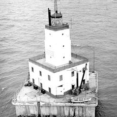
South Manitou Island is a Lake Michigan island within Sleeping Bear Dunes National Lakeshore, featuring stony beaches and forested interior. The land shows layered limestone formations shaped by ancient glaciers, with old farmstead remnants and maritime structures scattered across it.

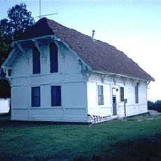
The island took shape thousands of years ago when glaciers sculpted the landscape and left behind layered limestone now visible today. People later settled there to farm and operate shipping services, building communities that lasted until economic changes made life there difficult.

The island held deep meaning for Native American communities who knew its shores and forests before farming and shipping brought new ways of life. Traces of those earlier connections remain visible in the landscape and in stories about how people once lived there.

A ferry operates from the mainland to reach the island, and booking in advance is necessary since service is limited and seasonal. Bring water and food with you, as facilities on the island are minimal and there are no shops or restaurants.

A grove of old white cedar trees on the island includes specimens over 500 years old, among the oldest living things in the region. When one of these ancient trees fell, its cut surface revealed more than 500 growth rings marking each year of its life.

The community of curious travelers

AroundUs brings together thousands of curated places, local tips, and hidden gems, enriched daily by 60,000 contributors worldwide.

Start exploring
GPS coordinates
45.02778,-86.11944
Latest update
December 7, 2025 19:31
Around this place
Glen Haven, Michigan
United States of America

Glen Haven, Michigan

16 km
South Manitou Island Lighthouse
United States of America

South Manitou Island Lighthouse

3 km
Port Oneida Rural Historic District
United States of America

Port Oneida Rural Historic District

15 km
SS Jarvis Lord
United States of America

SS Jarvis Lord

12.5 km
North Manitou Shoal Light Station
United States of America

North Manitou Shoal Light Station

12.8 km
United States of America

Manitou Passage Underwater Preserve

12.2 km
North Manitou Island Lifesaving Station
United States of America

North Manitou Island Lifesaving Station

15.2 km
United States of America

North Manitou Island Light

12.8 km
George Conrad Hutzler Farm
United States of America

George Conrad Hutzler Farm

796 m
Hutzler's Barn
United States of America

Hutzler's Barn

1.2 km
Boathouse #2
United States of America

Boathouse #2

15 km
United States of America

Fife Lake State Forest

610 m
United States of America

Synchronicity Gallery

17.6 km
United States of America

Scenic viewpoint

16.4 km
Sleeping Bear Inn
United States of America

Sleeping Bear Inn

15.6 km
United States of America

Islands Lookout

17.7 km
United States of America

Pyramid Point

16.8 km
United States of America

Sleeping Bear Point

14.2 km
United States of America

Overlook Cottenwood Trail

17.2 km
United States of America

Mountain Flowers

17.1 km
United States of America

Lookout Point

16.6 km
United States of America

Scenic viewpoint

3.6 km
United States of America

Scenic viewpoint

9.4 km
United States of America

Scenic viewpoint

18.2 km
United States of America

Scenic viewpoint

16.5 km
United States of America

Scenic viewpoint

17.9 km
United States of America

Scenic viewpoint

17.5 km
United States of America

Scenic viewpoint

14.9 km
Show the full map
Reviews
Share your experience

No review yet

Discussions
Start a discussion...

No discussion yet

« South Manitou Island - Island in Sleeping Bear Dunes National Lakeshore, United States » is provided by Around Us (aroundus.com). Images and texts are derived from Wikimedia project under a Creative Commons license. You are allowed to copy, distribute, and modify copies of this page, under the conditions set by the license, as long as this note is clearly visible.

Discover hidden gems everywhere you go!

From secret cafés to breathtaking viewpoints, skip the crowded tourist spots and find places that match your style. Our app makes it easy with voice search, smart filtering, route optimization, and insider tips from travelers worldwide. Download now for the complete mobile experience.

Around Us App Screenshot

A unique approach to discovering new places

Le Figaro

All the places worth exploring

France Info

A tailor-made excursion in just a few clicks

20 Minutes

Around Us
Travel Guide & Maps
Download

Send to your phone

QR Code
1

Open the camera app on your mobile.

2

Point at the QR code with your camera. A notification will appear.

3

Tap the notification to open the link.