Ashville, County seat in Western North Carolina, United States
Asheville is a city nestled where the French Broad and Swannanoa rivers meet in the western reaches of North Carolina. The surrounding landscape features the rolling mountains and valleys typical of the Blue Ridge region, with the city spreading across varied terrain in between.
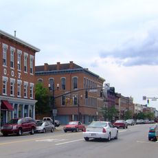
European settlers established the area in 1784, originally calling it Morristown until adopting its current name in 1797. The railroad's arrival in the 1880s spurred rapid growth and transformed it into a manufacturing and commercial hub.
The city's name reflects its transformation from a small frontier settlement into a regional hub during the late 1700s. Walking through downtown, you'll notice how different neighborhoods show the influence of various waves of development and artistic communities that shaped its character.
The city is easily accessible via the I-240 loop that connects to major highways and routes, with clear signage making navigation straightforward. Visitors should plan for mountain roads and varying terrain depending on their route to reach different parts of the area.
The economic hardship of the 1930s paradoxically led to the preservation of numerous Art Deco buildings that might otherwise have been replaced or demolished. Today these structures remain concentrated in the downtown area, creating a time capsule of design from that era.
The community of curious travelers
AroundUs brings together thousands of curated places, local tips, and hidden gems, enriched daily by 60,000 contributors worldwide.