New York State Thruway, Highway system in New York State, US
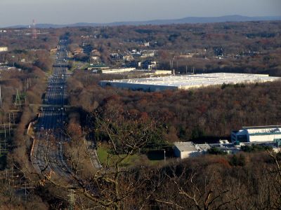
The New York State Thruway is a toll highway system that runs roughly 570 miles across New York State, linking cities such as Buffalo, Syracuse, Albany and the New York metropolitan area. The roadway typically offers multiple lanes in each direction, accompanied by service plazas and toll gantries that appear at regular intervals.
Construction began in the late 1940s when New York State sought to create a modern expressway network, and the first segment opened in 1954. Over the following decades, the system grew through additional sections and connections until it reached its current span.
The name Thruway recalls the great era of American highway building, and today truck drivers and commuters alike use this route daily for work and travel. Along the way, urban areas alternate with rural stretches, so a single journey introduces travelers to different landscapes and ways of life across the state.
Numerous service plazas along the route offer restrooms, gas stations and small restaurants, so travelers can take breaks comfortably during longer drives. Electronic toll systems simplify passage, and most sections are well lit even at night.
A dedicated unit of the New York State Police patrols exclusively on this road and handles safety and traffic flow. This specialized force was established as early as the 1950s to respond to the particular demands of such a long toll connection.
The community of curious travelers
AroundUs brings together thousands of curated places, local tips, and hidden gems, enriched daily by 60,000 contributors worldwide.