Chest opened
+${chestReward.xp} XP
Explorer
NOUVEAU ×${chestReward.collectible.quantity}
tapez pour fermer
Chest locked

Open chests in the app

Around Us is built for your phone — chests unlock when you walk, explore and capture nearby places.

Enable Location

We need your location to show you interesting places around you

Discover nearby places

Find interesting locations and hidden gems around you

Precise directions

Get accurate directions and distances to places

Your location is never shared with other users. It's only used when you tap the location button.

Town of Clay

Log in to your account

Start exploring — it's free

Trusted by 72,899 travelers worldwide

Continue with Google
Continue with Apple
or

We will send you a code to connect

By continuing, you accept our Terms and Conditions and our Privacy Policy

Check your inbox

We've sent a pincode in your inbox. Please enter the code below.

Discussion Reviews 1 Photos
13.7k Popularity

Town of Clay, Administrative division in Onondaga County, New York, US

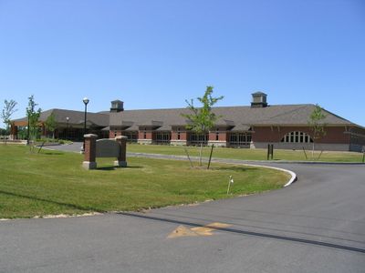
The Town of Clay is a municipality in Onondaga County spanning suburban areas with residential neighborhoods, commercial zones, and public facilities. The landscape includes several parks, recreational sites, and shopping centers that structure daily community life.

This area emerged in 1791 from the Central New York Military Tract and separated from the Town of Cicero in 1827. The name was chosen to honor Henry Clay, a major political figure of that era.

Community centers host neighborhood gatherings and local events where residents come together for celebrations and seasonal festivities. These spaces shape the social fabric and show how neighbors maintain connections in their daily lives.

Visitors can easily reach the municipality through major highways connecting to Syracuse and nearby areas. The parks and facilities are accessible along main routes and provide various activity options.

The North Syracuse Central School District serves as a focal point for families and sets the rhythm of community life. Many residents structure their year around school events and activities.

The community of curious travelers

AroundUs brings together thousands of curated places, local tips, and hidden gems, enriched daily by 60,000 contributors worldwide.

Start exploring
Location
GPS coordinates
43.18662,-76.20654
Latest update
December 7, 2025 20:25
Around this place
Alliance Bank Stadium
United States of America

Alliance Bank Stadium

12.4 km
Hancock Field Air National Guard Base
United States of America

Hancock Field Air National Guard Base

10.7 km
United States of America

Sainte Marie among the Iroquois

10.5 km
Syracuse Air Defense Sector
United States of America

Syracuse Air Defense Sector

11.2 km
United States of America

Central New York Regional Market

13 km
Goethe–Schiller Monument
United States of America

Goethe–Schiller Monument

14.1 km
Long Branch Park
United States of America

Long Branch Park

8.3 km
Mrs. I. L. Crego House
United States of America

Mrs. I. L. Crego House

12.4 km
Lucius Gleason House
United States of America

Lucius Gleason House

9.2 km
Solvay Public Library
United States of America

Solvay Public Library

14.4 km
Alvord House
United States of America

Alvord House

12.4 km
Gang House
United States of America

Gang House

13.7 km
Stone Arabia School
United States of America

Stone Arabia School

10.7 km
Garrett House
United States of America

Garrett House

15.3 km
AMF Bowling
United States of America

AMF Bowling

11.4 km
O.M. Edwards Building
United States of America

O.M. Edwards Building

15 km
Chapman House
United States of America

Chapman House

13.9 km
Ziegler House
United States of America

Ziegler House

14.5 km
Schroeppel House
United States of America

Schroeppel House

2.3 km
Sweet Memorial Building
United States of America

Sweet Memorial Building

8.9 km
John G. Ayling House
United States of America

John G. Ayling House

15 km
Harriet May Mills House
United States of America

Harriet May Mills House

15 km
Louis Will House
United States of America

Louis Will House

15.1 km
Alton Simmons House
United States of America

Alton Simmons House

15.3 km
St. John's Episcopal Church
United States of America

St. John's Episcopal Church

9.1 km
Baldwinsville Village Hall
United States of America

Baldwinsville Village Hall

10.8 km
North Salina Street Historic District
United States of America

North Salina Street Historic District

14.6 km
Northrup-Gilbert House
United States of America

Northrup-Gilbert House

8.7 km
Show the full map
Reviews
Share your experience

No review yet

Discussions
Start a discussion...

No discussion yet

« Town of Clay - Administrative division in Onondaga County, New York, US » is provided by Around Us (aroundus.com). Images and texts are derived from Wikimedia project under a Creative Commons license. You are allowed to copy, distribute, and modify copies of this page, under the conditions set by the license, as long as this note is clearly visible.

Discover hidden gems everywhere you go!

From secret cafés to breathtaking viewpoints, skip the crowded tourist spots and find places that match your style. Our app makes it easy with voice search, smart filtering, route optimization, and insider tips from travelers worldwide. Download now for the complete mobile experience.

Around Us App Screenshot

A unique approach to discovering new places

Le Figaro

All the places worth exploring

France Info

A tailor-made excursion in just a few clicks

20 Minutes

Around Us
Travel Guide & Maps
Download

Send to your phone

QR Code
1

Open the camera app on your mobile.

2

Point at the QR code with your camera. A notification will appear.

3

Tap the notification to open the link.