Chest opened
+${chestReward.xp} XP
Explorer
NOUVEAU ×${chestReward.collectible.quantity}
tapez pour fermer
Chest locked

Open chests in the app

Around Us is built for your phone — chests unlock when you walk, explore and capture nearby places.

Enable Location

We need your location to show you interesting places around you

Discover nearby places

Find interesting locations and hidden gems around you

Precise directions

Get accurate directions and distances to places

Your location is never shared with other users. It's only used when you tap the location button.

Lookout Mountain

Log in to your account

Start exploring — it's free

Trusted by 72,887 travelers worldwide

Continue with Google
Continue with Apple
or

We will send you a code to connect

By continuing, you accept our Terms and Conditions and our Privacy Policy

Check your inbox

We've sent a pincode in your inbox. Please enter the code below.

Lookout Mountain
Discussion Reviews 1 Photos
104k Popularity

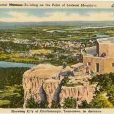
Lookout Mountain, Mountain peak in Walker County, United States

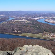
Lookout Mountain is a summit in Walker County, northern Georgia, standing at 729 meters (2,392 feet) above sea level. The ridge forms a natural border between surrounding valleys and extends for several miles along the Tennessee boundary.

During the Civil War, Confederate forces used the summit as an observation post to monitor Union movements in the Tennessee Valley below. Several skirmishes took place around the area, and control of the peak shifted between forces from 1863 to 1864.

Local residents gather annually at the mountain's base for traditional spring festivals that celebrate the regional heritage through music and crafts.

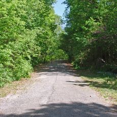
Several marked trails lead up to the summit, with parking available at the main trailheads. Information boards along the routes show details about local wildlife and plant life, and provide guidance for navigating the terrain.

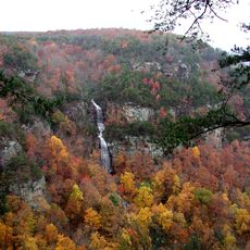
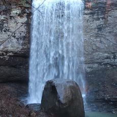
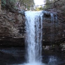
The rock formation contains limestone caves and underground streams that host rare plant species adapted to low-light conditions. These hidden systems remain out of sight for most visitors but significantly influence the moisture and vegetation patterns on the slopes.

The community of curious travelers

AroundUs brings together thousands of curated places, local tips, and hidden gems, enriched daily by 60,000 contributors worldwide.

Start exploring
Location
Elevation above the sea
729 m
GPS coordinates
34.86371,-85.39245
Latest update
December 12, 2025 23:10
Around this place
Ruby Falls
United States of America

Ruby Falls

18 km
Rock City
United States of America

Rock City

12.9 km
Cloudland Canyon State Park
United States of America

Cloudland Canyon State Park

8.7 km
Wilder Brigade Monument
United States of America

Wilder Brigade Monument

12 km
Fort Oglethorpe
United States of America

Fort Oglethorpe

14.9 km
John Ross House
United States of America

John Ross House

16.3 km
Cannon Ball
United States of America

Cannon Ball

18 km
Hemlock Falls
United States of America

Hemlock Falls

8.8 km
International Towing and Recovery Hall of Fame and Museum
United States of America

International Towing and Recovery Hall of Fame and Museum

18.2 km
Gordon-Lee Mansion
United States of America

Gordon-Lee Mansion

9 km
Cherokee Falls
United States of America

Cherokee Falls

9 km
Marsh-Warthen House
United States of America

Marsh-Warthen House

20 km
Lee and Gordon Mill
United States of America

Lee and Gordon Mill

11.7 km
Chickamauga Coal and Iron Company Coke Ovens
United States of America

Chickamauga Coal and Iron Company Coke Ovens

9.1 km
Kelly's Ferry Cemetery
United States of America

Kelly's Ferry Cemetery

19.5 km
Wauhatchie Pike
United States of America

Wauhatchie Pike

18 km
Chickamauga Lodge No. 221, Free and Accepted Masons, Prince Hall Affiliate
United States of America

Chickamauga Lodge No. 221, Free and Accepted Masons, Prince Hall Affiliate

8 km
Chattooga Academy
United States of America

Chattooga Academy

20.1 km
Chickamauga Historic District
United States of America

Chickamauga Historic District

9 km
Dade County Courthouse
United States of America

Dade County Courthouse

10.7 km
US Post Office-Rossville Main
United States of America

US Post Office-Rossville Main

16.4 km
Ochs Memorial Museum
United States of America

Ochs Memorial Museum

17.2 km
Lee & Gordon's Mills
United States of America

Lee & Gordon's Mills

11.7 km
Moccasin Bend
United States of America

Moccasin Bend

19.8 km
Chickamauga Battlefield Visitor Center
United States of America

Chickamauga Battlefield Visitor Center

14.8 km
Mars Theatre
United States of America

Mars Theatre

20 km
Lookout Mountain Battlefield Visitor Center
United States of America

Lookout Mountain Battlefield Visitor Center

16.8 km
Walker County African American Museum
United States of America

Walker County African American Museum

20 km
Show the full map
Reviews
Share your experience

No review yet

Discussions
Start a discussion...

No discussion yet

« Lookout Mountain - Mountain peak in Walker County, United States » is provided by Around Us (aroundus.com). Images and texts are derived from Wikimedia project under a Creative Commons license. You are allowed to copy, distribute, and modify copies of this page, under the conditions set by the license, as long as this note is clearly visible.

Discover hidden gems everywhere you go!

From secret cafés to breathtaking viewpoints, skip the crowded tourist spots and find places that match your style. Our app makes it easy with voice search, smart filtering, route optimization, and insider tips from travelers worldwide. Download now for the complete mobile experience.

Around Us App Screenshot

A unique approach to discovering new places

Le Figaro

All the places worth exploring

France Info

A tailor-made excursion in just a few clicks

20 Minutes

Around Us
Travel Guide & Maps
Download

Send to your phone

QR Code
1

Open the camera app on your mobile.

2

Point at the QR code with your camera. A notification will appear.

3

Tap the notification to open the link.