Chest opened
+${chestReward.xp} XP
Explorer
NOUVEAU ×${chestReward.collectible.quantity}
tapez pour fermer
Chest locked

Open chests in the app

Around Us is built for your phone — chests unlock when you walk, explore and capture nearby places.

Enable Location

We need your location to show you interesting places around you

Discover nearby places

Find interesting locations and hidden gems around you

Precise directions

Get accurate directions and distances to places

Your location is never shared with other users. It's only used when you tap the location button.

Kearney

Log in to your account

Start exploring — it's free

Trusted by 72,878 travelers worldwide

Continue with Google
Continue with Apple
or

We will send you a code to connect

By continuing, you accept our Terms and Conditions and our Privacy Policy

Check your inbox

We've sent a pincode in your inbox. Please enter the code below.

Discussion Reviews 1 Photos
25.5k Popularity

Kearney, Historical city in Clay County, Missouri

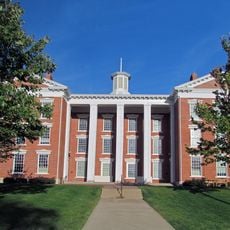
Kearney is a city in Clay County, Missouri, situated on the edge of the Kansas City metropolitan region. The town center features buildings from the 1800s, with residential neighborhoods and farmland spreading around it.

The settlement was founded in 1856 and was initially called Centerville before being officially renamed Kearney in 1869. This renaming marked a new chapter for the growing community.

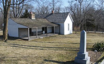
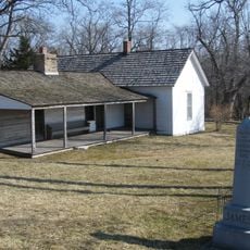
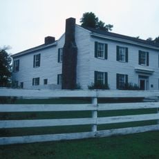
The Jesse James Birthplace Museum occupies the original family home and shapes how locals and visitors understand the town's connection to this 19th-century figure. The house itself remains a focal point for those curious about frontier history.

The city sits along several highways that make it easy to reach other places in the region. Visitors should plan to have a car since most facilities are spread throughout town.

The September festival brings together rides, local food vendors, and entertainment that reflect the town's connection to its most famous historical figure. The event draws both locals and travelers year after year.

The community of curious travelers

AroundUs brings together thousands of curated places, local tips, and hidden gems, enriched daily by 60,000 contributors worldwide.

Start exploring
Location
Inception
1856
Elevation above the sea
261 m
GPS coordinates
39.36580,-94.36030
Latest update
December 16, 2025 12:34
Around this place
Elms Hotel
United States of America

Elms Hotel

12 km
Watkins Woolen Mill State Park and State Historic Site
United States of America

Watkins Woolen Mill State Park and State Historic Site

9.5 km
James Brothers' House and Farm
United States of America

James Brothers' House and Farm

4.5 km
Hall of Waters
United States of America

Hall of Waters

12.2 km
Clay County Savings Association Building
United States of America

Clay County Savings Association Building

14.1 km
Wyman School
United States of America

Wyman School

11.6 km
Mt. Memorial Cemetery
United States of America

Mt. Memorial Cemetery

13.8 km
Jewell Hall
United States of America

Jewell Hall

14 km
Claybrook House
United States of America

Claybrook House

3.3 km
First Methodist Church
United States of America

First Methodist Church

12 km
Ligon Apartments
United States of America

Ligon Apartments

12.2 km
Excelsior Springs Hall of Waters Commercial East Historic District
United States of America

Excelsior Springs Hall of Waters Commercial East Historic District

12.2 km
Garrison School Historic District
United States of America

Garrison School Historic District

13.5 km
Frank Hughes Memorial Library
United States of America

Frank Hughes Memorial Library

14.1 km
United States of America

Colonial Hotel

12.3 km
Excelsior Springs Hall of Waters Commercial West Historic District
United States of America

Excelsior Springs Hall of Waters Commercial West Historic District

10.9 km
United States of America

Watkins Mill Lake

9.3 km
MariMack Golf Complex
United States of America

MariMack Golf Complex

955 m
Watkins Mill Beach
United States of America

Watkins Mill Beach

9.5 km
United States of America

Jewell Disc Golf Course

13.3 km
United States of America

Jewell Theatre Company

13.8 km
United States of America

Amphitheater

9.5 km
United States of America

Kearney Amphitheater

3.6 km
United States of America

Cardinal Hill Golf Course

12.2 km
United States of America

Historic Rush Creek Campground

13.7 km
United States of America

Work of art, sculpture

13.7 km
United States of America

Work of art, sculpture

13.9 km
United States of America

Tryst Falls

7.5 km
Show the full map
Reviews
Share your experience

No review yet

Discussions
Start a discussion...

No discussion yet

« Kearney - Historical city in Clay County, Missouri » is provided by Around Us (aroundus.com). Images and texts are derived from Wikimedia project under a Creative Commons license. You are allowed to copy, distribute, and modify copies of this page, under the conditions set by the license, as long as this note is clearly visible.

Discover hidden gems everywhere you go!

From secret cafés to breathtaking viewpoints, skip the crowded tourist spots and find places that match your style. Our app makes it easy with voice search, smart filtering, route optimization, and insider tips from travelers worldwide. Download now for the complete mobile experience.

Around Us App Screenshot

A unique approach to discovering new places

Le Figaro

All the places worth exploring

France Info

A tailor-made excursion in just a few clicks

20 Minutes

Around Us
Travel Guide & Maps
Download

Send to your phone

QR Code
1

Open the camera app on your mobile.

2

Point at the QR code with your camera. A notification will appear.

3

Tap the notification to open the link.