Chest opened
+${chestReward.xp} XP
Explorer
NOUVEAU ×${chestReward.collectible.quantity}
tapez pour fermer
Chest locked

Open chests in the app

Around Us is built for your phone — chests unlock when you walk, explore and capture nearby places.

Enable Location

We need your location to show you interesting places around you

Discover nearby places

Find interesting locations and hidden gems around you

Precise directions

Get accurate directions and distances to places

Your location is never shared with other users. It's only used when you tap the location button.

Dyersville

Log in to your account

Start exploring — it's free

Trusted by 72,891 travelers worldwide

Continue with Google
Continue with Apple
or

We will send you a code to connect

By continuing, you accept our Terms and Conditions and our Privacy Policy

Check your inbox

We've sent a pincode in your inbox. Please enter the code below.

Discussion Reviews 1 Photos
35.9k Popularity

Dyersville, Agricultural community in eastern Iowa, United States

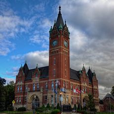
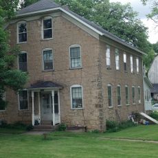
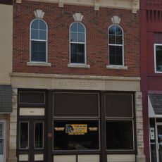
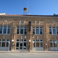
Dyersville is a city located in Delaware and Dubuque counties in eastern Iowa at an elevation of roughly 290 meters. The town center features typical Main Street retail stores and residential neighborhoods that cluster around the downtown area.

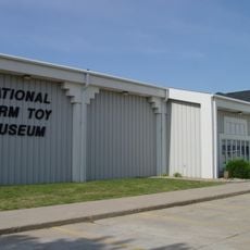
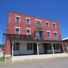
James Dyer, an English settler, founded the town in 1851 and opened the Clarendon Hotel, which became a gathering place for the community. The settlement grew into a center for farm toy manufacturing, building on agricultural traditions that defined the region.

The Farm Toy Show draws collectors and enthusiasts from around the world each year to buy and sell miniature farm equipment. This annual gathering reflects how deeply toy farming fits into local identity and community pride.

The town is fairly flat and easy to navigate on foot, with clear streets spreading out from the downtown area. Walking works well if you want to explore local shops and get a sense of the community layout.

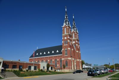
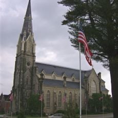
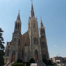
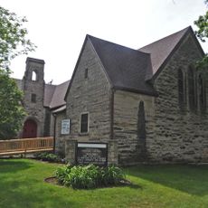
The Basilica of St. Francis Xavier sits unexpectedly in this farm community and is one of the few Roman Catholic basilicas built in a rural American setting. Its grand architecture stands out sharply against the surrounding farmland.

The community of curious travelers

AroundUs brings together thousands of curated places, local tips, and hidden gems, enriched daily by 60,000 contributors worldwide.

Start exploring
Location
Inception
1851
Elevation above the sea
290 m
GPS coordinates
42.48139,-91.12083
Latest update
December 17, 2025 11:21
Around this place
New Melleray Abbey
United States of America

New Melleray Abbey

27.5 km
Driftless Area National Wildlife Refuge
United States of America

Driftless Area National Wildlife Refuge

22.5 km
National Farm Toy Museum
United States of America

National Farm Toy Museum

1.5 km
Nelson Dewey State Park
United States of America

Nelson Dewey State Park

29 km
Stonefield
United States of America

Stonefield

29.3 km
Fountain Springs Park
United States of America

Fountain Springs Park

20.9 km
Saint Boniface Church
United States of America

Saint Boniface Church

7.7 km
Saints Peter and Paul Church
United States of America

Saints Peter and Paul Church

11.2 km
Delaware County Courthouse
United States of America

Delaware County Courthouse

26.4 km
St. Patrick's Church-Garryowen
United States of America

St. Patrick's Church-Garryowen

31.3 km
Haberkorn House and Farmstead
United States of America

Haberkorn House and Farmstead

28.2 km
Ely's Stone Bridge
United States of America

Ely's Stone Bridge

26.5 km
St. Luke's Methodist Church
United States of America

St. Luke's Methodist Church

27.4 km
Denniston House
United States of America

Denniston House

27.9 km
Dunleith and Dubuque Bridge
United States of America

Dunleith and Dubuque Bridge

28.3 km
Lincoln Elementary School
United States of America

Lincoln Elementary School

28.1 km
Bay Settlement Church and Monument
United States of America

Bay Settlement Church and Monument

23.3 km
Round Barn, Millville Township
United States of America

Round Barn, Millville Township

26.2 km
Sherrill Mount House
United States of America

Sherrill Mount House

30.7 km
Allen House
United States of America

Allen House

867 m
J.J. Hoag House
United States of America

J.J. Hoag House

27.6 km
S.S. Farwell House
United States of America

S.S. Farwell House

27 km
Odd Fellows Hall
United States of America

Odd Fellows Hall

27.7 km
Zephaniah Kidder House
United States of America

Zephaniah Kidder House

16.2 km
Sauser-Lane House
United States of America

Sauser-Lane House

22.3 km
Ruth Suckow House
United States of America

Ruth Suckow House

12 km
Memorial Building
United States of America

Memorial Building

384 m
James Kennedy Public Library
United States of America

James Kennedy Public Library

361 m
Show the full map
Reviews
Share your experience

No review yet

Discussions
Start a discussion...

No discussion yet

« Dyersville - Agricultural community in eastern Iowa, United States » is provided by Around Us (aroundus.com). Images and texts are derived from Wikimedia project under a Creative Commons license. You are allowed to copy, distribute, and modify copies of this page, under the conditions set by the license, as long as this note is clearly visible.

Discover hidden gems everywhere you go!

From secret cafés to breathtaking viewpoints, skip the crowded tourist spots and find places that match your style. Our app makes it easy with voice search, smart filtering, route optimization, and insider tips from travelers worldwide. Download now for the complete mobile experience.

Around Us App Screenshot

A unique approach to discovering new places

Le Figaro

All the places worth exploring

France Info

A tailor-made excursion in just a few clicks

20 Minutes

Around Us
Travel Guide & Maps
Download

Send to your phone

QR Code
1

Open the camera app on your mobile.

2

Point at the QR code with your camera. A notification will appear.

3

Tap the notification to open the link.