Enable Location

We need your location to show you interesting places around you

Discover nearby places

Find interesting locations and hidden gems around you

Precise directions

Get accurate directions and distances to places

Your location is never shared with other users. It's only used when you tap the location button.

Claysville S Bridge

Log in to your account

Start exploring — it's free

Trusted by 61,681 travelers worldwide

Continue with Google
Continue with Apple
or

We will send you a code to connect

By continuing, you accept our Terms and Conditions and our Privacy Policy

Check your inbox

We've sent a pincode in your inbox. Please enter the code below.

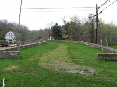
Claysville S Bridge, Stone footbridge in Buffalo Township, United States.

Description

Claysville S Bridge is a stone arch structure that crosses Buffalo Creek using building methods from the early 1800s. The bridge features stonework arches and support piers that were constructed to handle regular foot traffic over the waterway.

History

The bridge was built in 1818 and formed part of the Cumberland Road, a major route for wagons and coaches during westward expansion in America. It came into existence during a time when such crossings were needed to open new travel routes.

Culture

Visitors can see how local craftsmen built this stone bridge using techniques that depended on skill and experience rather than machinery. The structure shows how communities once solved practical problems through careful stonework and engineering knowledge passed down from earlier builders.

Practical

The bridge is located in Buffalo Township and is accessible on foot from the nearest parking area. Visitors should be careful when walking, especially during wet or icy weather, since the structure is quite old.

Did you know?

The structure gained recognition on the National Register of Historic Places in 1975, confirming its importance as an engineering work. This honor highlighted that the construction was noteworthy for both its era and its craftsmanship.

Location
Inception
1818
GPS coordinates
40.13944,-80.35000
Latest update
December 14, 2025 13:02

AroundUs brings together thousands of curated places, local tips, and hidden gems, enriched daily by 60,000 contributors worldwide. Discover all places nearby (Buffalo Township).

Around this place
Pennsylvania Trolley Museum
United States of America

Pennsylvania Trolley Museum

11.1 km
F. Julius LeMoyne House
United States of America

F. Julius LeMoyne House

9.6 km
LeMoyne Crematory
United States of America

LeMoyne Crematory

9.8 km
David Bradford House
United States of America

David Bradford House

9.5 km
Cameron Stadium
United States of America

Cameron Stadium

9.3 km
Washington County Courthouse
United States of America

Washington County Courthouse

9.5 km
Washington County Jail
United States of America

Washington County Jail

9.5 km
Church of the Covenant
United States of America

Church of the Covenant

10.1 km
Beth Israel Congregation
United States of America

Beth Israel Congregation

10.6 km
Old Main
United States of America

Old Main

9.9 km
U. Grant Miller Library
United States of America

U. Grant Miller Library

9.9 km
First Presbyterian Church
United States of America

First Presbyterian Church

9.8 km
East Washington Historic District
United States of America

East Washington Historic District

10.5 km
Hays Hall
United States of America

Hays Hall

9.8 km
Technology Center
United States of America

Technology Center

10.1 km
Montgomery House
United States of America

Montgomery House

6.2 km
The Burnett Center
United States of America

The Burnett Center

10.1 km
Sawhill Covered Bridge
United States of America

Sawhill Covered Bridge

7.2 km
Dr. Joseph Maurer House
United States of America

Dr. Joseph Maurer House

9.3 km
John White House
United States of America

John White House

11 km
Caldwell Tavern
United States of America

Caldwell Tavern

10.9 km
Scott Brownlee Covered Bridge
United States of America

Scott Brownlee Covered Bridge

11.4 km
Taylorstown Historic District
United States of America

Taylorstown Historic District

3.4 km
Danley Covered Bridge
United States of America

Danley Covered Bridge

12.1 km
Blaney Mays Covered Bridge
United States of America

Blaney Mays Covered Bridge

13 km
Margaret Derrow House
United States of America

Margaret Derrow House

6.2 km
Pennsylvania Trolley Museum
United States of America

Pennsylvania Trolley Museum

11.9 km
Uptown Theatre
United States of America

Uptown Theatre

9.6 km
Show the full map
« Claysville S Bridge - Stone footbridge in Buffalo Township, United States » is provided by Around Us (aroundus.com). Images and texts are derived from Wikimedia project under a Creative Commons license. You are allowed to copy, distribute, and modify copies of this page, under the conditions set by the license, as long as this note is clearly visible.

Discover hidden gems everywhere you go!

From secret cafés to breathtaking viewpoints, skip the crowded tourist spots and find places that match your style. Our app makes it easy with voice search, smart filtering, route optimization, and insider tips from travelers worldwide. Download now for the complete mobile experience.

Around Us App Screenshot

A unique approach to discovering new places

Le Figaro

All the places worth exploring

France Info

A tailor-made excursion in just a few clicks

20 Minutes

Around Us
Travel Guide & Maps
Download

Send to your phone

QR Code
1

Open the camera app on your mobile.

2

Point at the QR code with your camera. A notification will appear.

3

Tap the notification to open the link.