Cedarburg Covered Bridge

Log in to your account

AroundUs is a community-driven map of interesting places, built by curious explorers like you. It grows with every review, story, and photo you share.
Connect to save your favorite spots, contribute locations, and create personalized routes.
Continue with Google
Continue with Apple
Continue with X
Continue with Facebook
Continue with email
By continuing, you accept our Terms and Conditions and our Privacy Policy
Create an account
Add to collection
Map
Suggest a change
Share

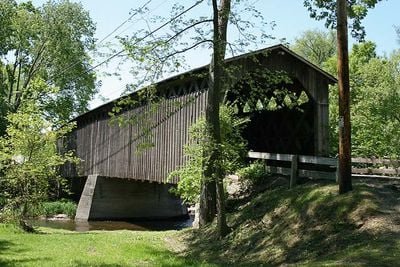
Cedarburg Covered Bridge, Covered bridge in Cedarburg, United States.

Cedarburg Covered Bridge is a wooden structure spanning Cedar Creek, constructed from pine and oak timbers joined with traditional framing methods. The design incorporates wooden pegs rather than metal fasteners to hold the timber components together.

Local farmers requested construction in 1876 after previous structures had been destroyed by repeated flooding of Cedar Creek in the area. The timber design reflected building methods that communities across the region had proven effective for crossing water obstacles.

The bridge stands as a symbol of how the community solved transportation challenges in earlier times, showing visitors how engineering adapted to local geography. Today people gather here to appreciate the craftsmanship and understand what daily crossing meant to past generations.

The structure sits within Covered Bridge Park, which offers picnic areas and basic facilities for spending time outdoors. Visitors can approach the bridge from several points and enjoy the surroundings on foot, with plenty of space to observe the wooden construction up close.

The structure was relocated about 50 feet east in 1962 to preserve its condition while a modern bridge took over vehicle traffic responsibilities. This unusual move shows how communities chose to protect timber structures by changing their role rather than replacing them entirely.

Location: Cedarburg

Inception: 1876

Made from material: oakwood, pine

GPS coordinates: 43.33750,-88.00500

Latest update: December 12, 2025 09:08

Photos
Around this place
Lion's Den Gorge Nature Preserve
United States of America

Lion's Den Gorge Nature Preserve

9.6 km
St. Mary's Roman Catholic Church
United States of America

St. Mary's Roman Catholic Church

12.5 km
Washington Avenue Historic District
United States of America

Washington Avenue Historic District

4.4 km
Cedarburg Mill
United States of America

Cedarburg Mill

4.8 km
Port Washington Light
United States of America

Port Washington Light

12.6 km
Grafton Flour Mill
United States of America

Grafton Flour Mill

5 km
United States of America

Kevich Light

9.6 km
St. Augustine Catholic Church and Cemetery
United States of America

St. Augustine Catholic Church and Cemetery

6 km
Port Washington Downtown Historic District
United States of America

Port Washington Downtown Historic District

12.4 km
Jonathan Clark House
United States of America

Jonathan Clark House

8.1 km
John Reichert Farmhouse
United States of America

John Reichert Farmhouse

7.1 km
Cedarburg Bog
United States of America

Cedarburg Bog

5.5 km
Old Ozaukee County Courthouse
United States of America

Old Ozaukee County Courthouse

12.2 km
Concordia Mill
United States of America

Concordia Mill

6.5 km
Wayside House
United States of America

Wayside House

5.3 km
Edward Dodge House
United States of America

Edward Dodge House

12.3 km
Christian Turck House
United States of America

Christian Turck House

9.6 km
Edwin J. Nieman Sr. House
United States of America

Edwin J. Nieman Sr. House

9.2 km
Isham Day House
United States of America

Isham Day House

12.8 km
William F. Jahn Farmstead
United States of America

William F. Jahn Farmstead

11 km
Bigelow School
United States of America

Bigelow School

8.7 km
Cedarburg Woolen Co. Worsted Mill
United States of America

Cedarburg Woolen Co. Worsted Mill

5.1 km
Columbia Historic District
United States of America

Columbia Historic District

4.7 km
Harry W. Bolens House
United States of America

Harry W. Bolens House

11 km
Main Street Historic District
United States of America

Main Street Historic District

12.2 km
Green Bay Road Historic District
United States of America

Green Bay Road Historic District

12 km
Jacob Voigt House
United States of America

Jacob Voigt House

12.2 km
Pirates' Hollow Waterpark
United States of America

Pirates' Hollow Waterpark

11.8 km
Show the full map
Reviews

Visited this place? Tap the stars to rate it and share your experience / photos with the community! Try now! You can cancel it anytime.

« Cedarburg Covered Bridge - Covered bridge in Cedarburg, United States » is provided by Around Us (aroundus.com). Images and texts are derived from Wikimedia project under a Creative Commons license. You are allowed to copy, distribute, and modify copies of this page, under the conditions set by the license, as long as this note is clearly visible.

Discover hidden gems everywhere you go!

From secret cafés to breathtaking viewpoints, skip the crowded tourist spots and find places that match your style. Our app makes it easy with voice search, smart filtering, route optimization, and insider tips from travelers worldwide. Download now for the complete mobile experience.

Around Us App Screenshot

A unique approach to discovering new places

Le Figaro

All the places worth exploring

France Info

A tailor-made excursion in just a few clicks

20 Minutes