Chest opened
+${chestReward.xp} XP
Explorer
NOUVEAU ×${chestReward.collectible.quantity}
tapez pour fermer
Chest locked

Open chests in the app

Around Us is built for your phone — chests unlock when you walk, explore and capture nearby places.

Enable Location

We need your location to show you interesting places around you

Discover nearby places

Find interesting locations and hidden gems around you

Precise directions

Get accurate directions and distances to places

Your location is never shared with other users. It's only used when you tap the location button.

Rickenbacker International Airport

Log in to your account

Start exploring — it's free

Trusted by 73,101 travelers worldwide

Continue with Google
Continue with Apple
or

We will send you a code to connect

By continuing, you accept our Terms and Conditions and our Privacy Policy

Check your inbox

We've sent a pincode in your inbox. Please enter the code below.

Discussion Reviews 2 Photos
51.3k Popularity

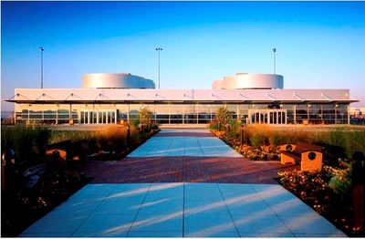
Rickenbacker International Airport, International airport in Franklin County, Ohio, United States

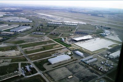
Rickenbacker International Airport is a commercial facility in Franklin County that handles both civilian and military aircraft operations with a focus on cargo transportation. Two runways serve cargo carriers, passenger charter flights, and government aviation needs in the region.

The facility opened in June 1942 as Lockbourne Army Airfield, serving as a military training base during World War II. After the war, it transitioned to civilian and military commercial operations under its current name.

The airport is named after Eddie Rickenbacker, a Columbus native who shaped American aviation history as a military pilot. The name honors his role in developing flight as a critical technology.

The airport sits about 10 miles south of downtown Columbus and is straightforward to reach by car from the city. Keep in mind that cargo operations dominate here, so commercial passenger services are limited compared to larger regional hubs.

The airport operates a specialized USDA-certified animal transport center that enables safe and regulated movement of livestock across international borders. This facility makes it a key point for agricultural export logistics in the region.

The community of curious travelers

AroundUs brings together thousands of curated places, local tips, and hidden gems, enriched daily by 60,000 contributors worldwide.

Start exploring
Location
Official opening
1942
Elevation above the sea
227 m
Operator
Columbus Regional Airport Authority
Address
John Cir Dr
GPS coordinates
39.81389,-82.92778
Latest update
December 20, 2025 21:54
Around this place
Fortress Obetz
United States of America

Fortress Obetz

8.3 km
United States of America

Columbus Motor Speedway

8.2 km
Renick Farm
United States of America

Renick Farm

8.9 km
United States of America

Hartman Stock Farm Historic District

7.9 km
Bergstresser/Dietz Covered Bridge
United States of America

Bergstresser/Dietz Covered Bridge

9.7 km
Slate Run Metro Park
United States of America

Slate Run Metro Park

8.8 km
Groveport United Methodist Church
United States of America

Groveport United Methodist Church

5.5 km
David's Reformed Church
United States of America

David's Reformed Church

10.6 km
Perrill-Goodman Farmhouse
United States of America

Perrill-Goodman Farmhouse

4.8 km
Samuel Landes House
United States of America

Samuel Landes House

8.3 km
United States of America

Southland Mall Theatre

10.1 km
United States of America

Scioto Downs Racetrack & Casino

6.5 km
United States of America

Monument featuring aircraft, aircraft model

6.1 km
United States of America

Westchester Golf Course

8.7 km
United States of America

Groveport Municipal Golf Course

5.6 km
United States of America

Amphitheater

7.5 km
United States of America

Scenic viewpoint

8.3 km
United States of America

Scenic viewpoint

7.7 km
United States of America

Scenic viewpoint

6.3 km
United States of America

Monument featuring aircraft, aircraft model

6.1 km
United States of America

The Players Club at Foxfire

10.8 km
United States of America

Aircraft model, monument featuring aircraft

6.1 km
United States of America

Monument featuring aircraft, aircraft model

6.1 km
United States of America

Monument featuring aircraft, aircraft model

6.1 km
United States of America

Cannon

6.1 km
United States of America

Cannon

6.1 km
United States of America

Cannon

6.1 km
United States of America

Vehicle

6.1 km
Show the full map
Reviews
Share your experience

No review yet

Discussions
Start a discussion...

No discussion yet

« Rickenbacker International Airport - International airport in Franklin County, Ohio, United States » is provided by Around Us (aroundus.com). Images and texts are derived from Wikimedia project under a Creative Commons license. You are allowed to copy, distribute, and modify copies of this page, under the conditions set by the license, as long as this note is clearly visible.

Discover hidden gems everywhere you go!

From secret cafés to breathtaking viewpoints, skip the crowded tourist spots and find places that match your style. Our app makes it easy with voice search, smart filtering, route optimization, and insider tips from travelers worldwide. Download now for the complete mobile experience.

Around Us App Screenshot

A unique approach to discovering new places

Le Figaro

All the places worth exploring

France Info

A tailor-made excursion in just a few clicks

20 Minutes

Around Us
Travel Guide & Maps
Download

Send to your phone

QR Code
1

Open the camera app on your mobile.

2

Point at the QR code with your camera. A notification will appear.

3

Tap the notification to open the link.