Chest opened
+${chestReward.xp} XP
Explorer
NOUVEAU ×${chestReward.collectible.quantity}
tapez pour fermer
Chest locked

Open chests in the app

Around Us is built for your phone — chests unlock when you walk, explore and capture nearby places.

Enable Location

We need your location to show you interesting places around you

Discover nearby places

Find interesting locations and hidden gems around you

Precise directions

Get accurate directions and distances to places

Your location is never shared with other users. It's only used when you tap the location button.

Log in to your account

Start exploring — it's free

Trusted by 73,097 travelers worldwide

Continue with Google
Continue with Apple
or

We will send you a code to connect

By continuing, you accept our Terms and Conditions and our Privacy Policy

Check your inbox

We've sent a pincode in your inbox. Please enter the code below.

Hartman Stock Farm Historic District
Discussion Reviews Photo
1.5k Popularity

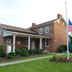
Hartman Stock Farm Historic District, Historic farm district in Columbus, United States

Hartman Stock Farm Historic District is an agricultural area along South High Street with preserved farming structures and buildings. The property contains barns, silos, a foreman's house, dairy facility, a one-room schoolhouse, and other residential structures.

The property was established in 1903 and grew to become one of Ohio's largest working farms. This expansion marked a key moment in how the region transitioned from purely rural land to a developing urban area.

The district shows how farming shaped Columbus and what role agricultural properties once played in the region's identity. Walking through, you can see how the buildings and open spaces tell the story of this rural past.

The site is accessible along a major road, making it easy to view the different buildings from the street. You can explore the layout of the property and get a sense of how the working farm was organized.

The farm once operated its own power plant and canning factory, which was quite advanced for the time. These facilities show how the operation went beyond just growing crops and included food processing on-site.

The community of curious travelers

AroundUs brings together thousands of curated places, local tips, and hidden gems, enriched daily by 60,000 contributors worldwide.

Start exploring
Location
Inception
1903
GPS coordinates
39.85667,-83.00222
Latest update
December 14, 2025 14:41
Around this place
Fortress Obetz
United States of America

Fortress Obetz

5.8 km
Miranova Place
United States of America

Miranova Place

10.9 km
Great Southern Hotel & Theatre
United States of America

Great Southern Hotel & Theatre

11.1 km
Umbrella Girl
United States of America

Umbrella Girl

9.6 km
Main Street Bridge
United States of America

Main Street Bridge

11.1 km
Captain Edward V. Rickenbacker House
United States of America

Captain Edward V. Rickenbacker House

10.9 km
Green Lawn Abbey
United States of America

Green Lawn Abbey

9.4 km
Saint Mary of the Assumption Catholic Church
United States of America

Saint Mary of the Assumption Catholic Church

10.3 km
171-191 South High Street
United States of America

171-191 South High Street

11.3 km
Statue of Benjamin Franklin
United States of America

Statue of Benjamin Franklin

10.9 km
Cultural Arts Center
United States of America

Cultural Arts Center

11 km
Statue of Friedrich Schiller
United States of America

Statue of Friedrich Schiller

9.5 km
Rich Street Bridge
United States of America

Rich Street Bridge

11.2 km
Farm Crest Bakeries building
United States of America

Farm Crest Bakeries building

11.3 km
Hartman Hotel
United States of America

Hartman Hotel

11.2 km
Bellows School
United States of America

Bellows School

10.8 km
A.G. Grant Homestead
United States of America

A.G. Grant Homestead

7.6 km
Gantz Homestead
United States of America

Gantz Homestead

6.9 km
Groveport United Methodist Church
United States of America

Groveport United Methodist Church

10 km
Trautman Building
United States of America

Trautman Building

11.3 km
The Julian
United States of America

The Julian

11.1 km
South High Commercial Historic District
United States of America

South High Commercial Historic District

11 km
Krumm House
United States of America

Krumm House

9.5 km
Del Monte Apartments
United States of America

Del Monte Apartments

11 km
Samuel Landes House
United States of America

Samuel Landes House

2.3 km
Franklin County Courthouse
United States of America

Franklin County Courthouse

10.8 km
Johann Christian Heyl
United States of America

Johann Christian Heyl

10.9 km
Trinity Lutheran Seminary
United States of America

Trinity Lutheran Seminary

10.2 km
Show the full map
Reviews
Share your experience

No review yet

Discussions
Start a discussion...

No discussion yet

« Hartman Stock Farm Historic District - Historic farm district in Columbus, United States » is provided by Around Us (aroundus.com). Images and texts are derived from Wikimedia project under a Creative Commons license. You are allowed to copy, distribute, and modify copies of this page, under the conditions set by the license, as long as this note is clearly visible.

Discover hidden gems everywhere you go!

From secret cafés to breathtaking viewpoints, skip the crowded tourist spots and find places that match your style. Our app makes it easy with voice search, smart filtering, route optimization, and insider tips from travelers worldwide. Download now for the complete mobile experience.

Around Us App Screenshot

A unique approach to discovering new places

Le Figaro

All the places worth exploring

France Info

A tailor-made excursion in just a few clicks

20 Minutes

Around Us
Travel Guide & Maps
Download

Send to your phone

QR Code
1

Open the camera app on your mobile.

2

Point at the QR code with your camera. A notification will appear.

3

Tap the notification to open the link.