Chest opened
+${chestReward.xp} XP
Explorer
NOUVEAU ×${chestReward.collectible.quantity}
tapez pour fermer
Chest locked

Open chests in the app

Around Us is built for your phone — chests unlock when you walk, explore and capture nearby places.

Enable Location

We need your location to show you interesting places around you

Discover nearby places

Find interesting locations and hidden gems around you

Precise directions

Get accurate directions and distances to places

Your location is never shared with other users. It's only used when you tap the location button.

Chesterfield Court House

Log in to your account

Start exploring — it's free

Trusted by 73,102 travelers worldwide

Continue with Google
Continue with Apple
or

We will send you a code to connect

By continuing, you accept our Terms and Conditions and our Privacy Policy

Check your inbox

We've sent a pincode in your inbox. Please enter the code below.

Discussion Reviews 1 Photos
23k Popularity

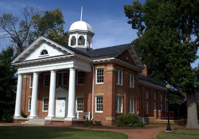
Chesterfield Court House, County seat and census-designated place in Chesterfield County, Virginia

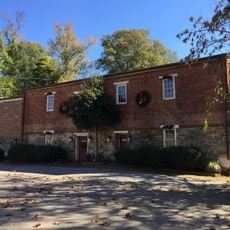
Chesterfield Court House is the governmental center of Chesterfield County, Virginia, housing courts, administrative offices, and related public services across a substantial area. The courthouse building anchors the district alongside modern county offices that serve residents' legal and administrative needs.

The courthouse was established in 1749 as the county's administrative center, though operations relocated to Manchester between 1870 and 1876 during Reconstruction. The facility resumed its original function afterward and has since remained the seat of county government.

The courthouse square remains the focal point where residents gather for official matters and community needs. This layout reflects how Virginia communities organized themselves around a central place of authority and law.

The government offices and courthouse cluster around a central location, making it straightforward to navigate and find services. Plan to spend time here, as the buildings handle significant county business and can be busy during normal business hours.

The courthouse square has maintained its role as county seat for over two centuries, even while surrounding areas developed dramatically with suburban growth. Few places in the region have preserved such continuity of purpose and location.

The community of curious travelers

AroundUs brings together thousands of curated places, local tips, and hidden gems, enriched daily by 60,000 contributors worldwide.

Start exploring
Elevation above the sea
60 m
GPS coordinates
37.37779,-77.50467
Latest update
December 20, 2025 15:09
Around this place
Henricus
United States of America

Henricus

12.6 km
Varina Farms
United States of America

Varina Farms

14.9 km
Pocahontas State Park
United States of America

Pocahontas State Park

5.9 km
Varina-Enon Bridge
United States of America

Varina-Enon Bridge

14 km
Chimborazo Park
United States of America

Chimborazo Park

12.9 km
Dutch Gap
United States of America

Dutch Gap

13.2 km
Uptown Alley
United States of America

Uptown Alley

11.7 km
Fort Darling
United States of America

Fort Darling

8.4 km
United States of America

Henrico City

14.9 km
Cracker Barrel
United States of America

Cracker Barrel

12.8 km
Fort Harrison National Cemetery
United States of America

Fort Harrison National Cemetery

13.4 km
Magnolia Grange
United States of America

Magnolia Grange

399 m
Bridge at Falling Creek
United States of America

Bridge at Falling Creek

9 km
Beach Station
United States of America

Beach Station

8.4 km
American Tobacco Company, South Richmond Complex Historic District
United States of America

American Tobacco Company, South Richmond Complex Historic District

15.4 km
Swift Creek Rail Bridge
United States of America

Swift Creek Rail Bridge

3.1 km
Swift Creek Mill
United States of America

Swift Creek Mill

13.4 km
Chesterfield County Government Complex
United States of America

Chesterfield County Government Complex

11 m
Proctor Creek, Jefferson Davis Highway Marker
United States of America

Proctor Creek, Jefferson Davis Highway Marker

6.9 km
Farmer's Rest
United States of America

Farmer's Rest

13.8 km
Laurel Meadow
United States of America

Laurel Meadow

12 km
Blair Tobacco Storage Warehouse Complex Historic District
United States of America

Blair Tobacco Storage Warehouse Complex Historic District

15.3 km
The Village Grill
United States of America

The Village Grill

5.6 km
Hatcher Island Bridge
United States of America

Hatcher Island Bridge

11.6 km
Victory Theater
United States of America

Victory Theater

13.6 km
North Courthouse Road
United States of America

North Courthouse Road

14.5 km
Clover Hill Library
United States of America

Clover Hill Library

13.8 km
Varina Area Library
United States of America

Varina Area Library

14.2 km
Show the full map
Reviews
Share your experience

No review yet

Discussions
Start a discussion...

No discussion yet

« Chesterfield Court House - County seat and census-designated place in Chesterfield County, Virginia » is provided by Around Us (aroundus.com). Images and texts are derived from Wikimedia project under a Creative Commons license. You are allowed to copy, distribute, and modify copies of this page, under the conditions set by the license, as long as this note is clearly visible.

Discover hidden gems everywhere you go!

From secret cafés to breathtaking viewpoints, skip the crowded tourist spots and find places that match your style. Our app makes it easy with voice search, smart filtering, route optimization, and insider tips from travelers worldwide. Download now for the complete mobile experience.

Around Us App Screenshot

A unique approach to discovering new places

Le Figaro

All the places worth exploring

France Info

A tailor-made excursion in just a few clicks

20 Minutes

Around Us
Travel Guide & Maps
Download

Send to your phone

QR Code
1

Open the camera app on your mobile.

2

Point at the QR code with your camera. A notification will appear.

3

Tap the notification to open the link.