Enable Location

We need your location to show you interesting places around you

Discover nearby places

Find interesting locations and hidden gems around you

Precise directions

Get accurate directions and distances to places

Your location is never shared with other users. It's only used when you tap the location button.

Mull Covered Bridge

Log in to your account

Start exploring — it's free

Trusted by 63,015 travelers worldwide

Continue with Google
Continue with Apple
or

We will send you a code to connect

By continuing, you accept our Terms and Conditions and our Privacy Policy

Check your inbox

We've sent a pincode in your inbox. Please enter the code below.

Discussion Reviews 1 Photos
1.3k Popularity

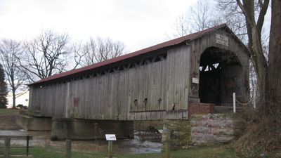
Mull Covered Bridge, Wooden covered bridge in Ballville Township, United States.

Mull Covered Bridge is a wooden structure crossing Wolf Creek, built using a Town Lattice truss design with diagonal bracing elements. The bridge rests on stone abutments and features vertical wooden siding protected by a metal roof.

Built in 1851, the bridge served the Mull family and provided critical access to the local mill. It remained active for vehicle traffic until 1962, after which its use became more restricted.

The bridge reflects a period when covered structures protected wooden frameworks from weather damage. Visitors can observe the traditional craftsmanship in the vertical wooden walls and the practical design choices of that era.

The structure is accessible from ground level and can be photographed from outside. Before visiting, it is helpful to contact the Sandusky County Commissioners Office to confirm current access conditions and any seasonal considerations.

This bridge remains one of the few surviving covered bridges in Northwest Ohio and has undergone significant restoration work. The major repairs completed in the 1990s and 2010s were crucial in preserving the structure for future generations.

The community of curious travelers

AroundUs brings together thousands of curated places, local tips, and hidden gems, enriched daily by 60,000 contributors worldwide.

Start exploring
Inception
1851
GPS coordinates
41.26080,-83.18440
Latest update
December 14, 2025 18:12
Around this place
Spiegel Grove
United States of America

Spiegel Grove

10 km
Rutherford B. Hayes Presidential Center
United States of America

Rutherford B. Hayes Presidential Center

10.1 km
Edison Bridge
United States of America

Edison Bridge

38.1 km
Seneca Caverns
United States of America

Seneca Caverns

26.2 km
Fort Stephenson
United States of America

Fort Stephenson

11.1 km
Sandusky County Jail and Sheriff's House
United States of America

Sandusky County Jail and Sheriff's House

11.1 km
Wood County Museum
United States of America

Wood County Museum

37.5 km
John Wright Mansion
United States of America

John Wright Mansion

33.1 km
Erie Proving Ground
United States of America

Erie Proving Ground

33.3 km
Port Clinton Light
United States of America

Port Clinton Light

35.2 km
The Octagon
United States of America

The Octagon

16.1 km
Old School Privy
United States of America

Old School Privy

31.8 km
Overmyer–Waggoner–Roush Farm
United States of America

Overmyer–Waggoner–Roush Farm

17.1 km
Frederick Fabing House
United States of America

Frederick Fabing House

11 km
Joseph and Rachel Bartlett House
United States of America

Joseph and Rachel Bartlett House

10.9 km
Soldiers and McKinley Memorial Parkways
United States of America

Soldiers and McKinley Memorial Parkways

9.8 km
Sandusky County Courthouse
United States of America

Sandusky County Courthouse

11.1 km
Bagby-Hossler House
United States of America

Bagby-Hossler House

17.6 km
Aigler Alumni Building
United States of America

Aigler Alumni Building

16.1 km
Pleasant Ridge United Methodist Church and Cemetery
United States of America

Pleasant Ridge United Methodist Church and Cemetery

12.5 km
United States of America

Black Student Union Center

16.4 km
Georg Cronenwett House
United States of America

Georg Cronenwett House

26.4 km
Fostoria Iron Triangle Rail Park
United States of America

Fostoria Iron Triangle Rail Park

22.3 km
Historic Lyme Village & Museum with The John Wright Victorian Mansion
United States of America

Historic Lyme Village & Museum with The John Wright Victorian Mansion

33.1 km
Paramount Cinema
United States of America

Paramount Cinema

11 km
Fostoria Mausoleum
United States of America

Fostoria Mausoleum

23 km
Early Electric Illumination, 1884
United States of America

Early Electric Illumination, 1884

16.4 km
Mad River and Lake Erie Railroad
United States of America

Mad River and Lake Erie Railroad

15.8 km
Show the full map
Reviews
Share your experience

No review yet

Discussions
Start a discussion...

No discussion yet

« Mull Covered Bridge - Wooden covered bridge in Ballville Township, United States » is provided by Around Us (aroundus.com). Images and texts are derived from Wikimedia project under a Creative Commons license. You are allowed to copy, distribute, and modify copies of this page, under the conditions set by the license, as long as this note is clearly visible.

Discover hidden gems everywhere you go!

From secret cafés to breathtaking viewpoints, skip the crowded tourist spots and find places that match your style. Our app makes it easy with voice search, smart filtering, route optimization, and insider tips from travelers worldwide. Download now for the complete mobile experience.

Around Us App Screenshot

A unique approach to discovering new places

Le Figaro

All the places worth exploring

France Info

A tailor-made excursion in just a few clicks

20 Minutes

Around Us
Travel Guide & Maps
Download

Send to your phone

QR Code
1

Open the camera app on your mobile.

2

Point at the QR code with your camera. A notification will appear.

3

Tap the notification to open the link.