Enable Location

We need your location to show you interesting places around you

Discover nearby places

Find interesting locations and hidden gems around you

Precise directions

Get accurate directions and distances to places

Your location is never shared with other users. It's only used when you tap the location button.

Fort Corchaug Archaeological Site

Log in to your account

Start exploring — it's free

Trusted by 61,823 travelers worldwide

Continue with Google
Continue with Apple
or

We will send you a code to connect

By continuing, you accept our Terms and Conditions and our Privacy Policy

Check your inbox

We've sent a pincode in your inbox. Please enter the code below.

Fort Corchaug Archaeological Site, Archaeological site in Southold, United States.

Description

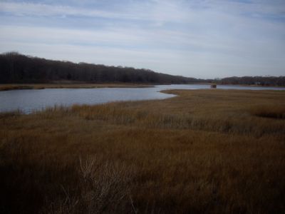
Fort Corchaug Archaeological Site is an excavation area on 105 acres of protected land on eastern Long Island that contains the remains of a log fort built by Native Americans. The grounds reveal the physical traces of a former settlement with visible fortification patterns and layers from different periods.

History

The fort was built in the 17th century by the Corchaug people with European support as a defense against rival tribes in the region. This construction marked a turning point when local defense strategies shifted toward fortified settlements.

Culture

The Corchaug people built this fortified settlement with European help, showing how indigenous and colonial communities interacted in early Long Island. Walking through the preserved grounds, you can sense how two very different worlds came together to shape this place.

Practical

The site is accessible through nature trails that connect to the adjacent Downs Farm Preserve, allowing visitors to explore at a relaxed pace. Wear comfortable shoes and plan enough time to properly walk the grounds, as the excavation areas are spread across a sizable landscape.

Did you know?

This location is one of the few remaining undisturbed Native American fortified village sites in the northeastern United States where the original settlement pattern is still visible. The preservation of the archaeological layers allows researchers and visitors to understand the settlement history in unusual completeness.

Location
GPS coordinates
41.00268,-72.49874
Latest update
December 14, 2025 16:46

AroundUs brings together thousands of curated places, local tips, and hidden gems, enriched daily by 60,000 contributors worldwide. Discover all places nearby (Southold).

Around this place
Shinnecock Hills Golf Club
United States of America

Shinnecock Hills Golf Club

12.9 km
National Golf Links of America
United States of America

National Golf Links of America

11.1 km
Old House
United States of America

Old House

1.2 km
The Watermill Center
United States of America

The Watermill Center

14.6 km
Elizabeth A. Morton National Wildlife Refuge
United States of America

Elizabeth A. Morton National Wildlife Refuge

10.8 km
Horton Point Light
United States of America

Horton Point Light

10.2 km
Conscience Point National Wildlife Refuge
United States of America

Conscience Point National Wildlife Refuge

9.5 km
Custer Observatory
United States of America

Custer Observatory

7.7 km
Rosemary Lodge
United States of America

Rosemary Lodge

13.8 km
Camp Quinipet
United States of America

Camp Quinipet

12.4 km
Jedediah Hawkins House
United States of America

Jedediah Hawkins House

9.2 km
Shelter Island Country Club
United States of America

Shelter Island Country Club

14.4 km
Southold Free Library
United States of America

Southold Free Library

9 km
William Merritt Chase Homestead
United States of America

William Merritt Chase Homestead

13.1 km
Hallock Homestead
United States of America

Hallock Homestead

7.7 km
Andrew Gildersleeve Octagonal Building
United States of America

Andrew Gildersleeve Octagonal Building

2.5 km
Jamesport Meeting House
United States of America

Jamesport Meeting House

9.1 km
New Suffolk School
United States of America

New Suffolk School

2.3 km
Samuel Landon House
United States of America

Samuel Landon House

9.4 km
Southold Historic District
United States of America

Southold Historic District

8.4 km
Richard Cox House
United States of America

Richard Cox House

5 km
Town Doctors' House and Site
United States of America

Town Doctors' House and Site

8 km
David Tuthill Farmstead
United States of America

David Tuthill Farmstead

611 m
Hallock-Bilunas Farmstead
United States of America

Hallock-Bilunas Farmstead

8.3 km
Paul Cuffee grave
United States of America

Paul Cuffee grave

13.5 km
Joshua Wells House
United States of America

Joshua Wells House

1.4 km
Joseph Nelson Hallock House
United States of America

Joseph Nelson Hallock House

9.4 km
Jesse and Ira Tuthill House
United States of America

Jesse and Ira Tuthill House

1.9 km
Show the full map
« Fort Corchaug Archaeological Site - Archaeological site in Southold, United States » is provided by Around Us (aroundus.com). Images and texts are derived from Wikimedia project under a Creative Commons license. You are allowed to copy, distribute, and modify copies of this page, under the conditions set by the license, as long as this note is clearly visible.

Discover hidden gems everywhere you go!

From secret cafés to breathtaking viewpoints, skip the crowded tourist spots and find places that match your style. Our app makes it easy with voice search, smart filtering, route optimization, and insider tips from travelers worldwide. Download now for the complete mobile experience.

Around Us App Screenshot

A unique approach to discovering new places

Le Figaro

All the places worth exploring

France Info

A tailor-made excursion in just a few clicks

20 Minutes

Around Us
Travel Guide & Maps
Download

Send to your phone

QR Code
1

Open the camera app on your mobile.

2

Point at the QR code with your camera. A notification will appear.

3

Tap the notification to open the link.