Chest opened
+${chestReward.xp} XP
Explorer
NOUVEAU ×${chestReward.collectible.quantity}
tapez pour fermer
Chest locked

Open chests in the app

Around Us is built for your phone — chests unlock when you walk, explore and capture nearby places.

Enable Location

We need your location to show you interesting places around you

Discover nearby places

Find interesting locations and hidden gems around you

Precise directions

Get accurate directions and distances to places

Your location is never shared with other users. It's only used when you tap the location button.

Gerald R. Ford International Airport

Log in to your account

Start exploring — it's free

Trusted by 73,101 travelers worldwide

Continue with Google
Continue with Apple
or

We will send you a code to connect

By continuing, you accept our Terms and Conditions and our Privacy Policy

Check your inbox

We've sent a pincode in your inbox. Please enter the code below.

Discussion Reviews 5 Photos
63.5k Popularity

Gerald R. Ford International Airport, Commercial airport in Kent County, Michigan

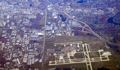
Gerald R. Ford International Airport is a commercial airport in Kent County, Michigan, serving regional and domestic connections. It operates three runways spread across roughly 1,265 hectares and a terminal building with two concourses holding a total of 23 gates for domestic flights.

The airport was originally called Kent County Airport and received its current name in 1999 to honor Gerald R. Ford, who represented Grand Rapids in Congress from 1949 to 1973. The renaming recognizes his political career and later presidency.

The terminal showcases products from Michigan, including coffee from Madcap and beer from Founders Brewing, which travelers can find at several locations. This selection reflects the breweries and roasters that have become well known in the Grand Rapids area.

Several parking options are available, including a short-term garage near the terminal and a more distant economy lot with free shuttle service running around the clock. The shuttle buses run regularly between the lot and the departure levels, so travelers should allow extra time.

The site has used a natural water treatment system since 2013 that channels stormwater through vegetation and soil filters before it reaches surrounding waterways. This approach reduces pollution and sediment, protecting local rivers and streams.

The community of curious travelers

AroundUs brings together thousands of curated places, local tips, and hidden gems, enriched daily by 60,000 contributors worldwide.

Start exploring
Location
Official opening
1963
GPS coordinates
42.88083,-85.52278
Latest update
December 17, 2025 07:34
Around this place
Ada Covered Bridge
United States of America

Ada Covered Bridge

8.5 km
United States of America

Van Noord Arena

7.9 km
United States of America

Whitney Tavern Stand

5.4 km
Thornapple River Drive Bridge
United States of America

Thornapple River Drive Bridge

7 km
United States of America

Forest Hill Park

8.2 km
United States of America

Calvin College Observatory

7.7 km
Kentwood Branch
United States of America

Kentwood Branch

6.1 km
Cascade Township Branch
United States of America

Cascade Township Branch

3.8 km
CSX Thornapple River Bridge
United States of America

CSX Thornapple River Bridge

3.7 km
Cascade Township Hall Historical Marker
United States of America

Cascade Township Hall Historical Marker

4.1 km
Calvin College and Seminary Historical Marker
United States of America

Calvin College and Seminary Historical Marker

7.6 km
Cascade Christian Church Historical Marker
United States of America

Cascade Christian Church Historical Marker

4.1 km
United States of America

Broadmoor Country Club

6.7 km
United States of America

East Paris Nature Preserve Fishing Dock

4.5 km
United States of America

Quail Ridge Golf Club

5.6 km
United States of America

The Cheese

7.8 km
United States of America

Statue, Work of art

8.1 km
United States of America

Scenic viewpoint

7.5 km
United States of America

East Paris Nature Preserve Water Overlook

4.6 km
United States of America

Watermark Country Club

5.6 km
United States of America

Scenic viewpoint

8.6 km
United States of America

Dam Overlook

3.8 km
United States of America

Scenic viewpoint

8.1 km
United States of America

Scenic viewpoint

8.6 km
United States of America

Scenic viewpoint

6 km
United States of America

Scenic viewpoint

5.6 km
United States of America

Scenic viewpoint

5.8 km
United States of America

Scenic viewpoint

9.6 km
Show the full map
Reviews
Share your experience

No review yet

Discussions
Start a discussion...

No discussion yet

« Gerald R. Ford International Airport - Commercial airport in Kent County, Michigan » is provided by Around Us (aroundus.com). Images and texts are derived from Wikimedia project under a Creative Commons license. You are allowed to copy, distribute, and modify copies of this page, under the conditions set by the license, as long as this note is clearly visible.

Discover hidden gems everywhere you go!

From secret cafés to breathtaking viewpoints, skip the crowded tourist spots and find places that match your style. Our app makes it easy with voice search, smart filtering, route optimization, and insider tips from travelers worldwide. Download now for the complete mobile experience.

Around Us App Screenshot

A unique approach to discovering new places

Le Figaro

All the places worth exploring

France Info

A tailor-made excursion in just a few clicks

20 Minutes

Around Us
Travel Guide & Maps
Download

Send to your phone

QR Code
1

Open the camera app on your mobile.

2

Point at the QR code with your camera. A notification will appear.

3

Tap the notification to open the link.