Enable Location

We need your location to show you interesting places around you

Discover nearby places

Find interesting locations and hidden gems around you

Precise directions

Get accurate directions and distances to places

Your location is never shared with other users. It's only used when you tap the location button.

Ripley

Log in to your account

Start exploring — it's free

Trusted by 62,455 travelers worldwide

Continue with Google
Continue with Apple
or

We will send you a code to connect

By continuing, you accept our Terms and Conditions and our Privacy Policy

Check your inbox

We've sent a pincode in your inbox. Please enter the code below.

Ripley, Administrative division in Mississippi, United States

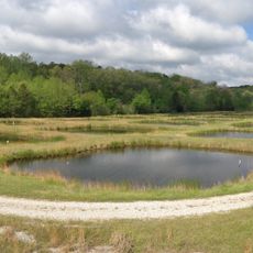
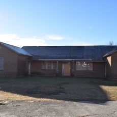
Ripley is an administrative division in Tippah County, Mississippi, that extends across several residential neighborhoods connected by local roads and surrounded by farmland and woodland. The town provides essential services and small businesses that support both permanent residents and visitors passing through the area.

The settlement emerged in the early 19th century following the establishment of transportation routes and developed into a regional administrative center. This growth made it a hub for the surrounding agricultural area.

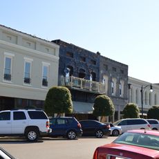
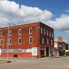
The downtown area serves as a gathering point for neighborhoods, where local shops and community groups shape everyday interaction. This central hub reflects the interconnected character typical of small Mississippi towns.

Visitors can find parking near the downtown area and navigate the residential neighborhoods on foot. Most local services are within easy reach, with clear signage to help orient yourself.

The town developed as an early trading point along historic routes and maintained this role as a passage for travelers. This history still shows in the small shops and services oriented toward people passing through.

The community of curious travelers

AroundUs brings together thousands of curated places, local tips, and hidden gems, enriched daily by 60,000 contributors worldwide.

Start exploring
GPS coordinates
34.73070,-88.94883
Latest update
December 8, 2025 13:41
Around this place
Graceland Too
United States of America

Graceland Too

45.6 km
Wall Doxey State Park
United States of America

Wall Doxey State Park

48.1 km
Walter Place
United States of America

Walter Place

46.4 km
Big Hill Pond State Park
United States of America

Big Hill Pond State Park

40.9 km
Siege and Battle of Corinth Sites
United States of America

Siege and Battle of Corinth Sites

46.4 km
Trace State Park
United States of America

Trace State Park

52.8 km
Boling-Gatewood House
United States of America

Boling-Gatewood House

45.6 km
University of Mississippi Field Station
United States of America

University of Mississippi Field Station

52.3 km
Veranda House
United States of America

Veranda House

45.3 km
Oakleigh
United States of America

Oakleigh

45.3 km
Midtown Corinth Historic District
United States of America

Midtown Corinth Historic District

45.6 km
Ripley Historic District
United States of America

Ripley Historic District

1.6 km
Pocahontas School
United States of America

Pocahontas School

37.7 km
La Grange Historic District
United States of America

La Grange Historic District

42.9 km
Dunvegan
United States of America

Dunvegan

46.1 km
Old Water and Electric Light Plant
United States of America

Old Water and Electric Light Plant

45.8 km
George Wright Young House
United States of America

George Wright Young House

55.7 km
Southwest Holly Springs Historic District
United States of America

Southwest Holly Springs Historic District

46.1 km
Immanuel Church
United States of America

Immanuel Church

44 km
Downtown Corinth Historic District
United States of America

Downtown Corinth Historic District

45.3 km
Downtown Booneville Historic District
United States of America

Downtown Booneville Historic District

36.3 km
Dr. Isham G. Bailey House
United States of America

Dr. Isham G. Bailey House

48.4 km
Civil War Earthworks at Tallahatchie Crossing
United States of America

Civil War Earthworks at Tallahatchie Crossing

53 km
Old U.S. Post Office
United States of America

Old U.S. Post Office

121 m
Shiloh Chennault Bed and Breakfast - Plantation - West Tennessee - Boutique Hotel
United States of America

Shiloh Chennault Bed and Breakfast - Plantation - West Tennessee - Boutique Hotel

52.3 km
National Bird Dog Museum
United States of America

National Bird Dog Museum

42 km
East Holly Springs Historic District
United States of America

East Holly Springs Historic District

45.2 km
Wall Doxey State Park Historic District
United States of America

Wall Doxey State Park Historic District

47.5 km
Show the full map
« Ripley - Administrative division in Mississippi, United States » is provided by Around Us (aroundus.com). Images and texts are derived from Wikimedia project under a Creative Commons license. You are allowed to copy, distribute, and modify copies of this page, under the conditions set by the license, as long as this note is clearly visible.

Discover hidden gems everywhere you go!

From secret cafés to breathtaking viewpoints, skip the crowded tourist spots and find places that match your style. Our app makes it easy with voice search, smart filtering, route optimization, and insider tips from travelers worldwide. Download now for the complete mobile experience.

Around Us App Screenshot

A unique approach to discovering new places

Le Figaro

All the places worth exploring

France Info

A tailor-made excursion in just a few clicks

20 Minutes

Around Us
Travel Guide & Maps
Download

Send to your phone

QR Code
1

Open the camera app on your mobile.

2

Point at the QR code with your camera. A notification will appear.

3

Tap the notification to open the link.