Enable Location

We need your location to show you interesting places around you

Discover nearby places

Find interesting locations and hidden gems around you

Precise directions

Get accurate directions and distances to places

Your location is never shared with other users. It's only used when you tap the location button.

Sneedville

Log in to your account

Start exploring — it's free

Trusted by 68,053 travelers worldwide

Continue with Google
Continue with Apple
or

We will send you a code to connect

By continuing, you accept our Terms and Conditions and our Privacy Policy

Check your inbox

We've sent a pincode in your inbox. Please enter the code below.

Discussion Reviews 1 Photos
59k Popularity

Sneedville, County seat in Hancock County, Tennessee, United States

Sneedville is a small town in eastern Tennessee serving as the county seat of Hancock County, positioned between two river valleys in the southern Appalachian Mountains. The town covers roughly 6 square kilometers (2.3 square miles) at an elevation of around 360 meters (1,170 feet) and functions as the administrative and commercial center for this rural region.

The first settlers arrived in the 1790s from Virginia and North Carolina after the Revolutionary War ended. The town developed slowly as a local trading center for families farming in the surrounding mountains.

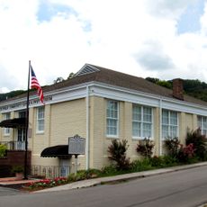
The Hancock County Historical Society maintains a museum in the Old County Jail that displays artifacts of traditional mountain life.

The county extension office on Campbell Drive at number 122 issues building permits and offers services for residents. The town is accessible via smaller rural roads and serves as a base for exploring the mountainous surroundings.

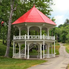
Several barns along the roads display hand-painted squares with traditional quilt patterns, linking eight locations from Willis to Xenophon. The old county jail now houses a museum run by the Hancock County Historical Society with objects from mountain life.

The community of curious travelers

AroundUs brings together thousands of curated places, local tips, and hidden gems, enriched daily by 60,000 contributors worldwide.

Start exploring
Location
Elevation above the sea
357 m
GPS coordinates
36.53194,-83.21417
Latest update
December 17, 2025 07:35
Around this place
United States of America

Pressmen's Home

17 km
Vardy Community School
United States of America

Vardy Community School

6.2 km
Tate Springs Springhouse
United States of America

Tate Springs Springhouse

24.6 km
The Cedars Natural Area Preserve
United States of America

The Cedars Natural Area Preserve

15.6 km
United States of America

Unthanks Cave Natural Area Preserve

9.2 km
Rogersville Historic District
United States of America

Rogersville Historic District

23.3 km
United States of America

Cranks Creek Lake

23.5 km
Hawkins County Courthouse
United States of America

Hawkins County Courthouse

23.3 km
Price Public Elementary School
United States of America

Price Public Elementary School

22.9 km
St. Marks Presbyterian Church
United States of America

St. Marks Presbyterian Church

22.9 km
Jonesville Methodist Campground
United States of America

Jonesville Methodist Campground

17.9 km
Dickinson-Milbourn House
United States of America

Dickinson-Milbourn House

19 km
Hale Springs Inn
United States of America

Hale Springs Inn

23.2 km
United States of America

Cox Shoals

24 km
United States of America

Bulls Shoals

20.1 km
United States of America

Fletcher Cliff

10.2 km
United States of America

White Cliff

24.8 km
United States of America

Herb Smith Lake

23.6 km
United States of America

The Rounds

21.4 km
United States of America

Vardy School Community Historic District

5.9 km
United States of America

Taylor Bluff

20.9 km
United States of America

Slanting Misery

14.4 km
Martins Fork Lake
United States of America

Martins Fork Lake

24.2 km
United States of America

Cedar Hill Country Club

13.9 km
United States of America

Clinchview Golf and Country Club

22.3 km
United States of America

CDC Totem Pole

22.9 km
United States of America

Ewing Trail

24 km
United States of America

Ewing Trail (Horseback)

23.9 km
Show the full map
Reviews
Share your experience

No review yet

Discussions
Start a discussion...

No discussion yet

« Sneedville - County seat in Hancock County, Tennessee, United States » is provided by Around Us (aroundus.com). Images and texts are derived from Wikimedia project under a Creative Commons license. You are allowed to copy, distribute, and modify copies of this page, under the conditions set by the license, as long as this note is clearly visible.

Discover hidden gems everywhere you go!

From secret cafés to breathtaking viewpoints, skip the crowded tourist spots and find places that match your style. Our app makes it easy with voice search, smart filtering, route optimization, and insider tips from travelers worldwide. Download now for the complete mobile experience.

Around Us App Screenshot

A unique approach to discovering new places

Le Figaro

All the places worth exploring

France Info

A tailor-made excursion in just a few clicks

20 Minutes

Around Us
Travel Guide & Maps
Download

Send to your phone

QR Code
1

Open the camera app on your mobile.

2

Point at the QR code with your camera. A notification will appear.

3

Tap the notification to open the link.