Chest opened
+${chestReward.xp} XP
Explorer
NOUVEAU ×${chestReward.collectible.quantity}
tapez pour fermer
Chest locked

Open chests in the app

Around Us is built for your phone — chests unlock when you walk, explore and capture nearby places.

Enable Location

We need your location to show you interesting places around you

Discover nearby places

Find interesting locations and hidden gems around you

Precise directions

Get accurate directions and distances to places

Your location is never shared with other users. It's only used when you tap the location button.

Maryland Route 200

Log in to your account

Start exploring — it's free

Trusted by 72,992 travelers worldwide

Continue with Google
Continue with Apple
or

We will send you a code to connect

By continuing, you accept our Terms and Conditions and our Privacy Policy

Check your inbox

We've sent a pincode in your inbox. Please enter the code below.

Maryland Route 200
Discussion Reviews 1 Photos
21.5k Popularity

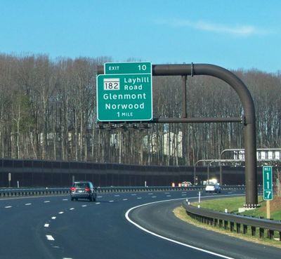
Maryland Route 200, toll highway in Maryland, United States

Maryland Route 200 is a toll road spanning Montgomery County and Prince George's County. It connects major transportation corridors and passes through areas of mixed development, from commercial zones to residential neighborhoods.

The road was developed to improve and manage traffic flow in the Washington-Baltimore region. It arose from planning efforts to optimize transportation connections in this rapidly expanding area.

As a toll road, usage requires payment of fees. Travelers should prepare for longer travel times during peak hours and ensure they have a working E-Pass system or payment method available.

The community of curious travelers

AroundUs brings together thousands of curated places, local tips, and hidden gems, enriched daily by 60,000 contributors worldwide.

Start exploring
Inception
November 22, 2011
Part of
National Highway System
GPS coordinates
39.13150,-77.17006
Latest update
December 14, 2025 17:01
Around this place
Seneca Creek State Park
United States of America

Seneca Creek State Park

7.6 km
Lake Needwood
United States of America

Lake Needwood

3.7 km
Wilkins Estate
United States of America

Wilkins Estate

9 km
Third Addition to Rockville and Old St. Mary's Church and Cemetery
United States of America

Third Addition to Rockville and Old St. Mary's Church and Cemetery

5.9 km
Glenview Farm
United States of America

Glenview Farm

6.1 km
Beall-Dawson House
United States of America

Beall-Dawson House

5.4 km
Gaithersburg Latitude Observatory
United States of America

Gaithersburg Latitude Observatory

2.6 km
Beth Sholom Congregation and Talmud Torah
United States of America

Beth Sholom Congregation and Talmud Torah

9 km
Lakelands Park
United States of America

Lakelands Park

5.9 km
Falls Road Park
United States of America

Falls Road Park

7.6 km
B'nai Israel Congregation
United States of America

B'nai Israel Congregation

9.3 km
Latvian Museum
United States of America

Latvian Museum

5.1 km
West Montgomery Avenue Historic District
United States of America

West Montgomery Avenue Historic District

5.4 km
The Ridge
United States of America

The Ridge

6 km
Bingham-Brewer House
United States of America

Bingham-Brewer House

5.6 km
Frieda Fromm-Reichmann Cottage
United States of America

Frieda Fromm-Reichmann Cottage

5.4 km
Rockville Park Historic District
United States of America

Rockville Park Historic District

6.1 km
Layton House
United States of America

Layton House

9.2 km
Gaithersburg Water Park
United States of America

Gaithersburg Water Park

2.2 km
Oaks II
United States of America

Oaks II

8.4 km
Lake Bernard Frank
United States of America

Lake Bernard Frank

5.6 km
Montgomery County Circuit Courthouses
United States of America

Montgomery County Circuit Courthouses

5.6 km
Serpentine Barrens Conservation Park
United States of America

Serpentine Barrens Conservation Park

8.8 km
Rock Creek Regional Park
United States of America

Rock Creek Regional Park

3.2 km
David Scull Park
United States of America

David Scull Park

5.2 km
Hillcrest Park
United States of America

Hillcrest Park

6.8 km
Olney Library
United States of America

Olney Library

9.1 km
Rockville Memorial Library
United States of America

Rockville Memorial Library

5.2 km
Show the full map
Reviews
Share your experience

No review yet

Discussions
Start a discussion...

No discussion yet

« Maryland Route 200 - toll highway in Maryland, United States » is provided by Around Us (aroundus.com). Images and texts are derived from Wikimedia project under a Creative Commons license. You are allowed to copy, distribute, and modify copies of this page, under the conditions set by the license, as long as this note is clearly visible.

Discover hidden gems everywhere you go!

From secret cafés to breathtaking viewpoints, skip the crowded tourist spots and find places that match your style. Our app makes it easy with voice search, smart filtering, route optimization, and insider tips from travelers worldwide. Download now for the complete mobile experience.

Around Us App Screenshot

A unique approach to discovering new places

Le Figaro

All the places worth exploring

France Info

A tailor-made excursion in just a few clicks

20 Minutes

Around Us
Travel Guide & Maps
Download

Send to your phone

QR Code
1

Open the camera app on your mobile.

2

Point at the QR code with your camera. A notification will appear.

3

Tap the notification to open the link.