Enable Location

We need your location to show you interesting places around you

Discover nearby places

Find interesting locations and hidden gems around you

Precise directions

Get accurate directions and distances to places

Your location is never shared with other users. It's only used when you tap the location button.

Log in to your account

Start exploring — it's free

Trusted by 61,464 travelers worldwide

Continue with Google
Continue with Apple
or

We will send you a code to connect

By continuing, you accept our Terms and Conditions and our Privacy Policy

Check your inbox

We've sent a pincode in your inbox. Please enter the code below.

Indian Mound Reserve

Indian Mound Reserve, Country park near Cedarville, United States.

Description

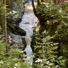
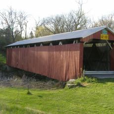
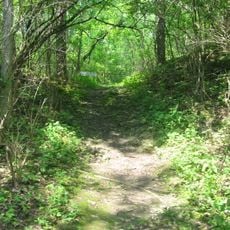
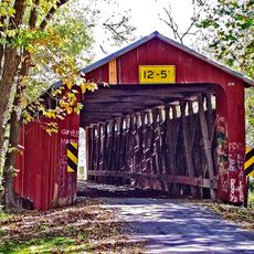
Indian Mound Reserve is a protected area covering 169 acres with diverse landscapes that connect Cedar Cliff Falls, Peterson Park, and Williamson Mound. Hiking trails link these different sections and allow visitors to move between the various features throughout the reserve.

History

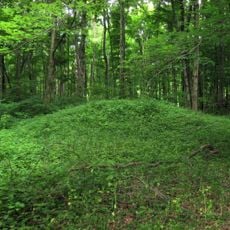
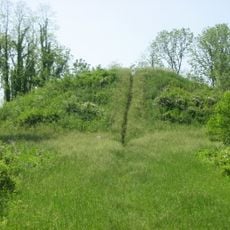
Williamson Mound and the Pollock Works are ancient earthworks built by early Native Americans and were added to the National Register of Historic Places in the 1970s. These structures represent a period when people deliberately shaped the land for protection and community purposes.

Culture

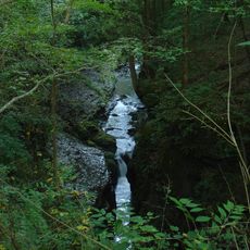
The Pollock Works sit on a high overlook above Massies Creek with limestone walls and curved earthworks that once protected early communities. Visitors today can walk among these structures and see how the land was shaped to serve defensive needs.

Practical

The reserve offers eight miles of hiking trails, multiple picnic areas, and a designated viewpoint for Cedar Cliff Falls. Visitors should wear sturdy shoes and allow time to explore the different sections at a comfortable pace.

Did you know?

A restored log cabin predating 1825 sits within the reserve and shows how people lived during that era. Educational programs use this building to help visitors understand the connection between early settlers and the archaeological sites nearby.

GPS coordinates
39.73970,-83.82330
Latest update
December 11, 2025 18:09

AroundUs brings together thousands of curated places, local tips, and hidden gems, enriched daily by 60,000 contributors worldwide. Discover all places nearby (Cedarville Township).

Around this place
Little Miami Scenic Trail
United States of America

Little Miami Scenic Trail

9.3 km
John Bryan State Park
United States of America

John Bryan State Park

6.1 km
Glen Helen Nature Preserve
United States of America

Glen Helen Nature Preserve

8.3 km
Charles Young Buffalo Soldiers National Monument
United States of America

Charles Young Buffalo Soldiers National Monument

7.1 km
Whitelaw Reid House
United States of America

Whitelaw Reid House

1.7 km
United States of America

National Afro-American Museum and Cultural Center

5.5 km
Clifton Gorge State Nature Preserve
United States of America

Clifton Gorge State Nature Preserve

5.9 km
Orators Mound
United States of America

Orators Mound

8.8 km
Greene County Courthouse
United States of America

Greene County Courthouse

10.9 km
Hollencamp House
United States of America

Hollencamp House

10.6 km
Yellow Springs Historic District
United States of America

Yellow Springs Historic District

9 km
East Second Street Historic District
United States of America

East Second Street Historic District

10.7 km
Cedarville Opera House
United States of America

Cedarville Opera House

1.4 km
Ballard Road Covered Bridge
United States of America

Ballard Road Covered Bridge

6.9 km
Antioch Hall, North and South Halls
United States of America

Antioch Hall, North and South Halls

8.7 km
Harper Mausoleum and George W. Harper Memorial Entrance
United States of America

Harper Mausoleum and George W. Harper Memorial Entrance

1.9 km
Samuel N. Patterson House
United States of America

Samuel N. Patterson House

10.9 km
Millen-Schmidt House
United States of America

Millen-Schmidt House

11 km
Alexander Conner House
United States of America

Alexander Conner House

10.9 km
National Afro-American Museum and Cultural Center
United States of America

National Afro-American Museum and Cultural Center

5.6 km
Yellow Springs Branch Library
United States of America

Yellow Springs Branch Library

9.1 km
Wilberforce Carnegie Library
United States of America

Wilberforce Carnegie Library

5.6 km
Stevenson Road Covered Bridge
United States of America

Stevenson Road Covered Bridge

6.4 km
Williamson Mound State Memorial
United States of America

Williamson Mound State Memorial

667 m
Pollock Work
United States of America

Pollock Work

4 m
Charleton Mill Covered Bridge
United States of America

Charleton Mill Covered Bridge

4.2 km
Glen Helen Bridge
United States of America

Glen Helen Bridge

6.9 km
Galloway Log House
United States of America

Galloway Log House

10.9 km
Show the full map
« Indian Mound Reserve - Country park near Cedarville, United States » is provided by Around Us (aroundus.com). Images and texts are derived from Wikimedia project under a Creative Commons license. You are allowed to copy, distribute, and modify copies of this page, under the conditions set by the license, as long as this note is clearly visible.

Discover hidden gems everywhere you go!

From secret cafés to breathtaking viewpoints, skip the crowded tourist spots and find places that match your style. Our app makes it easy with voice search, smart filtering, route optimization, and insider tips from travelers worldwide. Download now for the complete mobile experience.

Around Us App Screenshot

A unique approach to discovering new places

Le Figaro

All the places worth exploring

France Info

A tailor-made excursion in just a few clicks

20 Minutes

Around Us
Travel Guide & Maps
Download

Send to your phone

QR Code
1

Open the camera app on your mobile.

2

Point at the QR code with your camera. A notification will appear.

3

Tap the notification to open the link.