Enable Location

We need your location to show you interesting places around you

Discover nearby places

Find interesting locations and hidden gems around you

Precise directions

Get accurate directions and distances to places

Your location is never shared with other users. It's only used when you tap the location button.

Ponquogue Bridge

Log in to your account

Start exploring — it's free

Trusted by 63,025 travelers worldwide

Continue with Google
Continue with Apple
or

We will send you a code to connect

By continuing, you accept our Terms and Conditions and our Privacy Policy

Check your inbox

We've sent a pincode in your inbox. Please enter the code below.

Ponquogue Bridge
Discussion Reviews 1 Photos
2.9k Popularity

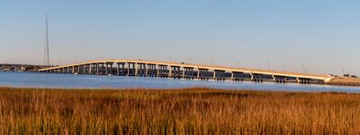
Ponquogue Bridge, Transportation bridge in Hampton Bays, New York, US.

Ponquogue Bridge is a concrete bridge spanning Shinnecock Bay and connecting Hampton Bays to the eastern portion of Westhampton Island. The structure accommodates two traffic lanes as well as designated paths for pedestrians and cyclists.

This concrete structure was built in 1986 as a replacement for a wooden drawbridge dating from 1930. The original span now functions as a public fishing pier and stands as a remnant of the earlier crossing.

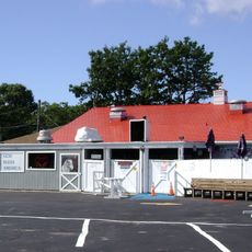
The bridge structure has transformed into a central point for community gatherings, with the marine park hosting regular fishing and recreational activities.

The bridge maintains a vertical clearance of about 55 feet above the water and allows passage for various types of watercraft below. Visitors should expect moderate to heavy traffic, particularly on weekends and during peak seasons.

The remains of the old bridge were transformed into a marine park where visitors can access boat launches, diving spots, and fishing platforms. This creative reuse gave the historic structure a second life while continuing to serve the community.

The community of curious travelers

AroundUs brings together thousands of curated places, local tips, and hidden gems, enriched daily by 60,000 contributors worldwide.

Start exploring
Location
GPS coordinates
40.84390,-72.50110
Latest update
December 12, 2025 12:06
Around this place
Shinnecock Hills Golf Club
United States of America

Shinnecock Hills Golf Club

7.8 km
National Golf Links of America
United States of America

National Golf Links of America

8.4 km
Parrish Art Museum
United States of America

Parrish Art Museum

13.2 km
Basilica of the Sacred Hearts of Jesus and Mary
United States of America

Basilica of the Sacred Hearts of Jesus and Mary

9.7 km
United States of America

Halsey House

10.2 km
Boardy Barn
United States of America

Boardy Barn

4.8 km
Conscience Point National Wildlife Refuge
United States of America

Conscience Point National Wildlife Refuge

12.8 km
James L. Breese House
United States of America

James L. Breese House

9.7 km
Quogue Historic District
United States of America

Quogue Historic District

9.3 km
Shinnecock Light
United States of America

Shinnecock Light

790 m
Rosemary Lodge
United States of America

Rosemary Lodge

12.2 km
United States of America

Red Maples

8.8 km
Big Duck Ranch
United States of America

Big Duck Ranch

12.5 km
Jedediah Hawkins House
United States of America

Jedediah Hawkins House

13.3 km
Southampton Village Historic District
United States of America

Southampton Village Historic District

9.8 km
William Merritt Chase Homestead
United States of America

William Merritt Chase Homestead

5.4 km
North Main Street Historic District
United States of America

North Main Street Historic District

10.9 km
Beach Road Historic District
United States of America

Beach Road Historic District

7.3 km
Wickapogue Road Historic District
United States of America

Wickapogue Road Historic District

12.1 km
Balcastle
United States of America

Balcastle

10.8 km
Jamesport Meeting House
United States of America

Jamesport Meeting House

13.6 km
Crowther House
United States of America

Crowther House

12 km
James Benjamin Homestead
United States of America

James Benjamin Homestead

11.8 km
Foster-Meeker House
United States of America

Foster-Meeker House

12.5 km
Capt. C. Goodale House
United States of America

Capt. C. Goodale House

11.4 km
Paul Cuffee grave
United States of America

Paul Cuffee grave

4.3 km
Southampton History Museum
United States of America

Southampton History Museum

10.5 km
Black Point
United States of America

Black Point

11.7 km
Show the full map
Reviews
Share your experience

No review yet

Discussions
Start a discussion...

No discussion yet

« Ponquogue Bridge - Transportation bridge in Hampton Bays, New York, US » is provided by Around Us (aroundus.com). Images and texts are derived from Wikimedia project under a Creative Commons license. You are allowed to copy, distribute, and modify copies of this page, under the conditions set by the license, as long as this note is clearly visible.

Discover hidden gems everywhere you go!

From secret cafés to breathtaking viewpoints, skip the crowded tourist spots and find places that match your style. Our app makes it easy with voice search, smart filtering, route optimization, and insider tips from travelers worldwide. Download now for the complete mobile experience.

Around Us App Screenshot

A unique approach to discovering new places

Le Figaro

All the places worth exploring

France Info

A tailor-made excursion in just a few clicks

20 Minutes

Around Us
Travel Guide & Maps
Download

Send to your phone

QR Code
1

Open the camera app on your mobile.

2

Point at the QR code with your camera. A notification will appear.

3

Tap the notification to open the link.