Enable Location

We need your location to show you interesting places around you

Discover nearby places

Find interesting locations and hidden gems around you

Precise directions

Get accurate directions and distances to places

Your location is never shared with other users. It's only used when you tap the location button.

Kansas State Capitol

Log in to your account

Start exploring — it's free

Trusted by 61,508 travelers worldwide

Continue with Google
Continue with Apple
or

We will send you a code to connect

By continuing, you accept our Terms and Conditions and our Privacy Policy

Check your inbox

We've sent a pincode in your inbox. Please enter the code below.

Kansas State Capitol, State capitol building in Topeka, United States

Description

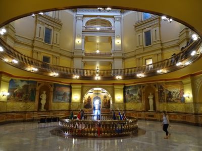
The Kansas State Capitol is a government building in French Renaissance style located in Topeka, built from pale limestone quarried nearby. The copper dome rises above the city and can be seen from many points around town.

History

Construction began in 1866 after the Civil War ended and continued over several decades. The building was completed in 1903 after the east and west wings and the main structure were added in stages.

Culture

John Steuart Curry painted large scenes in the 1930s showing moments from the frontier period and tensions before the Civil War. His works hang in the upper levels and draw visitors who want to see how this chapter was portrayed.

Practical

Tours take place on weekdays and show the different levels of the building, while the climb to the dome observation platform involves stairs. Visitors planning to reach the platform should be prepared for the many steps.

Did you know?

The height of the dome surpasses that of the Capitol in Washington, though its diameter is smaller. These proportions give the structure a slender silhouette on the Topeka skyline.

Location
Inception
1866
Architects
E. Townsend Mix, John G. Haskell
Architectural style
French Renaissance architecture
Floors above the ground
4
Made from material
stone
Address
300 SW 10th Avenue
GPS coordinates
39.04801,-95.67816
Latest update
December 5, 2025 22:28

AroundUs brings together thousands of curated places, local tips, and hidden gems, enriched daily by 60,000 contributors worldwide. Discover all places nearby (Topeka).

Around this place
Equality House
United States of America

Equality House

3.7 km
Topeka High School
United States of America

Topeka High School

653 m
Cedar Crest
United States of America

Cedar Crest

6.3 km
Gage Park
United States of America

Gage Park

4.6 km
Topeka Zoo
United States of America

Topeka Zoo

4.2 km
Brown v. Board of Education National Historical Park
United States of America

Brown v. Board of Education National Historical Park

1.1 km
Topeka & Shawnee County Public Library
United States of America

Topeka & Shawnee County Public Library

1.6 km
Great Overland Station
United States of America

Great Overland Station

2.2 km
Reinisch Rose Garden and Doran Rock Garden
United States of America

Reinisch Rose Garden and Doran Rock Garden

4.6 km
Yager Stadium
United States of America

Yager Stadium

2.5 km
Constitution Hall
United States of America

Constitution Hall

856 m
Truckhenge
United States of America

Truckhenge

7.4 km
United States of America

Kanza Bowl

3.3 km
St. Joseph's Catholic Church
United States of America

St. Joseph's Catholic Church

1 km
Ward-Meade House
United States of America

Ward-Meade House

1.8 km
Church of the Assumption and Rectory
United States of America

Church of the Assumption and Rectory

406 m
Memorial Building
United States of America

Memorial Building

252 m
Evel Knievel Museum
United States of America

Evel Knievel Museum

2 km
Topeka Council of Colored Women's Clubs Building
United States of America

Topeka Council of Colored Women's Clubs Building

1.4 km
Pottawatomie Baptist Mission Building
United States of America

Pottawatomie Baptist Mission Building

8.4 km
Discovery Center of Kansas
United States of America

Discovery Center of Kansas

4.8 km
St. John's Lutheran School
United States of America

St. John's Lutheran School

840 m
St. John African Methodist Episcopal Church
United States of America

St. John African Methodist Episcopal Church

429 m
Westminster Presbyterian Church of Topeka
United States of America

Westminster Presbyterian Church of Topeka

2.1 km
Chester B. Woodward House
United States of America

Chester B. Woodward House

1 km
North Topeka Baptist Church
United States of America

North Topeka Baptist Church

2.5 km
South Kansas Avenue Commercial Historic District
United States of America

South Kansas Avenue Commercial Historic District

313 m
Crawford Building
United States of America

Crawford Building

698 m
Show the full map
« Kansas State Capitol - State capitol building in Topeka, United States » is provided by Around Us (aroundus.com). Images and texts are derived from Wikimedia project under a Creative Commons license. You are allowed to copy, distribute, and modify copies of this page, under the conditions set by the license, as long as this note is clearly visible.

Discover hidden gems everywhere you go!

From secret cafés to breathtaking viewpoints, skip the crowded tourist spots and find places that match your style. Our app makes it easy with voice search, smart filtering, route optimization, and insider tips from travelers worldwide. Download now for the complete mobile experience.

Around Us App Screenshot

A unique approach to discovering new places

Le Figaro

All the places worth exploring

France Info

A tailor-made excursion in just a few clicks

20 Minutes

Around Us
Travel Guide & Maps
Download

Send to your phone

QR Code
1

Open the camera app on your mobile.

2

Point at the QR code with your camera. A notification will appear.

3

Tap the notification to open the link.