Enable Location

We need your location to show you interesting places around you

Discover nearby places

Find interesting locations and hidden gems around you

Precise directions

Get accurate directions and distances to places

Your location is never shared with other users. It's only used when you tap the location button.

Henning

Log in to your account

Start exploring — it's free

Trusted by 61,980 travelers worldwide

Continue with Google
Continue with Apple
or

We will send you a code to connect

By continuing, you accept our Terms and Conditions and our Privacy Policy

Check your inbox

We've sent a pincode in your inbox. Please enter the code below.

Henning, Administrative division in Lauderdale County, Tennessee, United States.

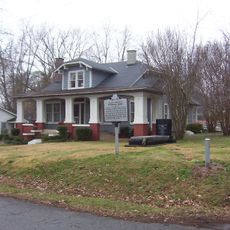
Henning is a small town in Lauderdale County in western Tennessee with a total area of about 2.47 square miles. The community includes a Town Hall where residents access municipal services and utilities like water and sewer systems.

The town began in the late 1800s and took its name from William H. Henning, a railway official involved in early business growth. The railroad connection helped establish the settlement in this part of Tennessee.

The town is home to a diverse population that shapes daily community life and local events. This mix of backgrounds creates the character visible in how residents interact and gather together.

The best way to explore is by car or on foot, since it is a compact community with neighborhood streets. Town services and basic facilities are located centrally and accessible during standard business hours.

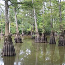
The Mississippi Band of Choctaw Indians holds 79 acres of federal trust land here, making it Tennessee's only tribal territory. This distinctive presence connects the town to Native American heritage in an uncommon way for the state.

The community of curious travelers

AroundUs brings together thousands of curated places, local tips, and hidden gems, enriched daily by 60,000 contributors worldwide.

Start exploring
Inception
1873
Elevation above the sea
89 m
GPS coordinates
35.67361,-89.57750
Latest update
December 7, 2025 10:07
Around this place
West Tennessee
United States of America

West Tennessee

34.3 km
Fort Pillow State Park
United States of America

Fort Pillow State Park

24.3 km
Nodena Site
United States of America

Nodena Site

36.4 km
Alex Haley House and Museum
United States of America

Alex Haley House and Museum

105 m
Hatchie National Wildlife Refuge
United States of America

Hatchie National Wildlife Refuge

38 km
Temple Adas Israel
United States of America

Temple Adas Israel

29.8 km
Mississippi County Courthouse
United States of America

Mississippi County Courthouse

35.6 km
Edward Moody King House
United States of America

Edward Moody King House

43.5 km
Mississippi County Courthouse
United States of America

Mississippi County Courthouse

40.9 km
Zion Church
United States of America

Zion Church

29.9 km
Kress Building
United States of America

Kress Building

40.2 km
Hotel Lindo
United States of America

Hotel Lindo

13.6 km
Bank of Osceola
United States of America

Bank of Osceola

35.3 km
City Hall
United States of America

City Hall

35.7 km
Lauderdale County Courthouse
United States of America

Lauderdale County Courthouse

9.1 km
Osceola Times Building
United States of America

Osceola Times Building

35.5 km
United States of America

Lucerne

42.2 km
Hale Avenue Historic District
United States of America

Hale Avenue Historic District

35.6 km
Joshua K. Hutchison House
United States of America

Joshua K. Hutchison House

30.1 km
West Main Street Residential Historic District
United States of America

West Main Street Residential Historic District

41.5 km
Wilson Residential Historic District
United States of America

Wilson Residential Historic District

42.4 km
Florida Brothers Building
United States of America

Florida Brothers Building

35.7 km
United States of America

Stanton Masonic Lodge and School

27.9 km
Chris Tompkins House
United States of America

Chris Tompkins House

36.3 km
Brownsville Carnegie Library
United States of America

Brownsville Carnegie Library

29.8 km
Fort Pillow State Historic Park
United States of America

Fort Pillow State Historic Park

25.2 km
Stanton School
United States of America

Stanton School

28.2 km
Trinity United Methodist Church
United States of America

Trinity United Methodist Church

15.4 km
Show the full map
« Henning - Administrative division in Lauderdale County, Tennessee, United States » is provided by Around Us (aroundus.com). Images and texts are derived from Wikimedia project under a Creative Commons license. You are allowed to copy, distribute, and modify copies of this page, under the conditions set by the license, as long as this note is clearly visible.

Discover hidden gems everywhere you go!

From secret cafés to breathtaking viewpoints, skip the crowded tourist spots and find places that match your style. Our app makes it easy with voice search, smart filtering, route optimization, and insider tips from travelers worldwide. Download now for the complete mobile experience.

Around Us App Screenshot

A unique approach to discovering new places

Le Figaro

All the places worth exploring

France Info

A tailor-made excursion in just a few clicks

20 Minutes

Around Us
Travel Guide & Maps
Download

Send to your phone

QR Code
1

Open the camera app on your mobile.

2

Point at the QR code with your camera. A notification will appear.

3

Tap the notification to open the link.