Corning

Log in to your account

AroundUs is a community-driven map of interesting places, built by curious explorers like you. It grows with every review, story, and photo you share.
Connect to save your favorite spots, contribute locations, and create personalized routes.
Continue with Google
Continue with Apple
Continue with X
Continue with Facebook
Continue with email
By continuing, you accept our Terms and Conditions and our Privacy Policy
Create an account
Add to collection
Map
Suggest a change
Share

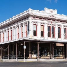
Corning, Agricultural city in Tehama County, California, United States

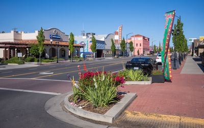
Corning is a city in Tehama County in northern California, positioned roughly 100 miles north of Sacramento along Interstate 5 and Highway 99. The area centers on agriculture, particularly olive growing and processing, which shapes the local economy and landscape.

The city began in 1882 when the railroad arrived and received its name from railroad official John Corning, then incorporated as a city in 1907. This rail connection enabled the transport of agricultural products and shaped its growth as a farming center.

The annual Corning Olive Festival celebrates the agricultural tradition rooted in olive farming, drawing locals and visitors to honor the region's farming identity. This tradition shapes how people here see themselves and their connection to the land.

The city sits directly on Interstate 5 and Highway 99, making it easy to arrive and navigate the area. Visit during daytime hours to see the agricultural operations and local processing activities in their daily working rhythm.

Sevillano olives thrive in the local climate and soil conditions because this variety resists harsh winters and pests that would kill other fruit trees. This natural advantage turned the area into a center for olive farming when other crops could not survive the conditions.

Location: Tehama County

Inception: August 6, 1907

Elevation above the sea: 84 m

Website: https://corning.org

GPS coordinates: 39.92611,-122.18056

Latest update: December 16, 2025 13:38

Photos
Around this place
Bidwell Mansion State Historic Park
United States of America

Bidwell Mansion State Historic Park

35 km
Abbey of New Clairvaux
United States of America

Abbey of New Clairvaux

10.2 km
Black Butte Lake
United States of America

Black Butte Lake

20.2 km
Sacramento River National Wildlife Refuge
United States of America

Sacramento River National Wildlife Refuge

31.2 km
United States of America

Bidwell-Sacramento River State Park

24.9 km
Chico Air Museum
United States of America

Chico Air Museum

30.7 km
Gianella Bridge
United States of America

Gianella Bridge

25.1 km
State Theatre
United States of America

State Theatre

28.2 km
Odd Fellows Building
United States of America

Odd Fellows Building

28.3 km
Old Bank of America Building
United States of America

Old Bank of America Building

28.4 km
United States of America

Military Museum of Butte County

24.4 km
Saint Mary's Parish
United States of America

Saint Mary's Parish

28.1 km
Maywood Woman's Club
United States of America

Maywood Woman's Club

399 m
United States of America

Captain Jones Rapids

8.4 km
United States of America

Steamboat Point

31.8 km
UP Sacramento River Bridge
United States of America

UP Sacramento River Bridge

12.6 km
United States of America

Oak Creek Golf Course (Red Bluff)

24.8 km
United States of America

Woodson Bridge State Recreation Area

7.7 km
United States of America

Wilcox Oaks Golf Course

33.3 km
United States of America

Chico Air Museum

30.7 km
United States of America

Irving Finch River Access

25.1 km
United States of America

Aircraft model, monument featuring aircraft

30.8 km
United States of America

Monument featuring aircraft, aircraft model

30.8 km
United States of America

Monument featuring aircraft, aircraft model

30.8 km
United States of America

Monument featuring aircraft, aircraft model

30.8 km
United States of America

Monument featuring aircraft, aircraft model

30.8 km
United States of America

Aircraft model, monument featuring aircraft

30.8 km
United States of America

Monument featuring aircraft, aircraft model

30.8 km
Show the full map
Reviews

Visited this place? Tap the stars to rate it and share your experience / photos with the community! Try now! You can cancel it anytime.

« Corning - Agricultural city in Tehama County, California, United States » is provided by Around Us (aroundus.com). Images and texts are derived from Wikimedia project under a Creative Commons license. You are allowed to copy, distribute, and modify copies of this page, under the conditions set by the license, as long as this note is clearly visible.

Discover hidden gems everywhere you go!

From secret cafés to breathtaking viewpoints, skip the crowded tourist spots and find places that match your style. Our app makes it easy with voice search, smart filtering, route optimization, and insider tips from travelers worldwide. Download now for the complete mobile experience.

Around Us App Screenshot

A unique approach to discovering new places

Le Figaro

All the places worth exploring

France Info

A tailor-made excursion in just a few clicks

20 Minutes