Enable Location

We need your location to show you interesting places around you

Discover nearby places

Find interesting locations and hidden gems around you

Precise directions

Get accurate directions and distances to places

Your location is never shared with other users. It's only used when you tap the location button.

Black Butte Lake

Log in to your account

Start exploring — it's free

Trusted by 64,497 travelers worldwide

Continue with Google
Continue with Apple
or

We will send you a code to connect

By continuing, you accept our Terms and Conditions and our Privacy Policy

Check your inbox

We've sent a pincode in your inbox. Please enter the code below.

Black Butte Lake
Discussion Reviews 1 Photos
4.6k Popularity

Black Butte Lake, Lake located the United States of America

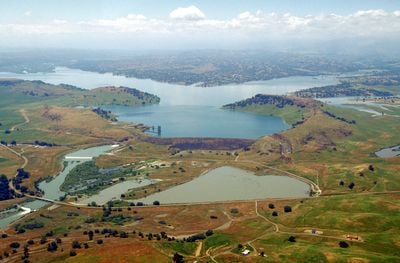
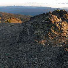
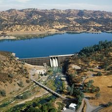
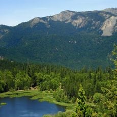
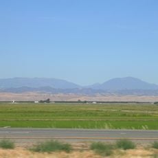
Black Butte Lake is a reservoir in the rolling foothills of northern Central California, managed by the US Army Corps of Engineers. Its shoreline alternates between open grassland and clusters of trees that shade campgrounds and picnic areas along the water's edge.

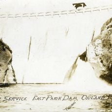
The lake was formed by the construction of Mendocino Dam on Stony Creek in the early 1960s, primarily to control flooding and secure water supplies for the surrounding region. Over time it became a destination for outdoor recreation rather than just a water management structure.

The lake brings together locals and visitors who seek a peaceful escape and outdoor recreation in a shared natural setting. It serves as a gathering place where families and friends spend time fishing, camping, or simply enjoying the day together by the water.

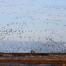
Summer draws the most visitors for boating and swimming, but spring and fall offer milder temperatures that suit hiking and birdwatching more comfortably. Since the nearest towns are a fair drive away, it is worth packing food, gear, and drinking water before arriving.

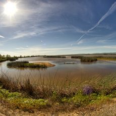
The reservoir sits in one of California's hottest and driest corners, yet in spring the surrounding hills briefly fill with wildflowers that contrast sharply with the dry landscape most visitors associate with this area. This short seasonal change catches many first-time visitors off guard.

The community of curious travelers

AroundUs brings together thousands of curated places, local tips, and hidden gems, enriched daily by 60,000 contributors worldwide.

Start exploring
Location
GPS coordinates
39.80583,-122.35778
Latest update
March 3, 2026 08:12
Around this place
Bidwell Park
United States of America

Bidwell Park

49.7 km
Mendocino National Forest
United States of America

Mendocino National Forest

44.6 km
Bidwell Mansion State Historic Park
United States of America

Bidwell Mansion State Historic Park

44.2 km
Abbey of New Clairvaux
United States of America

Abbey of New Clairvaux

29.1 km
Sacramento National Wildlife Refuge Complex
United States of America

Sacramento National Wildlife Refuge Complex

44.4 km
Mount Linn
United States of America

Mount Linn

49.5 km
Sacramento River National Wildlife Refuge
United States of America

Sacramento River National Wildlife Refuge

36.3 km
Chico Air Museum
United States of America

Chico Air Museum

42.7 km
Stony Gorge Dam
United States of America

Stony Gorge Dam

28.6 km
East Park Dam
United States of America

East Park Dam

51.2 km
Anthony Peak
United States of America

Anthony Peak

52.1 km
Gianella Bridge
United States of America

Gianella Bridge

31.5 km
Chico Community Observatory
United States of America

Chico Community Observatory

49.3 km
State Theatre
United States of America

State Theatre

42.6 km
A. H. Chapman House
United States of America

A. H. Chapman House

46 km
Saint John Mountain
United States of America

Saint John Mountain

50.4 km
Silberstein Park Building
United States of America

Silberstein Park Building

45.2 km
Odd Fellows Building
United States of America

Odd Fellows Building

42.6 km
Old Bank of America Building
United States of America

Old Bank of America Building

42.8 km
Saint Mary's Parish
United States of America

Saint Mary's Parish

42.5 km
Museum of Northern California Art
United States of America

Museum of Northern California Art

44.6 km
Maywood Woman's Club
United States of America

Maywood Woman's Club

20.6 km
Arboreto de la Universidad de California Campus de Chico
United States of America

Arboreto de la Universidad de California Campus de Chico

44.3 km
Senator Theatre
United States of America

Senator Theatre

45.4 km
Rodgers Theatre
United States of America

Rodgers Theatre

20.3 km
Bayliss Carnegie Library
United States of America

Bayliss Carnegie Library

36.4 km
Sacramento National Wildlife Refuge
United States of America

Sacramento National Wildlife Refuge

47.1 km
UP Sacramento River Bridge
United States of America

UP Sacramento River Bridge

32.1 km
Show the full map
Reviews
Share your experience

No review yet

Discussions
Start a discussion...

No discussion yet

« Black Butte Lake - Lake located the United States of America » is provided by Around Us (aroundus.com). Images and texts are derived from Wikimedia project under a Creative Commons license. You are allowed to copy, distribute, and modify copies of this page, under the conditions set by the license, as long as this note is clearly visible.

Discover hidden gems everywhere you go!

From secret cafés to breathtaking viewpoints, skip the crowded tourist spots and find places that match your style. Our app makes it easy with voice search, smart filtering, route optimization, and insider tips from travelers worldwide. Download now for the complete mobile experience.

Around Us App Screenshot

A unique approach to discovering new places

Le Figaro

All the places worth exploring

France Info

A tailor-made excursion in just a few clicks

20 Minutes

Around Us
Travel Guide & Maps
Download

Send to your phone

QR Code
1

Open the camera app on your mobile.

2

Point at the QR code with your camera. A notification will appear.

3

Tap the notification to open the link.