·

Enable Location

We need your location to show you interesting places around you

Discover nearby places

Find interesting locations and hidden gems around you

Precise directions

Get accurate directions and distances to places

Your location is never shared with other users. It's only used when you tap the location button.

Fort de Cavagnal

Log in to your account

Start exploring — it's free

Trusted by 62,645 travelers worldwide

Continue with Google
Continue with Apple
or

We will send you a code to connect

By continuing, you accept our Terms and Conditions and our Privacy Policy

Check your inbox

We've sent a pincode in your inbox. Please enter the code below.

Fort de Cavagnal

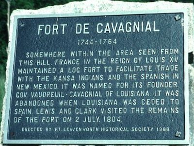
Fort de Cavagnal, French trading fort near Kansas City, United States.

Fort de Cavagnal was a French trading post on the Missouri River about 3 miles northwest of Kansas City. The facility included a stockade with corner bastions and buildings for administration, security, and commercial operations.

French governor Pierre François de Rigaud established the fort in 1744 as a strategic trading position with the Kansa and Osage. The post was eventually abandoned, though early 19th-century explorers still documented its visible remains.

The site served as a meeting point where French traders and local tribes conducted business and exchanged goods. These interactions shaped the daily rhythm of the trading post throughout its operation.

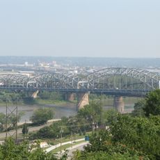
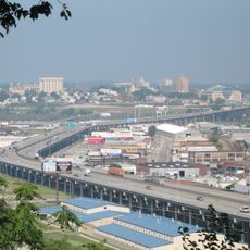
The site lies along the Missouri River bluffs in an open area where visitors can walk and explore the grounds. A marker identifies the location, though the original structures have largely disappeared over time.

Lewis and Clark documented the fort's remains during their historic 1804 expedition across the frontier. They recorded visible chimneys and structural outlines that revealed how the buildings had been arranged.

The community of curious travelers

AroundUs brings together thousands of curated places, local tips, and hidden gems, enriched daily by 60,000 contributors worldwide.

Start exploring
Location
Inception
1744
GPS coordinates
39.10670,-94.67640
Latest update
December 14, 2025 11:03
Around this place
Sauer Castle
United States of America

Sauer Castle

5.6 km
Memorial Hall
United States of America

Memorial Hall

4.3 km
United States of America

Kaw Point

5.8 km
Buck O'Neil Bridge
United States of America

Buck O'Neil Bridge

7.5 km
Cathedral of the Immaculate Conception
United States of America

Cathedral of the Immaculate Conception

7.6 km
Intercity Viaduct
United States of America

Intercity Viaduct

5.4 km
Huron Cemetery
United States of America

Huron Cemetery

4.4 km
Rosedale World War I Memorial Arch
United States of America

Rosedale World War I Memorial Arch

7.1 km
Scottish Rite Temple
United States of America

Scottish Rite Temple

4.4 km
Fairfax Bridge
United States of America

Fairfax Bridge

7.2 km
Vox Theatre
United States of America

Vox Theatre

6.7 km
Platte Purchase Bridge
United States of America

Platte Purchase Bridge

7.2 km
Argentine Carnegie Library
United States of America

Argentine Carnegie Library

3.9 km
United States of America

Imperial Brewing Company Brewery

7.1 km
Fire Station No. 9
United States of America

Fire Station No. 9

2.8 km
Kansas City, Kansas Public Library
United States of America

Kansas City, Kansas Public Library

4.5 km
Highline Bridge
United States of America

Highline Bridge

6.2 km
A. Porter Davis Residence
United States of America

A. Porter Davis Residence

4.2 km
I-670 Viaduct
United States of America

I-670 Viaduct

5.6 km
Usine North American de Kansas City
United States of America

Usine North American de Kansas City

7.1 km
Shawnee Street Overpass
United States of America

Shawnee Street Overpass

6.2 km
Wyandotte County Courthouse
United States of America

Wyandotte County Courthouse

4.3 km
Union Pacific Intermodal Bridge
United States of America

Union Pacific Intermodal Bridge

5.6 km
Kansas City Terminal Railway Company Roundhouse Historic District
United States of America

Kansas City Terminal Railway Company Roundhouse Historic District

7.2 km
Turner Bridge
United States of America

Turner Bridge

3.3 km
Argentine Connection Bridge
United States of America

Argentine Connection Bridge

6.8 km
National Airline History Museum
United States of America

National Airline History Museum

6.7 km
Missouri Pacific Bridge
United States of America

Missouri Pacific Bridge

5.6 km
Show the full map
« Fort de Cavagnal - French trading fort near Kansas City, United States » is provided by Around Us (aroundus.com). Images and texts are derived from Wikimedia project under a Creative Commons license. You are allowed to copy, distribute, and modify copies of this page, under the conditions set by the license, as long as this note is clearly visible.

Discover hidden gems everywhere you go!

From secret cafés to breathtaking viewpoints, skip the crowded tourist spots and find places that match your style. Our app makes it easy with voice search, smart filtering, route optimization, and insider tips from travelers worldwide. Download now for the complete mobile experience.

Around Us App Screenshot

A unique approach to discovering new places

Le Figaro

All the places worth exploring

France Info

A tailor-made excursion in just a few clicks

20 Minutes

Around Us
Travel Guide & Maps
Download

Send to your phone

QR Code
1

Open the camera app on your mobile.

2

Point at the QR code with your camera. A notification will appear.

3

Tap the notification to open the link.