Enable Location

We need your location to show you interesting places around you

Discover nearby places

Find interesting locations and hidden gems around you

Precise directions

Get accurate directions and distances to places

Your location is never shared with other users. It's only used when you tap the location button.

Mount Nonotuck

Log in to your account

Start exploring — it's free

Trusted by 62,487 travelers worldwide

Continue with Google
Continue with Apple
or

We will send you a code to connect

By continuing, you accept our Terms and Conditions and our Privacy Policy

Check your inbox

We've sent a pincode in your inbox. Please enter the code below.

Mount Nonotuck

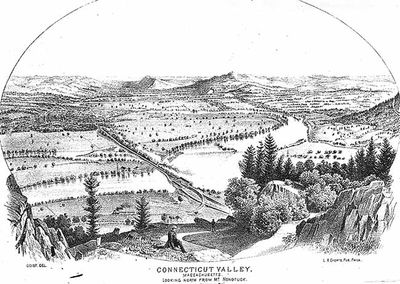
Mount Nonotuck, Mountain summit in Massachusetts, United States

Mount Nonotuck is a summit that rises 827 feet above the Connecticut River Valley, featuring steep basalt cliffs wrapped in dense forest. The dark rock formations create a striking prominence in the landscape and form a distinct ridge line against the sky.

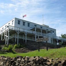
A hotel called the Eyrie House operated on the mountain from 1861 until 1901, making it a destination for visitors in the 1800s. The building was destroyed by fire during an unusual incident involving the attempted cremation of horses.

Local tribes valued this summit as a lookout point and resource site along the river corridor for generations. The steep rock faces and forested slopes remain defining features that connect visitors to how people once used these heights.

The route to the summit follows the Metacomet-Monadnock Trail, a marked hiking path that climbs through forested slopes and rocky sections. Good footwear and care near the steeper cliff edges are necessary for a safe visit.

The basalt rock composition creates distinct microclimates at different elevations and slope angles on the mountain. These conditions allow plant species to grow here that are found rarely or not at all elsewhere in the state.

The community of curious travelers

AroundUs brings together thousands of curated places, local tips, and hidden gems, enriched daily by 60,000 contributors worldwide.

Start exploring
Location
Made from material
igneous rock
GPS coordinates
42.28065,-72.62037
Latest update
December 12, 2025 14:20
Around this place
Mount Tom
United States of America

Mount Tom

4.9 km
Mount Holyoke
United States of America

Mount Holyoke

3.5 km
Dinosaur Footprints Reservation
United States of America

Dinosaur Footprints Reservation

4.3 km
Calvin Coolidge Presidential Library and Museum
United States of America

Calvin Coolidge Presidential Library and Museum

4.2 km
J. A. Skinner State Park
United States of America

J. A. Skinner State Park

3.7 km
Calvin Coolidge House
United States of America

Calvin Coolidge House

5.4 km
Iron Horse Music Hall
United States of America

Iron Horse Music Hall

4.4 km
Smith College Museum of Art
United States of America

Smith College Museum of Art

4.5 km
United States of America

Beer Can Museum

4 km
Calvin Coolidge Bridge
United States of America

Calvin Coolidge Bridge

6.2 km
Academy of Music Theatre
United States of America

Academy of Music Theatre

4.2 km
Mount Holyoke College Art Museum
United States of America

Mount Holyoke College Art Museum

4.7 km
Mount Holyoke College Botanic Garden
United States of America

Mount Holyoke College Botanic Garden

4.7 km
Smith Alumnae Gymnasium
United States of America

Smith Alumnae Gymnasium

4.3 km
Hockanum Rural Historic District
United States of America

Hockanum Rural Historic District

2.6 km
Woodbridge Street Historic District
United States of America

Woodbridge Street Historic District

4.3 km
The Manse
United States of America

The Manse

4.8 km
Fort Hill Historic District
United States of America

Fort Hill Historic District

3.7 km
Main Street Historic District
United States of America

Main Street Historic District

4.5 km
Building at 8–22 Graves Avenue
United States of America

Building at 8–22 Graves Avenue

4.7 km
United States Post Office–Easthampton Main
United States of America

United States Post Office–Easthampton Main

4.4 km
Shepherd and Damon Parsons Houses Historic District
United States of America

Shepherd and Damon Parsons Houses Historic District

4.7 km
Pomeroy Terrace Historic District
United States of America

Pomeroy Terrace Historic District

4.7 km
United States Post Office–South Hadley Main
United States of America

United States Post Office–South Hadley Main

4.4 km
Nashawannuck Mills Historic District
United States of America

Nashawannuck Mills Historic District

4.2 km
Mount Tom State Reservation
United States of America

Mount Tom State Reservation

1.4 km
Norwottuck Rail Trail Bridge
United States of America

Norwottuck Rail Trail Bridge

6.3 km
John M. Greene Hall
United States of America

John M. Greene Hall

4.6 km
Show the full map
« Mount Nonotuck - Mountain summit in Massachusetts, United States » is provided by Around Us (aroundus.com). Images and texts are derived from Wikimedia project under a Creative Commons license. You are allowed to copy, distribute, and modify copies of this page, under the conditions set by the license, as long as this note is clearly visible.

Discover hidden gems everywhere you go!

From secret cafés to breathtaking viewpoints, skip the crowded tourist spots and find places that match your style. Our app makes it easy with voice search, smart filtering, route optimization, and insider tips from travelers worldwide. Download now for the complete mobile experience.

Around Us App Screenshot

A unique approach to discovering new places

Le Figaro

All the places worth exploring

France Info

A tailor-made excursion in just a few clicks

20 Minutes

Around Us
Travel Guide & Maps
Download

Send to your phone

QR Code
1

Open the camera app on your mobile.

2

Point at the QR code with your camera. A notification will appear.

3

Tap the notification to open the link.