Enable Location

We need your location to show you interesting places around you

Discover nearby places

Find interesting locations and hidden gems around you

Precise directions

Get accurate directions and distances to places

Your location is never shared with other users. It's only used when you tap the location button.

Missisquoi National Wildlife Refuge

Log in to your account

Start exploring — it's free

Trusted by 62,533 travelers worldwide

Continue with Google
Continue with Apple
or

We will send you a code to connect

By continuing, you accept our Terms and Conditions and our Privacy Policy

Check your inbox

We've sent a pincode in your inbox. Please enter the code below.

Missisquoi National Wildlife Refuge

Missisquoi National Wildlife Refuge, National Wildlife Refuge and Ramsar site in Franklin County, Vermont.

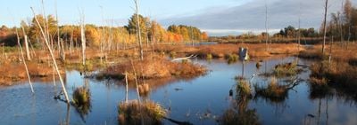
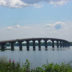
Missisquoi National Wildlife Refuge is a protected area of wetlands, grasslands, and forests along the eastern shore of Lake Champlain near the Canadian border. The refuge includes river deltas and water areas that provide habitat for many bird species and other wildlife, with several public trails for visitors to explore.

The refuge was created in 1943 to protect migrating bird species under federal conservation laws. Over time, the protected area has grown and became important for preserving wetlands in this region near the Vermont-Canada border.

The refuge is a place where you can watch water birds and other animals in their natural home. Walking the public trails, you see how wetlands support different species and understand why people work to protect these areas.

The refuge is accessible by boat through two landing points, with hunting and fishing subject to seasonal restrictions. Visitors should check regulations before visiting and bring clothing suitable for changing weather conditions in this wetland environment.

An island within the refuge holds Vermont's largest nesting colony of great blue herons with hundreds of nests. This bird colony draws nature watchers during breeding season when visitors can spot the birds from the water areas and trails.

The community of curious travelers

AroundUs brings together thousands of curated places, local tips, and hidden gems, enriched daily by 60,000 contributors worldwide.

Start exploring
Location
Inception
February 4, 1943
GPS coordinates
44.96670,-73.16670
Latest update
December 12, 2025 14:20
Around this place
Fort Montgomery
United States of America

Fort Montgomery

15 km
Rouses Point–Lacolle 223 Border Crossing
Canada

Rouses Point–Lacolle 223 Border Crossing

16.8 km
Missisquoi Valley Union Middle/High School
United States of America

Missisquoi Valley Union Middle/High School

6.7 km
Fort Sainte Anne
Canada

Fort Sainte Anne

16.1 km
Rouses Point Bridge
United States of America

Rouses Point Bridge

14.7 km
Lacolle Mills Blockhouse
Canada

Lacolle Mills Blockhouse

17.9 km
Warner Home
United States of America

Warner Home

18 km
Isle La Motte Light
United States of America

Isle La Motte Light

15.5 km
Holy Trinity Episcopal Church
United States of America

Holy Trinity Episcopal Church

6.4 km
Rockledge
United States of America

Rockledge

12.7 km
St. Albans Historic District
United States of America

St. Albans Historic District

18.4 km
Methodist Episcopal Church
United States of America

Methodist Episcopal Church

6.3 km
United Methodist Church of Isle La Motte
United States of America

United Methodist Church of Isle La Motte

16.8 km
Houghton House
United States of America

Houghton House

18.9 km
Hathaway's Tavern
United States of America

Hathaway's Tavern

17.3 km
Central Vermont Railroad Headquarters
United States of America

Central Vermont Railroad Headquarters

18.4 km
Douglas & Jarvis Patent Parabolic Truss Iron Bridge
United States of America

Douglas & Jarvis Patent Parabolic Truss Iron Bridge

10 km
Swanton Covered Railroad Bridge
United States of America

Swanton Covered Railroad Bridge

10 km
Rutland Railroad Pumping Station
United States of America

Rutland Railroad Pumping Station

11.3 km
L'Ecole Saintes-Anges
United States of America

L'Ecole Saintes-Anges

18.2 km
Bridge 9
United States of America

Bridge 9

16.5 km
Ira Hill House
United States of America

Ira Hill House

16.8 km
Giroux Furniture Company Building
United States of America

Giroux Furniture Company Building

18.5 km
Richwood Estate
United States of America

Richwood Estate

12.8 km
St. Albans Town Hall
United States of America

St. Albans Town Hall

17.8 km
Swanton School
United States of America

Swanton School

6.6 km
Église Saint-George de Clarenceville
Canada

Église Saint-George de Clarenceville

12.5 km
Philipsburg United Church
Canada

Philipsburg United Church

11 km
Show the full map
« Missisquoi National Wildlife Refuge - National Wildlife Refuge and Ramsar site in Franklin County, Vermont » is provided by Around Us (aroundus.com). Images and texts are derived from Wikimedia project under a Creative Commons license. You are allowed to copy, distribute, and modify copies of this page, under the conditions set by the license, as long as this note is clearly visible.

Discover hidden gems everywhere you go!

From secret cafés to breathtaking viewpoints, skip the crowded tourist spots and find places that match your style. Our app makes it easy with voice search, smart filtering, route optimization, and insider tips from travelers worldwide. Download now for the complete mobile experience.

Around Us App Screenshot

A unique approach to discovering new places

Le Figaro

All the places worth exploring

France Info

A tailor-made excursion in just a few clicks

20 Minutes

Around Us
Travel Guide & Maps
Download

Send to your phone

QR Code
1

Open the camera app on your mobile.

2

Point at the QR code with your camera. A notification will appear.

3

Tap the notification to open the link.