Enable Location

We need your location to show you interesting places around you

Discover nearby places

Find interesting locations and hidden gems around you

Precise directions

Get accurate directions and distances to places

Your location is never shared with other users. It's only used when you tap the location button.

Adairs Covered Bridge

Log in to your account

Start exploring — it's free

Trusted by 62,437 travelers worldwide

Continue with Google
Continue with Apple
or

We will send you a code to connect

By continuing, you accept our Terms and Conditions and our Privacy Policy

Check your inbox

We've sent a pincode in your inbox. Please enter the code below.

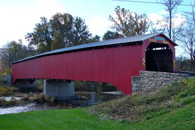
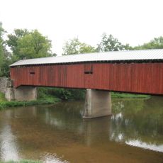
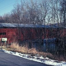
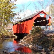
Adairs Covered Bridge, historic wooden covered bridge located at Southwest Madison Township, Pennsylvania, United States

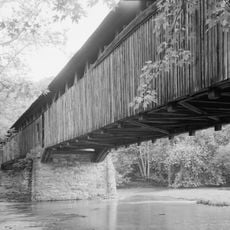
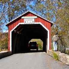
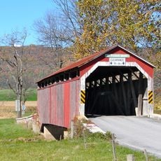
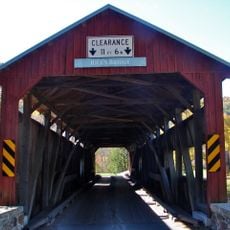
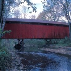
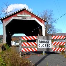
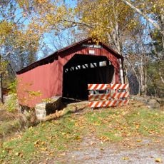
Adairs Covered Bridge is a wooden structure in Southwest Madison Township that spans Sherman's Creek with a roof and side walls protecting the timber frame. The bridge uses a Burr Truss design with arches and beams to support weight, measuring approximately 150 feet in length with a single driving lane.

The bridge was built in 1864 as a timber structure for rural communities in Pennsylvania. It underwent major repairs in 1919 and was added to the National Register of Historic Places in 1980 to protect its historical significance.

Access to the bridge is straightforward from local roads with simple parking nearby on quiet streets. Visit during daylight hours to see the wooden details clearly, and watch your footing on the old timber surface which can be uneven in places.

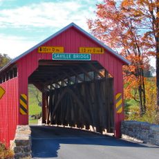
The bridge is also known as Cisna Mill Covered Bridge, a name derived from local families and places in the area. This alternate name reflects how the structure was woven into the community's daily life and connections across generations.

The community of curious travelers

AroundUs brings together thousands of curated places, local tips, and hidden gems, enriched daily by 60,000 contributors worldwide.

Start exploring
Inception
1864
GPS coordinates
40.35025,-77.42419
Latest update
February 9, 2026 11:06
Around this place
Carlisle Indian Industrial School
United States of America

Carlisle Indian Industrial School

26.2 km
Port Royal Speedway
United States of America

Port Royal Speedway

20.9 km
Little Buffalo State Park
United States of America

Little Buffalo State Park

24.1 km
Colonel Denning State Park
United States of America

Colonel Denning State Park

8.6 km
Fowlers Hollow State Park
United States of America

Fowlers Hollow State Park

15.8 km
Academia Pomeroy Covered Bridge
United States of America

Academia Pomeroy Covered Bridge

16.5 km
Old West, Dickinson College
United States of America

Old West, Dickinson College

25.4 km
Dellville Covered Bridge
United States of America

Dellville Covered Bridge

26.1 km
New Germantown Covered Bridge
United States of America

New Germantown Covered Bridge

13.2 km
State Game Lands Number 256
United States of America

State Game Lands Number 256

25.3 km
Ramp Covered Bridge
United States of America

Ramp Covered Bridge

25.3 km
Perry County Courthouse
United States of America

Perry County Courthouse

21.5 km
Book's Covered Bridge
United States of America

Book's Covered Bridge

9 km
Carlisle Armory
United States of America

Carlisle Armory

25.4 km
Mount Pleasant Covered Bridge
United States of America

Mount Pleasant Covered Bridge

11 km
Rice Covered Bridge
United States of America

Rice Covered Bridge

9.9 km
Saville Covered Bridge
United States of America

Saville Covered Bridge

10.1 km
Bistline Covered Bridge
United States of America

Bistline Covered Bridge

4.3 km
Kochendefer Covered Bridge
United States of America

Kochendefer Covered Bridge

8.8 km
Waggoner Covered Bridge
United States of America

Waggoner Covered Bridge

4.5 km
Lehman's, Port Royal Covered Bridge
United States of America

Lehman's, Port Royal Covered Bridge

20.1 km
Newville Historic District
United States of America

Newville Historic District

19.8 km
Dunbar-Creigh House
United States of America

Dunbar-Creigh House

10 km
Little Buffalo Historic District
United States of America

Little Buffalo Historic District

24.5 km
Israel and Samuel Lupfer Tannery Site and House
United States of America

Israel and Samuel Lupfer Tannery Site and House

12 km
Big Spring State Forest Picnic Area
United States of America

Big Spring State Forest Picnic Area

21.5 km
James Given Tavern
United States of America

James Given Tavern

25.6 km
O'Donel House and Farm
United States of America

O'Donel House and Farm

18.5 km
Show the full map
« Adairs Covered Bridge - historic wooden covered bridge located at Southwest Madison Township, Pennsylvania, United States » is provided by Around Us (aroundus.com). Images and texts are derived from Wikimedia project under a Creative Commons license. You are allowed to copy, distribute, and modify copies of this page, under the conditions set by the license, as long as this note is clearly visible.

Discover hidden gems everywhere you go!

From secret cafés to breathtaking viewpoints, skip the crowded tourist spots and find places that match your style. Our app makes it easy with voice search, smart filtering, route optimization, and insider tips from travelers worldwide. Download now for the complete mobile experience.

Around Us App Screenshot

A unique approach to discovering new places

Le Figaro

All the places worth exploring

France Info

A tailor-made excursion in just a few clicks

20 Minutes

Around Us
Travel Guide & Maps
Download

Send to your phone

QR Code
1

Open the camera app on your mobile.

2

Point at the QR code with your camera. A notification will appear.

3

Tap the notification to open the link.