Chest opened
+${chestReward.xp} XP
Explorer
NOUVEAU ×${chestReward.collectible.quantity}
tapez pour fermer
Chest locked

Open chests in the app

Around Us is built for your phone — chests unlock when you walk, explore and capture nearby places.

Enable Location

We need your location to show you interesting places around you

Discover nearby places

Find interesting locations and hidden gems around you

Precise directions

Get accurate directions and distances to places

Your location is never shared with other users. It's only used when you tap the location button.

Log in to your account

Start exploring — it's free

Trusted by 72,893 travelers worldwide

Continue with Google
Continue with Apple
or

We will send you a code to connect

By continuing, you accept our Terms and Conditions and our Privacy Policy

Check your inbox

We've sent a pincode in your inbox. Please enter the code below.

Archie
Discussion Reviews Photo
1.4k Popularity

Archie, Rural community in Cass County, Missouri, United States

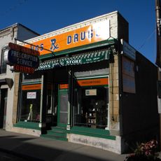
Archie is a small community in southern Cass County, Missouri, with residential areas surrounding the central Main Street district. The town has a typical small-town structure with local businesses and services clustered in the center.

The town was founded in 1880 and named after Archie Talmadge, whose father was a railroad official during the city's early development. The founding was tied to railroad expansion in the region.

The high school basketball tournament draws teams and spectators from across the region for nearly 90 years and shapes community life. This yearly event remains an important gathering for residents and strengthens local connections.

City Hall at 401 South Main Street serves as the main administrative center and provides information about the community. Visitors can stop there to ask about local services and upcoming events.

A meteorite that fell near the town in 1932 is now displayed at the Smithsonian National Museum of Natural History in Washington, D.C. This celestial object became part of the museum's major scientific collections.

The community of curious travelers

AroundUs brings together thousands of curated places, local tips, and hidden gems, enriched daily by 60,000 contributors worldwide.

Start exploring
Location
GPS coordinates
38.50000,-94.30000
Latest update
December 14, 2025 17:02
Around this place
United Methodist Church of the Resurrection
United States of America

United Methodist Church of the Resurrection

51.7 km
Sprint World Headquarters Campus
United States of America

Sprint World Headquarters Campus

56.1 km
Blue Valley Northwest High School
United States of America

Blue Valley Northwest High School

55.7 km
Bannister Federal Complex
United States of America

Bannister Federal Complex

56.1 km
Blue Valley West High School
United States of America

Blue Valley West High School

50.6 km
Longview Farm
United States of America

Longview Farm

46.9 km
Hillsdale Lake
United States of America

Hillsdale Lake

55.4 km
Powell Gardens
United States of America

Powell Gardens

47.1 km
United States of America

Overland Park Arboretum and Botanical Gardens

47.7 km
Harry S. Truman Farm Home
United States of America

Harry S. Truman Farm Home

49 km
United States of America

Marine Corps Individual Reserve Support Activity

44.6 km
United States of America

Powell Observatory

38.4 km
United States of America

Fort Carondelet

52.1 km
Marais des Cygnes National Wildlife Refuge
United States of America

Marais des Cygnes National Wildlife Refuge

43.2 km
Trailside Center
United States of America

Trailside Center

55.6 km
Saint Paul's Episcopal Church
United States of America

Saint Paul's Episcopal Church

46.2 km
Jackson Hotel
United States of America

Jackson Hotel

51.1 km
Harrisonville Courthouse Square Historic District
United States of America

Harrisonville Courthouse Square Historic District

17.7 km
Bates County Courthouse
United States of America

Bates County Courthouse

27.4 km
Papinville Marais des Cygnes River Bridge
United States of America

Papinville Marais des Cygnes River Bridge

48.4 km
Miami County Courthouse
United States of America

Miami County Courthouse

51 km
Glasgow Commercial Historic District
United States of America

Glasgow Commercial Historic District

49.9 km
Mine Creek Bridge
United States of America

Mine Creek Bridge

52.8 km
Marjorie Powell Allen Chapel
United States of America

Marjorie Powell Allen Chapel

47.3 km
Henry County Museum
United States of America

Henry County Museum

47.7 km
Marais des Cygnes Massacre Site
United States of America

Marais des Cygnes Massacre Site

37.1 km
Deer Creek Golf Course
United States of America

Deer Creek Golf Course

53.9 km
Asylum Bridge
United States of America

Asylum Bridge

55.9 km
Show the full map
Reviews
Share your experience

No review yet

Discussions
Start a discussion...

No discussion yet

« Archie - Rural community in Cass County, Missouri, United States » is provided by Around Us (aroundus.com). Images and texts are derived from Wikimedia project under a Creative Commons license. You are allowed to copy, distribute, and modify copies of this page, under the conditions set by the license, as long as this note is clearly visible.

Discover hidden gems everywhere you go!

From secret cafés to breathtaking viewpoints, skip the crowded tourist spots and find places that match your style. Our app makes it easy with voice search, smart filtering, route optimization, and insider tips from travelers worldwide. Download now for the complete mobile experience.

Around Us App Screenshot

A unique approach to discovering new places

Le Figaro

All the places worth exploring

France Info

A tailor-made excursion in just a few clicks

20 Minutes

Around Us
Travel Guide & Maps
Download

Send to your phone

QR Code
1

Open the camera app on your mobile.

2

Point at the QR code with your camera. A notification will appear.

3

Tap the notification to open the link.