Enable Location

We need your location to show you interesting places around you

Discover nearby places

Find interesting locations and hidden gems around you

Precise directions

Get accurate directions and distances to places

Your location is never shared with other users. It's only used when you tap the location button.

Arney's Mount Friends Meetinghouse and Burial Ground

Log in to your account

Start exploring — it's free

Trusted by 62,315 travelers worldwide

Continue with Google
Continue with Apple
or

We will send you a code to connect

By continuing, you accept our Terms and Conditions and our Privacy Policy

Check your inbox

We've sent a pincode in your inbox. Please enter the code below.

Arney's Mount Friends Meetinghouse and Burial Ground

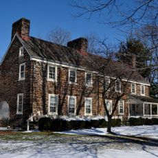
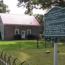
Arney's Mount Friends Meetinghouse and Burial Ground, United States historic place

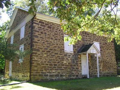
Arney's Mount Friends Meetinghouse is a small stone building erected in 1775 in Springfield Township, New Jersey, built to serve as a gathering place for Quakers. The structure has rough, unpainted ironstone walls with irregularly spaced windows, and the interior features galleries on three sides that could be opened or closed with hand-hewn wooden panels.

The building was constructed in 1775 by Samuel Smith using local stone and was one of the few early stone meetinghouses in the area. After fires around 1800 and 1809, it was carefully restored, and in 1941 the community revived its use.

The name Arney's Mount comes from Arney Lippincott, an early landowner whose family was connected to the place. The Quakers who gathered here valued simplicity and humility, which shows in the plain stone walls and lack of decoration.

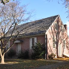
The site has no electricity or running water, with a wood stove providing warmth in winter and oil lamps offering light. A brick privy from the 1930s on the grounds serves as the toilet facility without modern conveniences.

A datestone on the wall carries the names 'S. Smith' and 'I. Coate', which was unusual among Quakers who typically avoided displaying pride. This suggests these men felt proud of their craftsmanship and contribution to the building.

The community of curious travelers

AroundUs brings together thousands of curated places, local tips, and hidden gems, enriched daily by 60,000 contributors worldwide.

Start exploring
Architectural style
vernacular architecture
GPS coordinates
40.00920,-74.69720
Latest update
February 9, 2026 08:19
Around this place
Pennsbury Manor
United States of America

Pennsbury Manor

15 km
Burlington Island
United States of America

Burlington Island

15.6 km
United States Air Force Expeditionary Center
United States of America

United States Air Force Expeditionary Center

7.8 km
Burlington County Prison
United States of America

Burlington County Prison

8 km
Bordentown School
United States of America

Bordentown School

14.9 km
St. Mary's Episcopal Church
United States of America

St. Mary's Episcopal Church

15.9 km
Rancocas State Park
United States of America

Rancocas State Park

13.6 km
Smithville, Burlington County, New Jersey
United States of America

Smithville, Burlington County, New Jersey

5.1 km
United States of America

Burlington County Courthouse

7.9 km
Burlington Historic District
United States of America

Burlington Historic District

16.2 km
Zurbrugg Mansion
United States of America

Zurbrugg Mansion

7.3 km
Francis Hopkinson House
United States of America

Francis Hopkinson House

15.6 km
First Presbyterian Church
United States of America

First Presbyterian Church

7.6 km
Shinn Curtis Log House
United States of America

Shinn Curtis Log House

7.9 km
Peachfield
United States of America

Peachfield

9.4 km
Old Upper Springfield Friends Burying Ground
United States of America

Old Upper Springfield Friends Burying Ground

6.1 km
Quaker School
United States of America

Quaker School

15.7 km
Lewis W. Barton Arboretum
United States of America

Lewis W. Barton Arboretum

15.4 km
Bishop-Irick Farmstead
United States of America

Bishop-Irick Farmstead

8.8 km
Brainerd School
United States of America

Brainerd School

7.8 km
Providence Presbyterian Church of Bustleton
United States of America

Providence Presbyterian Church of Bustleton

11.5 km
Morris Mansion and Mill
United States of America

Morris Mansion and Mill

4.4 km
Kirby's Mill
United States of America

Kirby's Mill

13.9 km
Fernbrook Historic District
United States of America

Fernbrook Historic District

10.7 km
Roebling Historic District
United States of America

Roebling Historic District

13.7 km
Arneytown Historic District
United States of America

Arneytown Historic District

15.1 km
Pemberton Historic District
United States of America

Pemberton Historic District

4.5 km
Mount Holly Historic District
United States of America

Mount Holly Historic District

7.9 km
Show the full map
« Arney's Mount Friends Meetinghouse and Burial Ground - United States historic place » is provided by Around Us (aroundus.com). Images and texts are derived from Wikimedia project under a Creative Commons license. You are allowed to copy, distribute, and modify copies of this page, under the conditions set by the license, as long as this note is clearly visible.

Discover hidden gems everywhere you go!

From secret cafés to breathtaking viewpoints, skip the crowded tourist spots and find places that match your style. Our app makes it easy with voice search, smart filtering, route optimization, and insider tips from travelers worldwide. Download now for the complete mobile experience.

Around Us App Screenshot

A unique approach to discovering new places

Le Figaro

All the places worth exploring

France Info

A tailor-made excursion in just a few clicks

20 Minutes

Around Us
Travel Guide & Maps
Download

Send to your phone

QR Code
1

Open the camera app on your mobile.

2

Point at the QR code with your camera. A notification will appear.

3

Tap the notification to open the link.