Enable Location

We need your location to show you interesting places around you

Discover nearby places

Find interesting locations and hidden gems around you

Precise directions

Get accurate directions and distances to places

Your location is never shared with other users. It's only used when you tap the location button.

Ashland Dam and Spillway

Log in to your account

Start exploring — it's free

Trusted by 62,560 travelers worldwide

Continue with Google
Continue with Apple
or

We will send you a code to connect

By continuing, you accept our Terms and Conditions and our Privacy Policy

Check your inbox

We've sent a pincode in your inbox. Please enter the code below.

Ashland Dam and Spillway, United States historic place

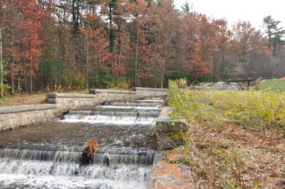
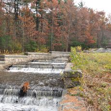
Ashland Dam and Spillway is an earthen embankment dam located at the northern end of Ashland Reservoir in Ashland, Massachusetts. The structure consists of a roughly 83-foot tall earth dam with a concrete core and a 630-foot spillway made of granite and concrete with stepped sections designed to guide overflow water.

The facility was constructed in 1885 as part of Boston's second major water supply project to extract drinking water from the Sudbury River. The gatehouse that once crowned the dam was removed in 1976 following vandalism, and the site was added to the National Register of Historic Places in 1990.

The name reflects the dam's original purpose as a water storage facility for Boston's needs. Visitors can observe how the spillway was designed to resemble a natural stream flowing through the landscape, revealing how engineers of that era sought to integrate their structures with the surrounding environment.

The site is accessible via West Union Street with parking available for visitors. The area around the dam is easy to navigate with gentle slopes, making it suitable for a relaxed walk to observe the spillway and surrounding water views.

The spillway was deliberately designed to resemble a natural stream, with granite steps extending over 630 feet down the slope. This approach was unusual for infrastructure projects of the 1880s and demonstrates how engineers of that era sought to balance practical function with landscape aesthetics.

The community of curious travelers

AroundUs brings together thousands of curated places, local tips, and hidden gems, enriched daily by 60,000 contributors worldwide.

Start exploring
Location
GPS coordinates
42.24611,-71.46028
Latest update
February 9, 2026 07:45
Around this place
New England Compounding Center meningitis outbreak
United States of America

New England Compounding Center meningitis outbreak

4.1 km
Sri Lakshmi Temple
United States of America

Sri Lakshmi Temple

2.9 km
Hopkinton State Park
United States of America

Hopkinton State Park

5.4 km
Ashland State Park
United States of America

Ashland State Park

826 m
Danforth Museum
United States of America

Danforth Museum

5.2 km
Framingham Reservoir No. 1 Dam and Gatehouse
United States of America

Framingham Reservoir No. 1 Dam and Gatehouse

5.3 km
First Baptist Church
United States of America

First Baptist Church

6.3 km
Framingham Centre Common Historic District
United States of America

Framingham Centre Common Historic District

6.7 km
Thomas Hollis Historic District
United States of America

Thomas Hollis Historic District

6.1 km
Joseph Twitchell House
United States of America

Joseph Twitchell House

5.1 km
Concord Square Historic District
United States of America

Concord Square Historic District

5 km
Ashland Town House
United States of America

Ashland Town House

1.7 km
East Holliston Historic District
United States of America

East Holliston Historic District

4.9 km
Moses Ellis House
United States of America

Moses Ellis House

6.6 km
South Union School
United States of America

South Union School

6.3 km
Richard Sanger III House
United States of America

Richard Sanger III House

6.7 km
Isaac Bullard House
United States of America

Isaac Bullard House

2.8 km
Irving Square Historic District
United States of America

Irving Square Historic District

4.8 km
Clark-Northrup House
United States of America

Clark-Northrup House

6.1 km
Sawin-Bullen-Bullard House
United States of America

Sawin-Bullen-Bullard House

4.8 km
Addington Gardner House
United States of America

Addington Gardner House

6.1 km
Eleazer Goulding House
United States of America

Eleazer Goulding House

4.5 km
Asa Sanger House
United States of America

Asa Sanger House

6.6 km
Charles D. Lewis House
United States of America

Charles D. Lewis House

6.4 km
Joseph Cleale House
United States of America

Joseph Cleale House

4.5 km
Bullen-Stratton-Cozzen House
United States of America

Bullen-Stratton-Cozzen House

4.9 km
Boston Paint Ball
United States of America

Boston Paint Ball

2.7 km
Morse-Tay-Leland-Hawes House
United States of America

Morse-Tay-Leland-Hawes House

5.5 km
Show the full map
« Ashland Dam and Spillway - United States historic place » is provided by Around Us (aroundus.com). Images and texts are derived from Wikimedia project under a Creative Commons license. You are allowed to copy, distribute, and modify copies of this page, under the conditions set by the license, as long as this note is clearly visible.

Discover hidden gems everywhere you go!

From secret cafés to breathtaking viewpoints, skip the crowded tourist spots and find places that match your style. Our app makes it easy with voice search, smart filtering, route optimization, and insider tips from travelers worldwide. Download now for the complete mobile experience.

Around Us App Screenshot

A unique approach to discovering new places

Le Figaro

All the places worth exploring

France Info

A tailor-made excursion in just a few clicks

20 Minutes

Around Us
Travel Guide & Maps
Download

Send to your phone

QR Code
1

Open the camera app on your mobile.

2

Point at the QR code with your camera. A notification will appear.

3

Tap the notification to open the link.