Chest opened
+${chestReward.xp} XP
Explorer
NOUVEAU ×${chestReward.collectible.quantity}
tapez pour fermer
Chest locked

Open chests in the app

Around Us is built for your phone — chests unlock when you walk, explore and capture nearby places.

Enable Location

We need your location to show you interesting places around you

Discover nearby places

Find interesting locations and hidden gems around you

Precise directions

Get accurate directions and distances to places

Your location is never shared with other users. It's only used when you tap the location button.

Bailey Island

Log in to your account

Start exploring — it's free

Trusted by 72,876 travelers worldwide

Continue with Google
Continue with Apple
or

We will send you a code to connect

By continuing, you accept our Terms and Conditions and our Privacy Policy

Check your inbox

We've sent a pincode in your inbox. Please enter the code below.

Bailey Island
Discussion Reviews 2 Photos
21.6k Popularity

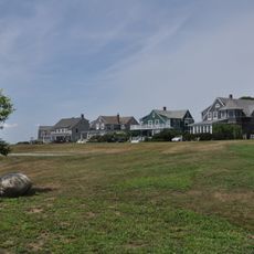
Bailey Island, Coastal island in Cumberland County, Maine

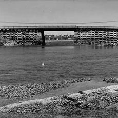
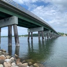
Bailey Island is a granite island in Cumberland County, Maine, connected to Orr's Island by the Cribstone Bridge. This unusual bridge has wide gaps between its stones that allow boats to pass underneath when the tides permit.

The Abenaki people originally called the island Newaggin before Reverend Timothy Bailey purchased and settled it in 1742. Since then, it developed into a center for fishing and maritime activities.

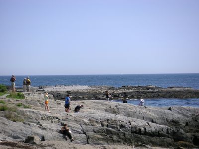
The working harbor at Mackerel Cove shapes daily life, where fishing boats come and go with the tides and locals practice skills passed down through generations. This rhythm of work on the water shows how fishing remains at the heart of the community.

The island is reachable by car from Brunswick, about 15 miles away, or by boat from Portland, roughly 50 miles to the south. The warmer months work best for visiting, when roads are dry and boat tours run regularly.

The island gained global attention in July 2020 when it was the site of Maine's first documented fatal shark encounter, involving a great white shark. This rare incident highlighted how ocean predators have expanded their range into northern waters.

The community of curious travelers

AroundUs brings together thousands of curated places, local tips, and hidden gems, enriched daily by 60,000 contributors worldwide.

Start exploring
Elevation above the sea
22 m
GPS coordinates
43.73750,-69.99361
Latest update
December 7, 2025 10:04
Around this place
Eartha
United States of America

Eartha

15.8 km
Bailey Island Bridge
United States of America

Bailey Island Bridge

1.4 km
Halfway Rock Light
United States of America

Halfway Rock Light

9.7 km
Popham Beach State Park
United States of America

Popham Beach State Park

15.6 km
Wolfe's Neck Woods State Park
United States of America

Wolfe's Neck Woods State Park

12.2 km
Pennellville Historic District
United States of America

Pennellville Historic District

14.1 km
Bailey Island Library Hall
United States of America

Bailey Island Library Hall

573 m
Elijah Kellogg Church
United States of America

Elijah Kellogg Church

6.9 km
Winslow Memorial Park
United States of America

Winslow Memorial Park

12.1 km
Pettengill House and Farm
United States of America

Pettengill House and Farm

14.4 km
East Harpswell Free Will Baptist Church
United States of America

East Harpswell Free Will Baptist Church

13.9 km
Harraseeket Historic District
United States of America

Harraseeket Historic District

15.1 km
Ellis C. Snodgrass Memorial Bridge
United States of America

Ellis C. Snodgrass Memorial Bridge

13.1 km
E.B. Mallett Office Building
United States of America

E.B. Mallett Office Building

15.9 km
Union Church
United States of America

Union Church

9.5 km
Auburn-Harpswell Association Historic District
United States of America

Auburn-Harpswell Association Historic District

1.7 km
Joseph and Susan Manley Summer Cottage
United States of America

Joseph and Susan Manley Summer Cottage

12.7 km
Elijah Kellogg House
United States of America

Elijah Kellogg House

11.1 km
Capt. Greenfield Pote House
United States of America

Capt. Greenfield Pote House

12.6 km
Ropes End
United States of America

Ropes End

12.7 km
Deacon Andrew Dunning House
United States of America

Deacon Andrew Dunning House

9.4 km
James Pennell Mansion
United States of America

James Pennell Mansion

13.8 km
Tarr-Eaton House
United States of America

Tarr-Eaton House

7 km
Wallace-Haskell Homestead
United States of America

Wallace-Haskell Homestead

10.9 km
Percy District School House
United States of America

Percy District School House

15.8 km
Gilman Manse
United States of America

Gilman Manse

15.7 km
USS S-21
United States of America

USS S-21

13.7 km
Head Beach
United States of America

Head Beach

11.7 km
Show the full map
Reviews
Share your experience

No review yet

Discussions
Start a discussion...

No discussion yet

« Bailey Island - Coastal island in Cumberland County, Maine » is provided by Around Us (aroundus.com). Images and texts are derived from Wikimedia project under a Creative Commons license. You are allowed to copy, distribute, and modify copies of this page, under the conditions set by the license, as long as this note is clearly visible.

Discover hidden gems everywhere you go!

From secret cafés to breathtaking viewpoints, skip the crowded tourist spots and find places that match your style. Our app makes it easy with voice search, smart filtering, route optimization, and insider tips from travelers worldwide. Download now for the complete mobile experience.

Around Us App Screenshot

A unique approach to discovering new places

Le Figaro

All the places worth exploring

France Info

A tailor-made excursion in just a few clicks

20 Minutes

Around Us
Travel Guide & Maps
Download

Send to your phone

QR Code
1

Open the camera app on your mobile.

2

Point at the QR code with your camera. A notification will appear.

3

Tap the notification to open the link.