
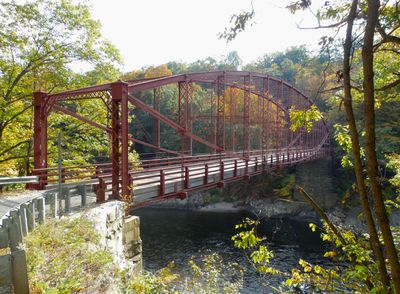
Bardwell's Ferry Bridge
Bardwell's Ferry Bridge, Lenticular truss bridge in Conway, Massachusetts.
The Bardwell's Ferry Bridge extends 198 feet across the Deerfield River, connecting the towns of Shelburne and Conway through a metal structure with thirteen panels.
Built in 1882 by the Berlin Iron Bridge Company of East Berlin, Connecticut, this bridge replaced a covered wooden structure that strong winds had destroyed earlier that year.
This engineering landmark reflects the evolution of American transportation infrastructure, marking the transition from ferry services that operated since Gideon Bardwell Jr. in 1777.
The bridge deck measures 14 feet wide with wooden planks, while the structure can support approximately 3 tons of weight for vehicular passage.
The structure stands as the longest single-span lenticular bridge in Massachusetts, featuring built-up open box members made from riveted plates and angles.
Location: Massachusetts
Inception: 1882
GPS coordinates: 42.55560,-72.67810
Latest update: March 7, 2025 19:21
Bridge of Flowers
7.4 km
Historic Deerfield
6.1 km
Poet's Seat Tower
8.7 km
Shelburne Falls Trolley Museum
7 km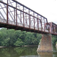
Canalside Rail Trail Bridge
8.9 km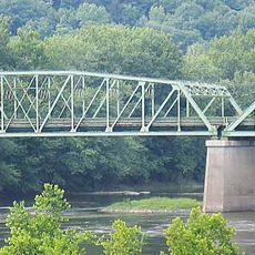
General Pierce Bridge
8.5 km
Dedic Site
5.7 km
Pocumtuck Ridge Trail
7.9 km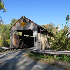
Burkeville Covered Bridge
6 km
Main Street Historic District
7.2 km
The Wilder Homestead
9.6 km
Leavitt-Hovey House
7.4 km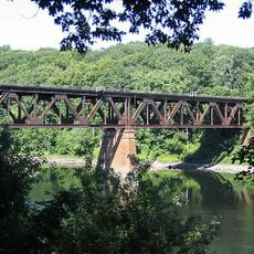
Springfield Terminal railroad bridge, Deerfield
10 km
Garden Theater Block
7.3 km
Old Tavern Farm
8.2 km
Robert Strong Woodward House and Studio
10.3 km
Odd Fellows' Hall
7.4 km
United States Post Office–Greenfield Main
7.5 km
Ashfield Plain Historic District
9.6 km
East Main-High Street Historic District
7.6 km
Maj. Joseph Griswold House
10.1 km
Conway Center Historic District
5.5 km
Shelburne Free Public Library
3.8 km
Massaemett Mountain
7.8 km
Montague City Covered Bridge
8.5 km
Chapel Brook Falls
10.5 km
Guiding Star Grange
8.3 km
East Shelburne Cemetery
6.2 kmReviews
Visited this place? Tap the stars to rate it and share your experience / photos with the community! Try now! You can cancel it anytime.
Discover hidden gems everywhere you go!
From secret cafés to breathtaking viewpoints, skip the crowded tourist spots and find places that match your style. Our app makes it easy with voice search, smart filtering, route optimization, and insider tips from travelers worldwide. Download now for the complete mobile experience.

A unique approach to discovering new places❞
— Le Figaro
All the places worth exploring❞
— France Info
A tailor-made excursion in just a few clicks❞
— 20 Minutes