Enable Location

We need your location to show you interesting places around you

Discover nearby places

Find interesting locations and hidden gems around you

Precise directions

Get accurate directions and distances to places

Your location is never shared with other users. It's only used when you tap the location button.

Beechdale Bridge

Log in to your account

Start exploring — it's free

Trusted by 62,823 travelers worldwide

Continue with Google
Continue with Apple
or

We will send you a code to connect

By continuing, you accept our Terms and Conditions and our Privacy Policy

Check your inbox

We've sent a pincode in your inbox. Please enter the code below.

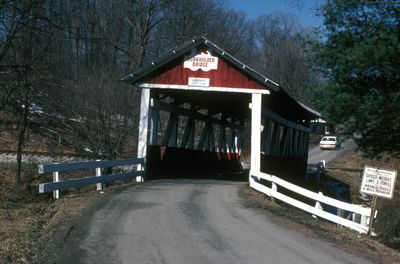
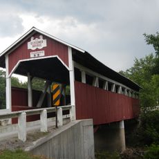
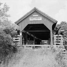
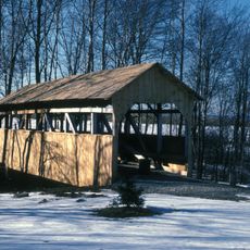
Beechdale Bridge, Covered bridge in Brothersvalley Township, Somerset County, US.

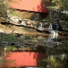
Beechdale Bridge is a covered bridge crossing Buffalo Creek in Brothersvalley Township, built with low sidewalls that offer clear views of the wooden structural elements. The structure continues to carry vehicles on Township Route 548 while maintaining its original timber construction and design details.

The bridge was built in 1870 using the Burr truss design, representing 19th-century engineering methods for transportation infrastructure in Pennsylvania. Its historical significance led to its listing on the National Register of Historic Places in 1980.

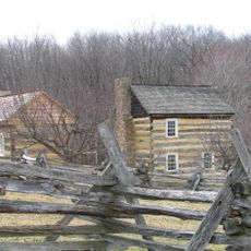
The bridge stands among ten remaining covered bridges in Somerset County, reflecting the region's dedication to preserving historical transportation structures.

The bridge sits in a rural area and is easily accessed via Township Route 548, with low walls offering good views of the surroundings. Access is available anytime since the bridge remains actively used as a roadway.

The structure spans 0.1 acres and features architectural elements that earned its inclusion in the National Register of Historic Places in December 1980.

The community of curious travelers

AroundUs brings together thousands of curated places, local tips, and hidden gems, enriched daily by 60,000 contributors worldwide.

Start exploring
Location
GPS coordinates
39.88170,-79.03470
Latest update
December 14, 2025 18:42
Around this place
Flight 93 National Memorial
United States of America

Flight 93 National Memorial

22.3 km
Mount Davis
United States of America

Mount Davis

16.2 km
Laurel Hill State Park
United States of America

Laurel Hill State Park

24.1 km
Pennsylvania Railroad 3750
United States of America

Pennsylvania Railroad 3750

15.5 km
Casselman Bridge
United States of America

Casselman Bridge

22.6 km
Salisbury Viaduct
United States of America

Salisbury Viaduct

5.4 km
Somerset County Courthouse
United States of America

Somerset County Courthouse

14.7 km
Wills Creek Bollman Bridge
United States of America

Wills Creek Bollman Bridge

7.8 km
Daniel B. Zimmerman Mansion
United States of America

Daniel B. Zimmerman Mansion

15.9 km
Glessner Bridge
United States of America

Glessner Bridge

18.7 km
Somerset Historical Center
United States of America

Somerset Historical Center

21.4 km
Barronvale Bridge
United States of America

Barronvale Bridge

21.6 km
Uptown Somerset Historic District
United States of America

Uptown Somerset Historic District

14.8 km
Packsaddle Bridge
United States of America

Packsaddle Bridge

18.6 km
King's Bridge
United States of America

King's Bridge

21.1 km
Fuller-Baker Log House
United States of America

Fuller-Baker Log House

23.8 km
Mount Savage Historic District
United States of America

Mount Savage Historic District

24.5 km
Stanton's Mill
United States of America

Stanton's Mill

22.5 km
Walter's Mill Bridge
United States of America

Walter's Mill Bridge

20.8 km
Second National Bank of Meyersdale
United States of America

Second National Bank of Meyersdale

7.5 km
Penrose Wolf Building
United States of America

Penrose Wolf Building

11.1 km
Wall of Names
United States of America

Wall of Names

22 km
Western Overlook Trail
United States of America

Western Overlook Trail

22.1 km
Flight 93 National Memorial Visitor Center
United States of America

Flight 93 National Memorial Visitor Center

22.4 km
Flight 93 National Memorial Visitor Shelter
United States of America

Flight 93 National Memorial Visitor Shelter

22 km
Wetlands Bridge
United States of America

Wetlands Bridge

22.3 km
Laurel Hill RDA
United States of America

Laurel Hill RDA

21.7 km
Deer Valley Kissing Bridge
United States of America

Deer Valley Kissing Bridge

17.1 km
Show the full map
« Beechdale Bridge - Covered bridge in Brothersvalley Township, Somerset County, US » is provided by Around Us (aroundus.com). Images and texts are derived from Wikimedia project under a Creative Commons license. You are allowed to copy, distribute, and modify copies of this page, under the conditions set by the license, as long as this note is clearly visible.

Discover hidden gems everywhere you go!

From secret cafés to breathtaking viewpoints, skip the crowded tourist spots and find places that match your style. Our app makes it easy with voice search, smart filtering, route optimization, and insider tips from travelers worldwide. Download now for the complete mobile experience.

Around Us App Screenshot

A unique approach to discovering new places

Le Figaro

All the places worth exploring

France Info

A tailor-made excursion in just a few clicks

20 Minutes

Around Us
Travel Guide & Maps
Download

Send to your phone

QR Code
1

Open the camera app on your mobile.

2

Point at the QR code with your camera. A notification will appear.

3

Tap the notification to open the link.