Enable Location

We need your location to show you interesting places around you

Discover nearby places

Find interesting locations and hidden gems around you

Precise directions

Get accurate directions and distances to places

Your location is never shared with other users. It's only used when you tap the location button.

Bellevue Bridge

Log in to your account

Start exploring — it's free

Trusted by travelers worldwide

Continue with Google
Continue with Apple
or

We will send you a code to connect

By continuing, you accept our Terms and Conditions and our Privacy Policy

Check your inbox

We've sent a pincode in your inbox. Please enter the code below.

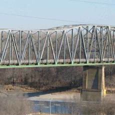
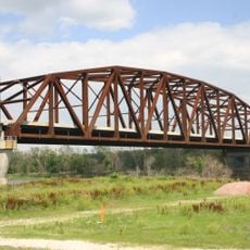
Bellevue Bridge, Toll bridge connecting Sarpy County, Nebraska to Mills County, Iowa.

Description

Bellevue Bridge is a truss bridge that crosses the Missouri River between Nebraska and Iowa, connecting Sarpy County to Mills County. The structure spans the river and serves as a vehicle crossing, maintaining its function as a regional transportation link.

History

The bridge was built in 1950 by the Bellevue Bridge Commission to improve transportation connections between the two states. After another bridge opened downstream on the Missouri River, this crossing's role was adjusted to serve as a connection between Nebraska Highway 370 and Iowa Highway 370.

Culture

The bridge serves as a daily crossing for commuters and travelers moving between the two states, making it part of the routine for people living near the Missouri River. It represents a practical link between communities rather than a monument, reflecting how these border regions depend on such connections for everyday life.

Practical

Drivers must pay a toll to cross the bridge, with funds going toward maintenance of the structure. When planning a crossing, visitors should expect it to be busy during commute times, especially on weekdays.

Did you know?

The bridge carries the name of the Grand Army of the Republic, a historic organization of war veterans that held significance in this region. This naming choice reflects how the local community honored the veterans and their influence on the area's development.

Location
Location
Official opening
1950
GPS coordinates
41.13860,-95.87920
Latest update
December 12, 2025 14:23

AroundUs brings together thousands of curated places, local tips, and hidden gems, enriched daily by 60,000 contributors worldwide. Discover all places nearby (Nebraska).

Around this place
Omaha’s Henry Doorly Zoo and Aquarium
United States of America

Omaha’s Henry Doorly Zoo and Aquarium

10.4 km
Lauritzen Gardens
United States of America

Lauritzen Gardens

11.4 km
Sokol Auditorium
United States of America

Sokol Auditorium

12 km
United States of America

Horseshoe Council Bluffs

11.3 km
Kenefick Park
United States of America

Kenefick Park

10.9 km
Fontenelle Forest
United States of America

Fontenelle Forest

5.6 km
Joel N. Cornish House
United States of America

Joel N. Cornish House

12.6 km
St. Frances Cabrini Catholic Church
United States of America

St. Frances Cabrini Catholic Church

12.6 km
South Omaha Veterans Memorial Bridge
United States of America

South Omaha Veterans Memorial Bridge

9.4 km
Rosewater School
United States of America

Rosewater School

10.5 km
Immaculate Conception Church and School
United States of America

Immaculate Conception Church and School

12 km
El Museo Latino
United States of America

El Museo Latino

10 km
Log Cabin
United States of America

Log Cabin

1.1 km
St. Joseph Parish Complex
United States of America

St. Joseph Parish Complex

12.5 km
Vinton Street Commercial Historic District
United States of America

Vinton Street Commercial Historic District

11.7 km
St. Martin of Tours Episcopal Church
United States of America

St. Martin of Tours Episcopal Church

10.2 km
Presbyterian Church
United States of America

Presbyterian Church

1.2 km
Pony Creek Park
United States of America

Pony Creek Park

10.8 km
Vinton School
United States of America

Vinton School

11.4 km
Packer's National Bank Building
United States of America

Packer's National Bank Building

9.6 km
Robbins School
United States of America

Robbins School

11.7 km
Fontenelle Bank
United States of America

Fontenelle Bank

1 km
Sandwich–Marseilles Manufacturing Building
United States of America

Sandwich–Marseilles Manufacturing Building

12.6 km
William E. Gordon House
United States of America

William E. Gordon House

2.4 km
William Hamilton House
United States of America

William Hamilton House

747 m
Mount Vernon Gardens
United States of America

Mount Vernon Gardens

8 km
RailsWest Railroad Museum
United States of America

RailsWest Railroad Museum

12.3 km
South Omaha Veterans Memorial Bridge
United States of America

South Omaha Veterans Memorial Bridge

9 km
Show the full map
« Bellevue Bridge - Toll bridge connecting Sarpy County, Nebraska to Mills County, Iowa » is provided by Around Us (aroundus.com). Images and texts are derived from Wikimedia project under a Creative Commons license. You are allowed to copy, distribute, and modify copies of this page, under the conditions set by the license, as long as this note is clearly visible.

Discover hidden gems everywhere you go!

From secret cafés to breathtaking viewpoints, skip the crowded tourist spots and find places that match your style. Our app makes it easy with voice search, smart filtering, route optimization, and insider tips from travelers worldwide. Download now for the complete mobile experience.

Around Us App Screenshot

A unique approach to discovering new places

Le Figaro

All the places worth exploring

France Info

A tailor-made excursion in just a few clicks

20 Minutes

Around Us
Travel Guide & Maps
Download

Send to your phone

QR Code
1

Open the camera app on your mobile.

2

Point at the QR code with your camera. A notification will appear.

3

Tap the notification to open the link.