Fort Blue Mounds

Log in to your account

AroundUs is a community-driven map of interesting places, built by curious explorers like you. It grows with every review, story, and photo you share.
Connect to save your favorite spots, contribute locations, and create personalized routes.
By continuing, you accept our Terms and Conditions and our Privacy Policy
Add to collection
Map
Suggest a change
Share

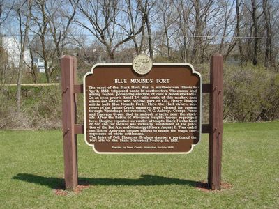
Fort Blue Mounds, Archaeological site in Blue Mounds, United States

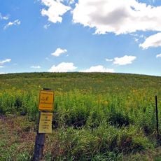
Fort Blue Mounds is an archaeological site in Wisconsin where settlers built a defensive structure with wooden stockade walls and two blockhouses at opposite corners. The fortification was positioned on elevated ground to provide strategic views across the surrounding landscape.

The fort was built in 1832 during a period of tensions between settlers and Native American groups in the region. This structure represented early military responses to conflicts that shaped frontier communities.

The fort shows how early settlers built their defensive structures in the Wisconsin area and how these buildings reflected their views about safety and land boundaries.

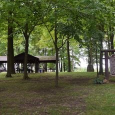
The site is maintained by the Wisconsin Historical Society and requires advance contact for access. The original location is not freely open to visitors, so it is best to arrange visits ahead of time.

The blockhouses and stockade walls here represent some of the few surviving examples of early American frontier fortifications from this era. The combination of natural landforms and human construction makes this location particularly valuable for understanding both archaeology and military history.

Location: Blue Mounds

Inception: May 10, 1832

GPS coordinates: 43.01750,-89.83222

Latest update: December 12, 2025 12:06

Photos
Around this place
Cave of the Mounds
United States of America

Cave of the Mounds

1.3 km
Blue Mound State Park
United States of America

Blue Mound State Park

2 km
Little Norway, Wisconsin
United States of America

Little Norway, Wisconsin

3.6 km
Pleasant Valley Conservancy State Natural Area
United States of America

Pleasant Valley Conservancy State Natural Area

10 km
Black Earth Rettenmund Prairie State Natural Area
United States of America

Black Earth Rettenmund Prairie State Natural Area

14.4 km
Hauge Log Church
United States of America

Hauge Log Church

9.8 km
Brigham County Park
United States of America

Brigham County Park

1.7 km
Herman B. and Anne Marie Dahle House
United States of America

Herman B. and Anne Marie Dahle House

7.7 km
Hoff Department Store
United States of America

Hoff Department Store

7.8 km
Hyde Chapel
United States of America

Hyde Chapel

12.4 km
Heiney's Meat Market
United States of America

Heiney's Meat Market

15 km
John Sweet Donald Farmstead
United States of America

John Sweet Donald Farmstead

13.3 km
Aslak Lie Cabin
United States of America

Aslak Lie Cabin

13.4 km
Henry L. and Sarah Dahle House
United States of America

Henry L. and Sarah Dahle House

8 km
Plum Grove Primitive Methodist Church
United States of America

Plum Grove Primitive Methodist Church

16.2 km
Onon B. and Betsy Dahle House
United States of America

Onon B. and Betsy Dahle House

11.4 km
Thomas Stone Barn
United States of America

Thomas Stone Barn

7.5 km
Roberts House
United States of America

Roberts House

5.2 km
Harris House
United States of America

Harris House

5.4 km
Grove Street Historic District
United States of America

Grove Street Historic District

5.5 km
Cassidy Farmhouse
United States of America

Cassidy Farmhouse

4.7 km
Eric and Jerome Skindrud Farm
United States of America

Eric and Jerome Skindrud Farm

11.7 km
Gulbrand and Bertha Jensvold House
United States of America

Gulbrand and Bertha Jensvold House

11.8 km
Kittleson House
United States of America

Kittleson House

5.3 km
Black Earth Public Library
United States of America

Black Earth Public Library

15 km
Mazomanie Free Library
United States of America

Mazomanie Free Library

17.9 km
Mount Horeb Public Library
United States of America

Mount Horeb Public Library

9.1 km
Mount Horeb Union Cemetery
United States of America

Mount Horeb Union Cemetery

8.4 km
Show the full map
Reviews

Visited this place? Tap the stars to rate it and share your experience / photos with the community! Try now! You can cancel it anytime.

« Fort Blue Mounds - Archaeological site in Blue Mounds, United States » is provided by Around Us (aroundus.com). Images and texts are derived from Wikimedia project under a Creative Commons license. You are allowed to copy, distribute, and modify copies of this page, under the conditions set by the license, as long as this note is clearly visible.

Discover hidden gems everywhere you go!

From secret cafés to breathtaking viewpoints, skip the crowded tourist spots and find places that match your style. Our app makes it easy with voice search, smart filtering, route optimization, and insider tips from travelers worldwide. Download now for the complete mobile experience.

Around Us App Screenshot

A unique approach to discovering new places

Le Figaro

All the places worth exploring

France Info

A tailor-made excursion in just a few clicks

20 Minutes