Chest opened
+${chestReward.xp} XP
Explorer
NOUVEAU ×${chestReward.collectible.quantity}
tapez pour fermer
Chest locked

Open chests in the app

Around Us is built for your phone — chests unlock when you walk, explore and capture nearby places.

Enable Location

We need your location to show you interesting places around you

Discover nearby places

Find interesting locations and hidden gems around you

Precise directions

Get accurate directions and distances to places

Your location is never shared with other users. It's only used when you tap the location button.

Brown Mountain

Log in to your account

Start exploring — it's free

Trusted by 72,983 travelers worldwide

Continue with Google
Continue with Apple
or

We will send you a code to connect

By continuing, you accept our Terms and Conditions and our Privacy Policy

Check your inbox

We've sent a pincode in your inbox. Please enter the code below.

Brown Mountain
Discussion Reviews 1 Photos
11.9k Popularity

Brown Mountain, Mountain in Pisgah National Forest, North Carolina, United States

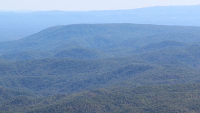
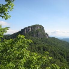
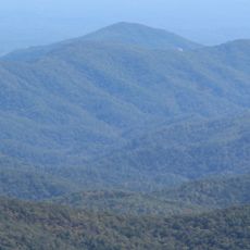
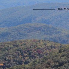
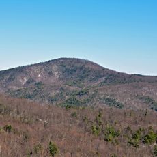
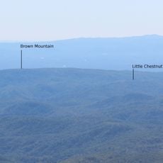
Brown Mountain is a ridge in Pisgah National Forest along the border of Burke and Caldwell Counties, spanning several kilometers through forested terrain. The wooded slopes and steep gorges create a layered landscape, with several viewing areas offering different perspectives of the ridge.

The ridge was documented in early reports from Cherokee and Catawba Indians describing mysterious lights along its slopes. Government interest in these phenomena led to formal investigations that brought scientific attention to the mountain.

The mountain holds deep significance in regional stories passed down through generations, where tales of strange lights have captivated communities for centuries. Visitors encounter a place where scientific curiosity blends naturally with local legend.

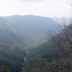
The best time for observation is on clear nights when the lights are most visible, particularly with lower cloud cover. Several marked viewing points like Wisemans View and Lost Cove are accessible and offer good vantage points for watching the phenomenon.

The lights have been known since before European settlement, yet their cause remains unexplained despite scientific study and continues to spark debate among researchers and observers. This ongoing mystery keeps the location intriguing for enthusiasts exploring the phenomenon.

The community of curious travelers

AroundUs brings together thousands of curated places, local tips, and hidden gems, enriched daily by 60,000 contributors worldwide.

Start exploring
Location
Elevation above the sea
762 m
GPS coordinates
35.91580,-81.74580
Latest update
December 7, 2025 20:48
Around this place
Linville Falls
United States of America

Linville Falls

16.8 km
Linville Gorge Wilderness
United States of America

Linville Gorge Wilderness

15.2 km
United States of America

Joara

13.6 km
United States of America

Fort San Juan

10.3 km
Table Rock
United States of America

Table Rock

12.7 km
Edgar Allan Poe House
United States of America

Edgar Allan Poe House

18.5 km
Quaker Meadows
United States of America

Quaker Meadows

17.8 km
Tuttle Educational State Forest
United States of America

Tuttle Educational State Forest

12 km
Adams Mountain
United States of America

Adams Mountain

2.5 km
Lenoir High School
United States of America

Lenoir High School

18.3 km
Bee Mountain
United States of America

Bee Mountain

14.6 km
Nuckolls-Jefferies House
United States of America

Nuckolls-Jefferies House

7.9 km
Chestnut Mountain
United States of America

Chestnut Mountain

7.5 km
Bellevue
United States of America

Bellevue

15.3 km
Mulberry Chapel Methodist Church
United States of America

Mulberry Chapel Methodist Church

8.4 km
Markham-Albertson-Stinson Cottage
United States of America

Markham-Albertson-Stinson Cottage

11 km
Lenoir Downtown Historic District
United States of America

Lenoir Downtown Historic District

18.7 km
Green Park Historic District
United States of America

Green Park Historic District

18.7 km
John Alexander Lackey House
United States of America

John Alexander Lackey House

16.6 km
Little Chestnut Mountain
United States of America

Little Chestnut Mountain

4 km
Alphonse Calhoun Avery House
United States of America

Alphonse Calhoun Avery House

19.3 km
Lenoir Grammar School
United States of America

Lenoir Grammar School

18.9 km
Mary's Grove
United States of America

Mary's Grove

16.4 km
Jacob Forney Jr. House
United States of America

Jacob Forney Jr. House

13.1 km
Caldwell County Courthouse
United States of America

Caldwell County Courthouse

18.6 km
Franklin-Penland House
United States of America

Franklin-Penland House

17.7 km
Sloan-Throneburg Farm
United States of America

Sloan-Throneburg Farm

11.3 km
Mountain Paradise
United States of America

Mountain Paradise

18.4 km
Show the full map
Reviews
Share your experience

No review yet

Discussions
Start a discussion...

No discussion yet

« Brown Mountain - Mountain in Pisgah National Forest, North Carolina, United States » is provided by Around Us (aroundus.com). Images and texts are derived from Wikimedia project under a Creative Commons license. You are allowed to copy, distribute, and modify copies of this page, under the conditions set by the license, as long as this note is clearly visible.

Discover hidden gems everywhere you go!

From secret cafés to breathtaking viewpoints, skip the crowded tourist spots and find places that match your style. Our app makes it easy with voice search, smart filtering, route optimization, and insider tips from travelers worldwide. Download now for the complete mobile experience.

Around Us App Screenshot

A unique approach to discovering new places

Le Figaro

All the places worth exploring

France Info

A tailor-made excursion in just a few clicks

20 Minutes

Around Us
Travel Guide & Maps
Download

Send to your phone

QR Code
1

Open the camera app on your mobile.

2

Point at the QR code with your camera. A notification will appear.

3

Tap the notification to open the link.