Enable Location

We need your location to show you interesting places around you

Discover nearby places

Find interesting locations and hidden gems around you

Precise directions

Get accurate directions and distances to places

Your location is never shared with other users. It's only used when you tap the location button.

Burt County Missouri River Bridge

Log in to your account

Start exploring — it's free

Trusted by travelers worldwide

Continue with Google
Continue with Apple
or

We will send you a code to connect

By continuing, you accept our Terms and Conditions and our Privacy Policy

Check your inbox

We've sent a pincode in your inbox. Please enter the code below.

Burt County Missouri River Bridge

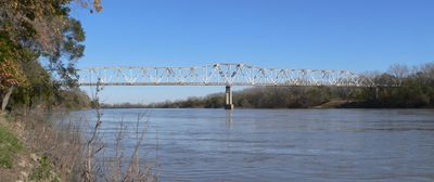
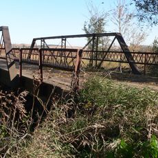
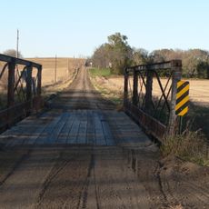
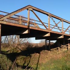
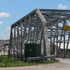
Burt County Missouri River Bridge, Truss bridge in Decatur, Nebraska.

Description

The Burt County Missouri River Bridge is a truss bridge that crosses the Missouri River connecting Decatur, Nebraska and Onawa, Iowa. It features a distinctive metal grillwork floor that gives travelers a direct view of the water below.

History

Construction finished in 1951, but the official opening came in 1955 after the US Army Corps of Engineers completed work on the Missouri River. The delay reflected the need for river management work before the bridge could safely serve both states.

Culture

Local people call this crossing 'That Scary Ass Bridge' because of the metal grillwork floor that lets you see the river directly below. The name reflects how residents experience the mix of wonder and unease when walking or driving over it.

Practical

The bridge is open year-round for traffic in both directions, though the metal grillwork surface can become slippery in wet conditions. Drivers should adjust speed when weather turns rainy or snowy, and the open floor may feel unsettling for those with height concerns.

Did you know?

Until late 2013, this was one of Nebraska's few toll bridges, but became free and is now jointly managed by Nebraska and Iowa. The shift removed a financial barrier for regular travelers between the two states.
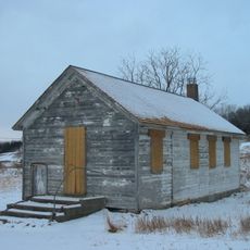
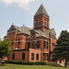
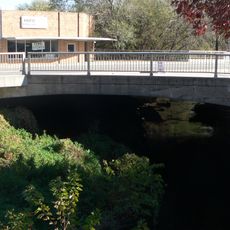
Location
Official opening
1955
GPS coordinates
42.00690,-96.24200
Latest update
December 14, 2025 18:42

AroundUs brings together thousands of curated places, local tips, and hidden gems, enriched daily by 60,000 contributors worldwide. Discover all places nearby (Nebraska).

Around this place
Loess Hills
United States of America

Loess Hills

30.7 km
Dr. Susan LaFlesche Picotte Memorial Hospital
United States of America

Dr. Susan LaFlesche Picotte Memorial Hospital

26.4 km
Lewis and Clark State Park
United States of America

Lewis and Clark State Park

7.3 km
St. John's German Evangelical Lutheran Church
United States of America

St. John's German Evangelical Lutheran Church

20.9 km
Ingemann Danish Lutheran Church
United States of America

Ingemann Danish Lutheran Church

27.2 km
John G. Neihardt State Historic Site
United States of America

John G. Neihardt State Historic Site

27.7 km
Susan La Flesche Picotte House
United States of America

Susan La Flesche Picotte House

26 km
Cornelius O'Connor House
United States of America

Cornelius O'Connor House

38.4 km
Swedish Heritage Center
United States of America

Swedish Heritage Center

26.4 km
Onawa IOOF Opera House
United States of America

Onawa IOOF Opera House

12.2 km
Onawa Public Library
United States of America

Onawa Public Library

12.5 km
H.S.M. Spielman House
United States of America

H.S.M. Spielman House

26.1 km
United States of America

South Jordan Cemetery

29.6 km
Rattlesnake Creek Bridge
United States of America

Rattlesnake Creek Bridge

31 km
Newell A. Whiting House
United States of America

Newell A. Whiting House

12 km
Thurston County Courthouse
United States of America

Thurston County Courthouse

40.4 km
First Thurston County Courthouse
United States of America

First Thurston County Courthouse

40.3 km
E.C. Houston House
United States of America

E.C. Houston House

25.2 km
North Omaha Creek Bridge
United States of America

North Omaha Creek Bridge

31.7 km
Tekamah Carnegie Library
United States of America

Tekamah Carnegie Library

25.7 km
Frank Uehling Barn
United States of America

Frank Uehling Barn

36.9 km
Mann School No. 2
United States of America

Mann School No. 2

25.4 km
Burt County Courthouse
United States of America

Burt County Courthouse

25.5 km
Burt County State Bank
United States of America

Burt County State Bank

25.7 km
Monona County Courthouse
United States of America

Monona County Courthouse

12.6 km
Tekamah City Bridge
United States of America

Tekamah City Bridge

25.7 km
North Omaha Creek Bridge
United States of America

North Omaha Creek Bridge

29.3 km
Logan Creek Bridge
United States of America

Logan Creek Bridge

39.9 km
Show the full map
« Burt County Missouri River Bridge - Truss bridge in Decatur, Nebraska » is provided by Around Us (aroundus.com). Images and texts are derived from Wikimedia project under a Creative Commons license. You are allowed to copy, distribute, and modify copies of this page, under the conditions set by the license, as long as this note is clearly visible.

Discover hidden gems everywhere you go!

From secret cafés to breathtaking viewpoints, skip the crowded tourist spots and find places that match your style. Our app makes it easy with voice search, smart filtering, route optimization, and insider tips from travelers worldwide. Download now for the complete mobile experience.

Around Us App Screenshot

A unique approach to discovering new places

Le Figaro

All the places worth exploring

France Info

A tailor-made excursion in just a few clicks

20 Minutes

Around Us
Travel Guide & Maps
Download

Send to your phone

QR Code
1

Open the camera app on your mobile.

2

Point at the QR code with your camera. A notification will appear.

3

Tap the notification to open the link.