Enable Location

We need your location to show you interesting places around you

Discover nearby places

Find interesting locations and hidden gems around you

Precise directions

Get accurate directions and distances to places

Your location is never shared with other users. It's only used when you tap the location button.

Calumet and Hecla Industrial District

Log in to your account

Start exploring — it's free

Trusted by 61,911 travelers worldwide

Continue with Google
Continue with Apple
or

We will send you a code to connect

By continuing, you accept our Terms and Conditions and our Privacy Policy

Check your inbox

We've sent a pincode in your inbox. Please enter the code below.

Calumet and Hecla Industrial District, Mining district in Calumet, Michigan, US.

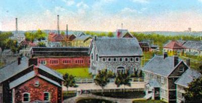
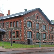
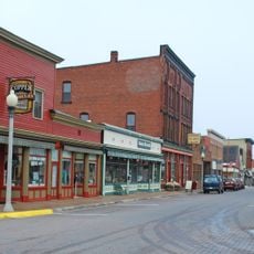
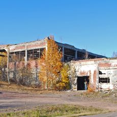
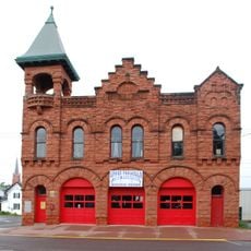
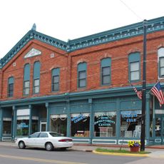
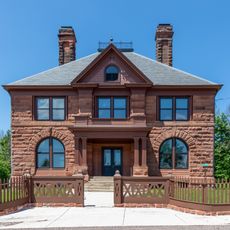
The Calumet and Hecla Industrial District is a mining facility in Michigan's Upper Peninsula that stretches along railroad tracks connecting different mine openings above a copper seam. The site contains ten main buildings, including a machine shop, roundhouse, and general office, constructed between 1880 and 1910.

Alexander Agassiz took control of the mining operation in 1867 and transformed it into one of the world's most productive copper mines. By 1870, the facility was producing more than half of all copper mined in the United States.

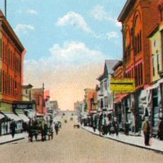
The buildings show how mining operations supported a working community in the harsh Upper Peninsula landscape. You can see the relationship between different structures and imagine how workers moved between the machine shop, offices, and railway facilities throughout their day.

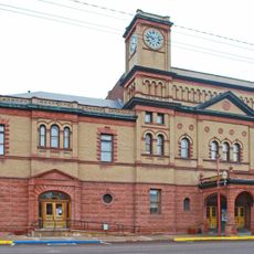
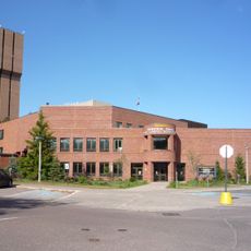
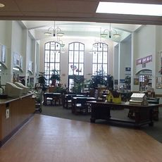
The district is part of the Keweenaw National Historical Park, with the general office building now serving as the visitor center providing information about the site. You can walk through the grounds to see how the historical structures are arranged around the railroad lines.

The roundhouse contains twelve railroad stalls arranged in a 170-degree arc around a central turntable, revealing the scale of locomotive operations needed to move ore and materials. This layout demonstrates how specifically engineered the transportation systems were to support mining activities.

The community of curious travelers

AroundUs brings together thousands of curated places, local tips, and hidden gems, enriched daily by 60,000 contributors worldwide.

Start exploring
Location
GPS coordinates
47.24250,-88.45000
Latest update
December 13, 2025 17:02
Around this place
Keweenaw National Historical Park
United States of America

Keweenaw National Historical Park

12.9 km
Calumet Theatre
United States of America

Calumet Theatre

849 m
McLain State Park
United States of America

McLain State Park

11.9 km
Thomas H. Hoatson House
United States of America

Thomas H. Hoatson House

1 km
Calumet Historic District
United States of America

Calumet Historic District

3 km
Hungarian Falls
United States of America

Hungarian Falls

7.9 km
Quincy Mining Company Stamp Mills Historic District
United States of America

Quincy Mining Company Stamp Mills Historic District

10.7 km
Quincy Mine No. 2 Shaft Hoist House
United States of America

Quincy Mine No. 2 Shaft Hoist House

15.1 km
Temple Jacob
United States of America

Temple Jacob

16 km
Calumet Downtown Historic District
United States of America

Calumet Downtown Historic District

583 m
Calumet Fire Station
United States of America

Calumet Fire Station

648 m
Lake Linden Historic District
United States of America

Lake Linden Historic District

6.4 km
Memorial Union Building
United States of America

Memorial Union Building

15.7 km
Joseph Bosch Building
United States of America

Joseph Bosch Building

6.5 km
Keweenaw Waterway Upper Entrance Light
United States of America

Keweenaw Waterway Upper Entrance Light

13.7 km
Black Creek Nature Sanctuary
United States of America

Black Creek Nature Sanctuary

9.9 km
Ransom B. Shelden House
United States of America

Ransom B. Shelden House

15.6 km
Lake Linden Village Hall and Fire Station
United States of America

Lake Linden Village Hall and Fire Station

6.4 km
First Congregational Church
United States of America

First Congregational Church

6.7 km
Smith-Dengler House
United States of America

Smith-Dengler House

3.1 km
Quincy Mine
United States of America

Quincy Mine

15.1 km
East Hancock
United States of America

East Hancock

15.3 km
Calumet Public Library
United States of America

Calumet Public Library

182 m
John J. Michels House
United States of America

John J. Michels House

15.9 km
Houghton Masonic Temple Building
United States of America

Houghton Masonic Temple Building

16 km
Rozsa Center for the Performing Arts
United States of America

Rozsa Center for the Performing Arts

15.5 km
Laurium Historic District
United States of America

Laurium Historic District

1 km
Quincy Mine Office
United States of America

Quincy Mine Office

15.7 km
Show the full map
« Calumet and Hecla Industrial District - Mining district in Calumet, Michigan, US » is provided by Around Us (aroundus.com). Images and texts are derived from Wikimedia project under a Creative Commons license. You are allowed to copy, distribute, and modify copies of this page, under the conditions set by the license, as long as this note is clearly visible.

Discover hidden gems everywhere you go!

From secret cafés to breathtaking viewpoints, skip the crowded tourist spots and find places that match your style. Our app makes it easy with voice search, smart filtering, route optimization, and insider tips from travelers worldwide. Download now for the complete mobile experience.

Around Us App Screenshot

A unique approach to discovering new places

Le Figaro

All the places worth exploring

France Info

A tailor-made excursion in just a few clicks

20 Minutes

Around Us
Travel Guide & Maps
Download

Send to your phone

QR Code
1

Open the camera app on your mobile.

2

Point at the QR code with your camera. A notification will appear.

3

Tap the notification to open the link.