Campbell Archeological Site

Log in to your account

AroundUs is a community-driven map of interesting places, built by curious explorers like you. It grows with every review, story, and photo you share.
Connect to save your favorite spots, contribute locations, and create personalized routes.
Continue with Google
Continue with Apple
Continue with X
Continue with Facebook
Continue with email
By continuing, you accept our Terms and Conditions and our Privacy Policy
Create an account
Add to collection
Map
Suggest a change
Share

Campbell Archeological Site, Archaeological site in Pemiscot County, Missouri, United States.

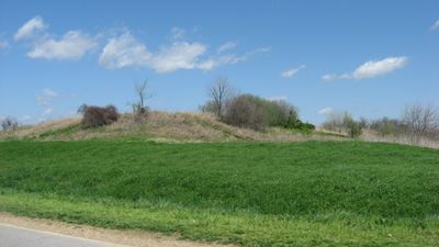
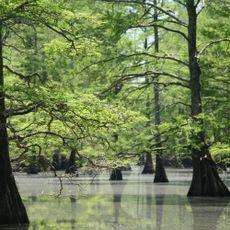
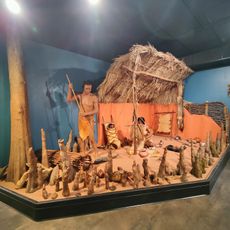
Campbell Archaeological Site is a location with a large platform mound, residential areas, and multiple burial grounds in southeastern Missouri. The area contains extensive remains spread across distinct zones that preserve evidence of how people lived, worked, and honored their dead.

The site was occupied from the late 1300s to the mid-1500s during the Nodena phase of Mississippian culture, representing a significant period in regional history. Federal recognition came in 1974, establishing its importance for understanding the people who lived in this region.

This site was a settlement hub for the Nodena culture, where residents practiced organized burial customs across separate cemetery areas and created distinctive pottery styles. The placement of graves and choice of ceramic types reveal how communities structured their spiritual and daily lives.

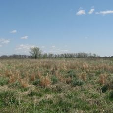
The location sits at the intersection of old drainage ditches, making it accessible to visitors who want to explore the grounds. Comfortable footwear and allowing time to walk through the different zones will enhance your visit to this outdoor site.

Excavations uncovered Spanish-origin items such as glass beads and iron fragments that hint at early trade contact with European visitors. These artifacts suggest the community participated in far-reaching networks that extended beyond regional boundaries.

Location: Missouri

GPS coordinates: 36.04500,-89.79750

Latest update: December 12, 2025 17:43

Photos
Around this place
Fort Pillow State Park
United States of America

Fort Pillow State Park

45.7 km
Caruthersville Bridge
United States of America

Caruthersville Bridge

18.3 km
Alex Haley House and Museum
United States of America

Alex Haley House and Museum

45.9 km
Big Lake National Wildlife Refuge
United States of America

Big Lake National Wildlife Refuge

32.1 km
Eaker Site
United States of America

Eaker Site

15.3 km
Murphy Mound Archeological Site
United States of America

Murphy Mound Archeological Site

15.2 km
United States Highway 61 Arch
United States of America

United States Highway 61 Arch

10.4 km
Herman Davis State Park
United States of America

Herman Davis State Park

38.3 km
Mississippi County Courthouse
United States of America

Mississippi County Courthouse

41.1 km
Edward Moody King House
United States of America

Edward Moody King House

36.6 km
Mississippi County Courthouse
United States of America

Mississippi County Courthouse

16.1 km
Caruthersville Water Tower
United States of America

Caruthersville Water Tower

20.8 km
Kress Building
United States of America

Kress Building

15.7 km
Bank of Osceola
United States of America

Bank of Osceola

41 km
City Hall
United States of America

City Hall

41.2 km
Lauderdale County Courthouse
United States of America

Lauderdale County Courthouse

41.1 km
Osceola Times Building
United States of America

Osceola Times Building

41.1 km
Charles and Bettie Birthright House
United States of America

Charles and Bettie Birthright House

47.7 km
Bank of Dyersburg
United States of America

Bank of Dyersburg

37.1 km
Hale Avenue Historic District
United States of America

Hale Avenue Historic District

41.2 km
West Main Street Residential Historic District
United States of America

West Main Street Residential Historic District

16.7 km
Florida Brothers Building
United States of America

Florida Brothers Building

41.2 km
Caldwell-Hopson House
United States of America

Caldwell-Hopson House

46.6 km
Reelfoot Lake State Park Visitor Center
United States of America

Reelfoot Lake State Park Visitor Center

48.2 km
Chris Tompkins House
United States of America

Chris Tompkins House

28.5 km
Fort Pillow State Historic Park
United States of America

Fort Pillow State Historic Park

46.1 km
Jonesboro, Lake City & Eastern Railroad Steam Locomotive #34 and Associated Rolling Stock
United States of America

Jonesboro, Lake City & Eastern Railroad Steam Locomotive #34 and Associated Rolling Stock

39.7 km
Lenox Bridge
United States of America

Lenox Bridge

32.6 km
Show the full map
Reviews

Visited this place? Tap the stars to rate it and share your experience / photos with the community! Try now! You can cancel it anytime.

« Campbell Archeological Site - Archaeological site in Pemiscot County, Missouri, United States » is provided by Around Us (aroundus.com). Images and texts are derived from Wikimedia project under a Creative Commons license. You are allowed to copy, distribute, and modify copies of this page, under the conditions set by the license, as long as this note is clearly visible.

Discover hidden gems everywhere you go!

From secret cafés to breathtaking viewpoints, skip the crowded tourist spots and find places that match your style. Our app makes it easy with voice search, smart filtering, route optimization, and insider tips from travelers worldwide. Download now for the complete mobile experience.

Around Us App Screenshot

A unique approach to discovering new places

Le Figaro

All the places worth exploring

France Info

A tailor-made excursion in just a few clicks

20 Minutes