United States Highway 61 Arch

Log in to your account

AroundUs is a community-driven map of interesting places, built by curious explorers like you. It grows with every review, story, and photo you share.
Connect to save your favorite spots, contribute locations, and create personalized routes.
Continue with Google
Continue with Apple
Continue with X
Continue with Facebook
Continue with email
By continuing, you accept our Terms and Conditions and our Privacy Policy
Create an account
Add to collection
Map
Suggest a change
Share

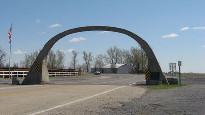
United States Highway 61 Arch, Concrete arch at Arkansas-Missouri state line, United States

The United States Highway 61 Arch is a concrete structure spanning over U.S. Highway 61 at the state line between Arkansas and Missouri. Directional text appears on each side of the arch, clearly indicating which state drivers are entering.

The arch was built in 1924 by the Mississippi County Road Improvement District following the completion of paving on Highway 61 between Blytheville and Steele. This construction reflects the early-20th-century efforts to improve and promote major transportation routes across the country.

The arch serves as a tangible boundary marker that travelers cross when moving between the two states, creating a shared point of reference for communities on both sides. It represents a moment of transition that people experience while journeying through this region.

The structure is easily visible while driving on Highway 61 between the two states. You can read the directional text clearly from your vehicle as you pass through in either direction.

This is the last remaining arched structure spanning a federally designated highway within Arkansas state boundaries. Its solitary status makes it a noteworthy remnant of early highway promotion from that period.

Location: Mississippi County

Location: Pemiscot County

GPS coordinates: 35.99940,-89.89830

Latest update: December 14, 2025 09:44

Photos
Around this place
Fort Pillow State Park
United States of America

Fort Pillow State Park

40.8 km
Caruthersville Bridge
United States of America

Caruthersville Bridge

28.7 km
Big Lake National Wildlife Refuge
United States of America

Big Lake National Wildlife Refuge

21.7 km
Eaker Site
United States of America

Eaker Site

5.2 km
Murphy Mound Archeological Site
United States of America

Murphy Mound Archeological Site

25.1 km
Campbell Archeological Site
United States of America

Campbell Archeological Site

10.4 km
Herman Davis State Park
United States of America

Herman Davis State Park

27.9 km
Mississippi County Courthouse
United States of America

Mississippi County Courthouse

33.6 km
Edward Moody King House
United States of America

Edward Moody King House

45.9 km
Mississippi County Courthouse
United States of America

Mississippi County Courthouse

7.9 km
Caruthersville Water Tower
United States of America

Caruthersville Water Tower

30.6 km
Kress Building
United States of America

Kress Building

8 km
Bank of Osceola
United States of America

Bank of Osceola

33.6 km
City Hall
United States of America

City Hall

33.7 km
Lauderdale County Courthouse
United States of America

Lauderdale County Courthouse

43.6 km
Osceola Times Building
United States of America

Osceola Times Building

33.6 km
Keiser Water Tower
United States of America

Keiser Water Tower

40.1 km
Bank of Dyersburg
United States of America

Bank of Dyersburg

46.3 km
Keiser School
United States of America

Keiser School

40.3 km
Hale Avenue Historic District
United States of America

Hale Avenue Historic District

33.7 km
West Main Street Residential Historic District
United States of America

West Main Street Residential Historic District

8.1 km
Florida Brothers Building
United States of America

Florida Brothers Building

33.7 km
First National Bank Building
United States of America

First National Bank Building

41.8 km
Chris Tompkins House
United States of America

Chris Tompkins House

20.8 km
Fort Pillow State Historic Park
United States of America

Fort Pillow State Historic Park

41 km
Monette Water Tower
United States of America

Monette Water Tower

41.8 km
Jonesboro, Lake City & Eastern Railroad Steam Locomotive #34 and Associated Rolling Stock
United States of America

Jonesboro, Lake City & Eastern Railroad Steam Locomotive #34 and Associated Rolling Stock

30.6 km
Lenox Bridge
United States of America

Lenox Bridge

42.6 km
Show the full map
Reviews

Visited this place? Tap the stars to rate it and share your experience / photos with the community! Try now! You can cancel it anytime.

« United States Highway 61 Arch - Concrete arch at Arkansas-Missouri state line, United States » is provided by Around Us (aroundus.com). Images and texts are derived from Wikimedia project under a Creative Commons license. You are allowed to copy, distribute, and modify copies of this page, under the conditions set by the license, as long as this note is clearly visible.

Discover hidden gems everywhere you go!

From secret cafés to breathtaking viewpoints, skip the crowded tourist spots and find places that match your style. Our app makes it easy with voice search, smart filtering, route optimization, and insider tips from travelers worldwide. Download now for the complete mobile experience.

Around Us App Screenshot

A unique approach to discovering new places

Le Figaro

All the places worth exploring

France Info

A tailor-made excursion in just a few clicks

20 Minutes