Enable Location

We need your location to show you interesting places around you

Discover nearby places

Find interesting locations and hidden gems around you

Precise directions

Get accurate directions and distances to places

Your location is never shared with other users. It's only used when you tap the location button.

Log in to your account

Start exploring — it's free

Trusted by 61,953 travelers worldwide

Continue with Google
Continue with Apple
or

We will send you a code to connect

By continuing, you accept our Terms and Conditions and our Privacy Policy

Check your inbox

We've sent a pincode in your inbox. Please enter the code below.

Chestnut Creek Wetlands Natural Area Preserve

Chestnut Creek Wetlands Natural Area Preserve, Protected wetland area in Floyd County, Virginia.

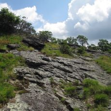
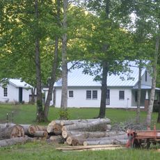
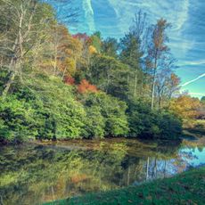
Chestnut Creek Wetlands Natural Area Preserve is a 244-acre protected site in Floyd County featuring spring-fed wetlands, sedge meadows, and northern hardwood forests with beech, birch, and maple trees. The landscape consists mainly of grasses and sedges with scattered woody plants, creating an open terrain dominated by low vegetation.

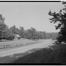
The land was originally used for farming before being acquired through a voter-approved state bond and a recovery grant from the United States Fish and Wildlife Service. This funding allowed the conversion of agricultural land into a protected natural preserve.

The Virginia Department of Conservation and Recreation manages this IUCN category IV habitat, focusing on protecting regional wildlife species and native plant communities.

The preserve has no marked trails or public facilities, so visitors must contact a state land steward in advance to arrange access. Wear sturdy shoes and weather-appropriate clothing since the terrain is wet and can be muddy underfoot.

The preserve supports several rare species that thrive in this wet environment of sedges and grasses, making it a refuge for specialized wildlife. Conservation efforts focus on protecting these distinctive habitats and native plant communities that are scarce elsewhere in the region.

The community of curious travelers

AroundUs brings together thousands of curated places, local tips, and hidden gems, enriched daily by 60,000 contributors worldwide.

Start exploring
Location
GPS coordinates
36.84270,-80.44830
Latest update
December 14, 2025 09:45
Around this place
Buffalo Mountain Natural Area Preserve
United States of America

Buffalo Mountain Natural Area Preserve

5.8 km
Bob White Covered Bridge
United States of America

Bob White Covered Bridge

19.2 km
Jack's Creek Covered Bridge
United States of America

Jack's Creek Covered Bridge

17.9 km
Bugbook Historical Computer Museum
United States of America

Bugbook Historical Computer Museum

13.7 km
Buffalo Mountain Presbyterian Church and Cemetery
United States of America

Buffalo Mountain Presbyterian Church and Cemetery

9.5 km
Cockram Mill
United States of America

Cockram Mill

13.2 km
Slate Mountain Presbyterian Church and Cemetery
United States of America

Slate Mountain Presbyterian Church and Cemetery

8.7 km
Willis Presbyterian Church and Cemetery
United States of America

Willis Presbyterian Church and Cemetery

3.5 km
Floyd Presbyterian Church
United States of America

Floyd Presbyterian Church

13.9 km
Barnard Farm
United States of America

Barnard Farm

23.7 km
Buena Vista Downtown Historic District
United States of America

Buena Vista Downtown Historic District

22.8 km
Dinwiddie Presbyterian Church and Cemetery
United States of America

Dinwiddie Presbyterian Church and Cemetery

24.1 km
Glenanna
United States of America

Glenanna

13.7 km
Cromer House
United States of America

Cromer House

24.3 km
Snake Creek Farm Historic District
United States of America

Snake Creek Farm Historic District

22.8 km
Phlegar Farm
United States of America

Phlegar Farm

15.7 km
West Fork Furnace
United States of America

West Fork Furnace

6.6 km
Floyd Historic District
United States of America

Floyd Historic District

13.8 km
Snowville Christian Church
United States of America

Snowville Christian Church

23.5 km
Bishop House
United States of America

Bishop House

23.7 km
Snowville Historic District
United States of America

Snowville Historic District

23.6 km
Graysontown Methodist Church
United States of America

Graysontown Methodist Church

23.8 km
Grayson-Gravely House
United States of America

Grayson-Gravely House

24.5 km
Groundhog Mountain Tower
United States of America

Groundhog Mountain Tower

23.1 km
Mabry Mill
United States of America

Mabry Mill

10.9 km
Rocky Knob Visitor Center
United States of America

Rocky Knob Visitor Center

9 km
Puckett Cabin
United States of America

Puckett Cabin

23.9 km
Rakes Mill Pond
United States of America

Rakes Mill Pond

14.8 km
Show the full map
« Chestnut Creek Wetlands Natural Area Preserve - Protected wetland area in Floyd County, Virginia » is provided by Around Us (aroundus.com). Images and texts are derived from Wikimedia project under a Creative Commons license. You are allowed to copy, distribute, and modify copies of this page, under the conditions set by the license, as long as this note is clearly visible.

Discover hidden gems everywhere you go!

From secret cafés to breathtaking viewpoints, skip the crowded tourist spots and find places that match your style. Our app makes it easy with voice search, smart filtering, route optimization, and insider tips from travelers worldwide. Download now for the complete mobile experience.

Around Us App Screenshot

A unique approach to discovering new places

Le Figaro

All the places worth exploring

France Info

A tailor-made excursion in just a few clicks

20 Minutes

Around Us
Travel Guide & Maps
Download

Send to your phone

QR Code
1

Open the camera app on your mobile.

2

Point at the QR code with your camera. A notification will appear.

3

Tap the notification to open the link.