Enable Location

We need your location to show you interesting places around you

Discover nearby places

Find interesting locations and hidden gems around you

Precise directions

Get accurate directions and distances to places

Your location is never shared with other users. It's only used when you tap the location button.

Clifton Park

Log in to your account

Start exploring — it's free

Trusted by 62,923 travelers worldwide

Continue with Google
Continue with Apple
or

We will send you a code to connect

By continuing, you accept our Terms and Conditions and our Privacy Policy

Check your inbox

We've sent a pincode in your inbox. Please enter the code below.

Clifton Park
Discussion Reviews 1 Photos
7.9k Popularity

Clifton Park, Urban park and golf course in East Baltimore, United States.

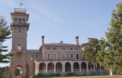
Clifton Park is an urban park with an 18-hole golf course set across rolling terrain, featuring tennis courts and other recreational spaces. The grounds include an Italian villa structure that serves as administrative offices for the property.

Johns Hopkins purchased a working farm at this location in 1838 and developed it into an estate with gardens, a lake, and marble sculptures. Baltimore City acquired the land in 1894 and transformed it into a public park for residents to enjoy.

The park displays a bronze sculpture titled 'On the Trail' by Edward Berge showing an American Indian figure that has stood on the grounds for generations. It serves as a focal point for visitors walking through the landscape and reflects the artistic heritage layered into the space.

The park is bounded by Erdman Avenue to the north, Sinclair Lane to the south, with Harford and Belair Roads marking the western and eastern edges. These clear boundaries make it straightforward for visitors to locate and navigate around the entire property.

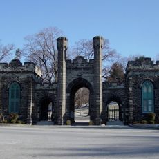
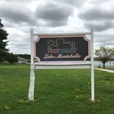
The eight-sided Clifton Gate House from 1887 housed valves for the water pipeline system that supplied water from Lake Montebello. Many visitors overlook this small structure, yet it reveals how the park was once connected to the city's water infrastructure.

The community of curious travelers

AroundUs brings together thousands of curated places, local tips, and hidden gems, enriched daily by 60,000 contributors worldwide.

Start exploring
Location
Operator
Baltimore City Department of Recreation & Parks
GPS coordinates
39.32380,-76.58300
Latest update
December 8, 2025 20:00
Around this place
Morgan State University
United States of America

Morgan State University

2.2 km
Green Mount Cemetery
United States of America

Green Mount Cemetery

2.8 km
Baltimore City College
United States of America

Baltimore City College

1.2 km
Lake Montebello
United States of America

Lake Montebello

917 m
American Brewery Building
United States of America

American Brewery Building

1.6 km
Hughes Stadium
United States of America

Hughes Stadium

2.2 km
Eastern High School
United States of America

Eastern High School

1.5 km
Columbus Obelisk
United States of America

Columbus Obelisk

1.6 km
Talmadge L. Hill Field House
United States of America

Talmadge L. Hill Field House

2.1 km
Baltimore City Archives
United States of America

Baltimore City Archives

2.2 km
East Monument Historic District
United States of America

East Monument Historic District

2.6 km
Sydenham Hospital for Communicable Diseases
United States of America

Sydenham Hospital for Communicable Diseases

1.6 km
Clifton Park Valve House
United States of America

Clifton Park Valve House

612 m
Gompers School
United States of America

Gompers School

1.7 km
St. Wenceslaus in Baltimore
United States of America

St. Wenceslaus in Baltimore

2.6 km
James E. Hooper House
United States of America

James E. Hooper House

3 km
Public School No. 99
United States of America

Public School No. 99

1.4 km
Hurt Gymnasium
United States of America

Hurt Gymnasium

2.3 km
Industrial Building
United States of America

Industrial Building

3.1 km
Old East Baltimore Historic District
United States of America

Old East Baltimore Historic District

2.8 km
Baltimore East/South Clifton Park Historic District
United States of America

Baltimore East/South Clifton Park Historic District

1.7 km
Clifton School
United States of America

Clifton School

1.2 km
Rowhouses at 303-327 East North Avenue
United States of America

Rowhouses at 303-327 East North Avenue

2.9 km
Public School No. 37
United States of America

Public School No. 37

2.2 km
Arcadia–Beverly Hills Historic District
United States of America

Arcadia–Beverly Hills Historic District

1.9 km
Collington Square
United States of America

Collington Square

2 km
Oakenshawe Historic District
United States of America

Oakenshawe Historic District

2.8 km
Northwood Historic District
United States of America

Northwood Historic District

2.4 km
Show the full map
Reviews
Share your experience

No review yet

Discussions
Start a discussion...

No discussion yet

« Clifton Park - Urban park and golf course in East Baltimore, United States » is provided by Around Us (aroundus.com). Images and texts are derived from Wikimedia project under a Creative Commons license. You are allowed to copy, distribute, and modify copies of this page, under the conditions set by the license, as long as this note is clearly visible.

Discover hidden gems everywhere you go!

From secret cafés to breathtaking viewpoints, skip the crowded tourist spots and find places that match your style. Our app makes it easy with voice search, smart filtering, route optimization, and insider tips from travelers worldwide. Download now for the complete mobile experience.

Around Us App Screenshot

A unique approach to discovering new places

Le Figaro

All the places worth exploring

France Info

A tailor-made excursion in just a few clicks

20 Minutes

Around Us
Travel Guide & Maps
Download

Send to your phone

QR Code
1

Open the camera app on your mobile.

2

Point at the QR code with your camera. A notification will appear.

3

Tap the notification to open the link.