Enable Location

We need your location to show you interesting places around you

Discover nearby places

Find interesting locations and hidden gems around you

Precise directions

Get accurate directions and distances to places

Your location is never shared with other users. It's only used when you tap the location button.

Cloquet Valley State Forest

Log in to your account

Start exploring — it's free

Trusted by 61,404 travelers worldwide

Continue with Google
Continue with Apple
or

We will send you a code to connect

By continuing, you accept our Terms and Conditions and our Privacy Policy

Check your inbox

We've sent a pincode in your inbox. Please enter the code below.

Cloquet Valley State Forest

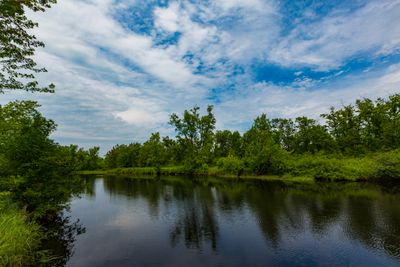
Cloquet Valley State Forest, Minnesota state forest in St. Louis County, United States.

Description

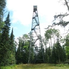
Cloquet Valley State Forest is a large woodland covering more than 327,000 acres across wetlands, river valleys, and higher forest lands in northeastern Minnesota. Extensive trails for hiking and biking connect through the terrain, offering multiple ways to explore the landscape.

History

The forest developed across the valleys of the Ush-kab-wan, Whiteface, and Cloquet rivers, becoming integrated into Minnesota's Arrowhead region as it was formally established. These river systems have shaped the forest's natural structure over time.

Culture

The forest serves both as a recreation area for outdoor enthusiasts and as working land for timber management. This balance between use and conservation shapes how people experience the landscape today.

Practical

The forest is located roughly 20 miles (32 km) north of Duluth and is accessible via County Road 4, which runs north-south through the central area. Camping facilities at Indian Lake serve as a convenient base for exploring the trails and landscape.

Did you know?

The forest hosts rare animals including wolves, lynx, and pine martens that roam the expansive terrain. Its waters support specialized fish species like walleye and musky, making it an important ecosystem for wildlife.

Location
GPS coordinates
47.11310,-92.03520
Latest update
December 14, 2025 11:05

AroundUs brings together thousands of curated places, local tips, and hidden gems, enriched daily by 60,000 contributors worldwide. Discover all places nearby (St. Louis County).

Around this place
Glensheen - Historic Congdon Estate
United States of America

Glensheen - Historic Congdon Estate

33.2 km
Glensheen Historic Estate
United States of America

Glensheen Historic Estate

33.2 km
Edna G
United States of America

Edna G

29.5 km
Two Harbors Lighthouse
United States of America

Two Harbors Lighthouse

30.3 km
John Dwan Office Building
United States of America

John Dwan Office Building

29.4 km
Kitchi Gammi Club
United States of America

Kitchi Gammi Club

35.6 km
Cathedral of Our Lady of the Rosary
United States of America

Cathedral of Our Lady of the Rosary

33.2 km
Oliver G. Traphagen House
United States of America

Oliver G. Traphagen House

34.8 km
Tweed Museum of Art
United States of America

Tweed Museum of Art

33 km
Niagara
United States of America

Niagara

27.4 km
Starkey House
United States of America

Starkey House

33.7 km
Chester Terrace
United States of America

Chester Terrace

35.1 km
Sacred Heart Cathedral, Sacred Heart School and Christian Brothers Home
United States of America

Sacred Heart Cathedral, Sacred Heart School and Christian Brothers Home

36.6 km
Duluth Public Library
United States of America

Duluth Public Library

36.6 km
Two Harbors Breakwater Light
United States of America

Two Harbors Breakwater Light

30 km
Lester River Bridge
United States of America

Lester River Bridge

30.9 km
St. Mark's African Methodist Episcopal Church
United States of America

St. Mark's African Methodist Episcopal Church

35.6 km
Lake County Courthouse and Sheriff's Residence
United States of America

Lake County Courthouse and Sheriff's Residence

29.4 km
Bridge No. 3589
United States of America

Bridge No. 3589

31.5 km
United States of America

Endion School

34.4 km
Duluth Masonic Center
United States of America

Duluth Masonic Center

36.5 km
YWCA of Duluth
United States of America

YWCA of Duluth

36.8 km
Pilgrim Congregational Church
United States of America

Pilgrim Congregational Church

33.7 km
Two Harbors Carnegie Library
United States of America

Two Harbors Carnegie Library

29.4 km
Bridge L8515
United States of America

Bridge L8515

31.7 km
Bridge L6113
United States of America

Bridge L6113

32.8 km
Molde Lookout Tower
United States of America

Molde Lookout Tower

18.5 km
Cotton Lookout Tower
United States of America

Cotton Lookout Tower

36 km
Show the full map
« Cloquet Valley State Forest - Minnesota state forest in St. Louis County, United States » is provided by Around Us (aroundus.com). Images and texts are derived from Wikimedia project under a Creative Commons license. You are allowed to copy, distribute, and modify copies of this page, under the conditions set by the license, as long as this note is clearly visible.

Discover hidden gems everywhere you go!

From secret cafés to breathtaking viewpoints, skip the crowded tourist spots and find places that match your style. Our app makes it easy with voice search, smart filtering, route optimization, and insider tips from travelers worldwide. Download now for the complete mobile experience.

Around Us App Screenshot

A unique approach to discovering new places

Le Figaro

All the places worth exploring

France Info

A tailor-made excursion in just a few clicks

20 Minutes

Around Us
Travel Guide & Maps
Download

Send to your phone

QR Code
1

Open the camera app on your mobile.

2

Point at the QR code with your camera. A notification will appear.

3

Tap the notification to open the link.