Enable Location

We need your location to show you interesting places around you

Discover nearby places

Find interesting locations and hidden gems around you

Precise directions

Get accurate directions and distances to places

Your location is never shared with other users. It's only used when you tap the location button.

Colonial Hotel

Log in to your account

Start exploring — it's free

Trusted by 62,513 travelers worldwide

Continue with Google
Continue with Apple
or

We will send you a code to connect

By continuing, you accept our Terms and Conditions and our Privacy Policy

Check your inbox

We've sent a pincode in your inbox. Please enter the code below.

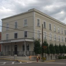
Colonial Hotel, listed on the NRHP in Wise County, Virginia

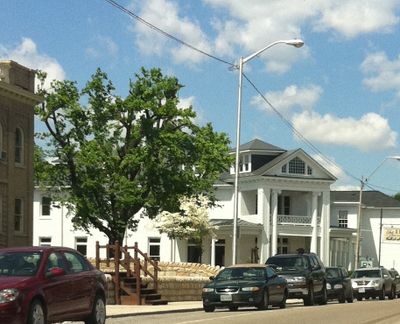
The Colonial Hotel is a brick building built in 1910 in Wise, Virginia, featuring Colonial Revival style with two and a half stories and a U-shaped layout. Its main facade is defined by Ionic columns supporting a triangular pediment, while the side porches were originally open structures until the right side was enclosed during the mid-twentieth century.

The hotel was built in 1910 by local builder D. J. Phipps on a site that had hosted a hotel since just after the Civil War, following the burning of its predecessor, the Dotson Hotel, in 1909. A group of local businesspeople, including a future Virginia governor, worked together to rebuild a hotel on the same location.

The hotel served as a central gathering place for travelers and local residents conducting business in town after it opened in 1910. Its corner location at the intersection of Main Street and Spring Street made it a natural hub for visitors and community events.

The building sits at a prominent corner location near the Wise County Courthouse and is easily visible from nearby streets. Visitors can appreciate the classical architecture from the exterior and recognize the structure as a key landmark in Wise's historic district.

The hotel was financed by a group of local businesspeople that included a future Virginia governor, underscoring its importance to the town's early development. This connection to prominent local leadership reveals how central the building was to the community's future.

The community of curious travelers

AroundUs brings together thousands of curated places, local tips, and hidden gems, enriched daily by 60,000 contributors worldwide.

Start exploring
Location
Inception
1910
GPS coordinates
36.97750,-82.58080
Latest update
February 9, 2026 08:19
Around this place
Black Mountain
United States of America

Black Mountain

28.7 km
United States of America

High Knob

10.4 km
Bad Branch Falls State Nature Preserve
United States of America

Bad Branch Falls State Nature Preserve

19.7 km
Southwest Virginia Museum Historical State Park
United States of America

Southwest Virginia Museum Historical State Park

21.8 km
Ralph Stanley Museum
United States of America

Ralph Stanley Museum

22.1 km
Wise County Courthouse
United States of America

Wise County Courthouse

113 m
June Tolliver House
United States of America

June Tolliver House

21 km
John Fox, Jr. House
United States of America

John Fox, Jr. House

21.5 km
E. M. Fulton House
United States of America

E. M. Fulton House

279 m
Sunnydale Farm
United States of America

Sunnydale Farm

19.8 km
Terrace Park Girl Scout Cabin
United States of America

Terrace Park Girl Scout Cabin

21.7 km
Castlerun Historic District
United States of America

Castlerun Historic District

27.6 km
Devils Fork
United States of America

Devils Fork

18 km
Virginia City Church
United States of America

Virginia City Church

21.8 km
Flat Gap High School
United States of America

Flat Gap High School

15.6 km
Clinch Ranger District Cluster
United States of America

Clinch Ranger District Cluster

16.5 km
Tacoma School
United States of America

Tacoma School

6.4 km
Stonega Historic District
United States of America

Stonega Historic District

18.9 km
Kelly View School
United States of America

Kelly View School

15.6 km
St. Paul Historic District (St. Paul, Virginia)
United States of America

St. Paul Historic District (St. Paul, Virginia)

25.4 km
Dickenson County Courthouse
United States of America

Dickenson County Courthouse

22.1 km
Derby Historic District
United States of America

Derby Historic District

22 km
United States Post Office and Courthouse
United States of America

United States Post Office and Courthouse

21.3 km
Honaker Commercial Historic District
United States of America

Honaker Commercial Historic District

27.6 km
Laurel Fork
United States of America

Laurel Fork

26.7 km
North Fork of the Pound
United States of America

North Fork of the Pound

18.4 km
Mason-Dorton School
United States of America

Mason-Dorton School

32.6 km
Lynch Historic District
United States of America

Lynch Historic District

30 km
Show the full map
« Colonial Hotel - listed on the NRHP in Wise County, Virginia » is provided by Around Us (aroundus.com). Images and texts are derived from Wikimedia project under a Creative Commons license. You are allowed to copy, distribute, and modify copies of this page, under the conditions set by the license, as long as this note is clearly visible.

Discover hidden gems everywhere you go!

From secret cafés to breathtaking viewpoints, skip the crowded tourist spots and find places that match your style. Our app makes it easy with voice search, smart filtering, route optimization, and insider tips from travelers worldwide. Download now for the complete mobile experience.

Around Us App Screenshot

A unique approach to discovering new places

Le Figaro

All the places worth exploring

France Info

A tailor-made excursion in just a few clicks

20 Minutes

Around Us
Travel Guide & Maps
Download

Send to your phone

QR Code
1

Open the camera app on your mobile.

2

Point at the QR code with your camera. A notification will appear.

3

Tap the notification to open the link.