Bad Branch Falls State Nature Preserve

Log in to your account

AroundUs is a community-driven map of interesting places, built by curious explorers like you. It grows with every review, story, and photo you share.
Connect to save your favorite spots, contribute locations, and create personalized routes.
Continue with Google
Continue with Apple
Continue with X
Continue with Facebook
Continue with email
By continuing, you accept our Terms and Conditions and our Privacy Policy
Create an account

Bad Branch Falls State Nature Preserve

Add to collection
Map
Suggest a change
Share

Bad Branch Falls State Nature Preserve, Protected area in Letcher County, Kentucky.

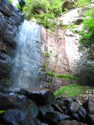
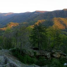
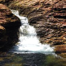
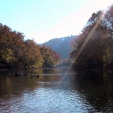
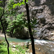
Bad Branch Falls State Nature Preserve is a protected area in Kentucky featuring a waterfall, sandstone cliffs, and forested slopes on the south face of Pine Mountain. A network of hiking trails winds through hemlock forests and mountain terrain, connecting different sections and leading to the main waterfall and deep gorges.

The Nature Conservancy transferred the land to the Kentucky State Nature Preserves Commission in 1985, establishing a long-term partnership for environmental protection. This agreement created the framework for managing and preserving the natural character of the property.

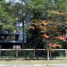
The preserve is home to rare plants and animals that visitors can encounter while walking through the forested areas and along rocky outcrops. This kind of natural setting draws people who want to experience undisturbed forest life and observe wildlife in their natural habitat.

The preserve is accessible via a trail system with footbridges and marked paths that accommodate different fitness levels. Visitors should wear sturdy shoes suitable for mountain terrain and be prepared for wet or slippery conditions near water features.

The water stream drops over a remarkable height in a short distance, creating pools, fast-moving water sections, and wet rock surfaces throughout the preserve. This powerful flow of water shapes the landscape and creates specific habitats found only in such steep environments.

Location: Kentucky

Inception: 1985

GPS coordinates: 37.06750,-82.77210

Latest update: December 11, 2025 18:06

Photos
Around this place
Black Mountain
United States of America

Black Mountain

20.2 km
United States of America

High Knob

23.2 km
Carr Creek Lake
United States of America

Carr Creek Lake

27.7 km
Kentucky Coal Mining Museum
United States of America

Kentucky Coal Mining Museum

19.6 km
Southwest Virginia Museum Historical State Park
United States of America

Southwest Virginia Museum Historical State Park

22.7 km
Carr Creek State Park
United States of America

Carr Creek State Park

27.4 km
Ralph Stanley Museum
United States of America

Ralph Stanley Museum

29.4 km
Wise County Courthouse
United States of America

Wise County Courthouse

19.8 km
June Tolliver House
United States of America

June Tolliver House

22.3 km
John Fox, Jr. House
United States of America

John Fox, Jr. House

22.5 km
E. M. Fulton House
United States of America

E. M. Fulton House

19.6 km
Sunnydale Farm
United States of America

Sunnydale Farm

21.3 km
Terrace Park Girl Scout Cabin
United States of America

Terrace Park Girl Scout Cabin

22.5 km
Devils Fork
United States of America

Devils Fork

28.7 km
Clinch Ranger District Cluster
United States of America

Clinch Ranger District Cluster

16.8 km
Tacoma School
United States of America

Tacoma School

25.9 km
Stonega Historic District
United States of America

Stonega Historic District

12.9 km
Dickenson County Courthouse
United States of America

Dickenson County Courthouse

29.5 km
Derby Historic District
United States of America

Derby Historic District

15.5 km
United States Post Office and Courthouse
United States of America

United States Post Office and Courthouse

22.4 km
Laurel Fork
United States of America

Laurel Fork

31.6 km
North Fork of the Pound
United States of America

North Fork of the Pound

12.3 km
Benham Historic District
United States of America

Benham Historic District

19.6 km
Lynch Historic District
United States of America

Lynch Historic District

17.3 km
Cumberland Central Business District
United States of America

Cumberland Central Business District

22 km
Whitesburg Historic District
United States of America

Whitesburg Historic District

7.3 km
Bolen Building
United States of America

Bolen Building

35.1 km
North Fork Pound Reservoir
United States of America

North Fork Pound Reservoir

14.1 km
Show the full map
Reviews

Visited this place? Tap the stars to rate it and share your experience / photos with the community! Try now! You can cancel it anytime.

« Bad Branch Falls State Nature Preserve - Protected area in Letcher County, Kentucky » is provided by Around Us (aroundus.com). Images and texts are derived from Wikimedia project under a Creative Commons license. You are allowed to copy, distribute, and modify copies of this page, under the conditions set by the license, as long as this note is clearly visible.

Discover hidden gems everywhere you go!

From secret cafés to breathtaking viewpoints, skip the crowded tourist spots and find places that match your style. Our app makes it easy with voice search, smart filtering, route optimization, and insider tips from travelers worldwide. Download now for the complete mobile experience.

Around Us App Screenshot

A unique approach to discovering new places

Le Figaro

All the places worth exploring

France Info

A tailor-made excursion in just a few clicks

20 Minutes