Enable Location

We need your location to show you interesting places around you

Discover nearby places

Find interesting locations and hidden gems around you

Precise directions

Get accurate directions and distances to places

Your location is never shared with other users. It's only used when you tap the location button.

Carr Creek Lake

Log in to your account

Start exploring — it's free

Trusted by 62,483 travelers worldwide

Continue with Google
Continue with Apple
or

We will send you a code to connect

By continuing, you accept our Terms and Conditions and our Privacy Policy

Check your inbox

We've sent a pincode in your inbox. Please enter the code below.

Carr Creek Lake

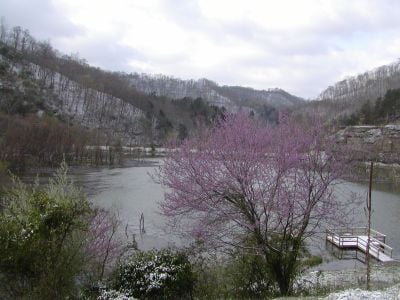
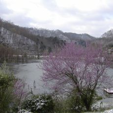
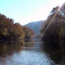
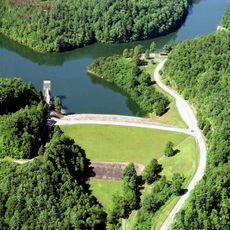
Carr Creek Lake, body of water

Carr Creek Lake is a large reservoir in Knott County created by damming Carr Fork River. The water covers approximately 710 acres and is held by an earthen dam built by the U.S. Army Corps of Engineers, which reveals distinctive layered rock formations at its spillway.

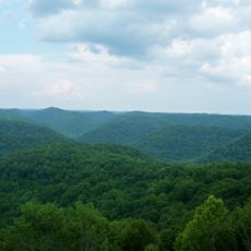
The lake was created in 1976 when the U.S. Army Corps of Engineers built a dam across Carr Fork River to control flooding and provide recreation. The region itself was settled by pioneers starting in the 1770s, with William Carr among the early hunters who gave his name to the creek.

The name "Carr Fork" comes from William Carr, a well-known hunter from the early settlement days in this region. Today, the lake serves as a gathering place where local families and visitors connect with nature through fishing, boating, and quiet reflection by the water.

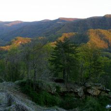
The best time to visit is early morning when the water is calm and wildlife is most active. The park is easily accessible via Kentucky Route 15 and offers a marina with boat rentals, 39 campsites with water and electrical hookups, hiking trails along the shoreline, and picnic areas suitable for day trips or longer stays.

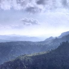
The lake's spillway reveals layered rock formations that tell the geological story of ancient seas and mountain-building events spanning millions of years. These exposed stone layers offer visitors an unexpected window into the deep past of Kentucky's landscape without requiring additional travel.

The community of curious travelers

AroundUs brings together thousands of curated places, local tips, and hidden gems, enriched daily by 60,000 contributors worldwide.

Start exploring
Location
GPS coordinates
37.23500,-83.00300
Latest update
February 9, 2026 08:23
Around this place
Black Mountain
United States of America

Black Mountain

37 km
Bad Branch Falls State Nature Preserve
United States of America

Bad Branch Falls State Nature Preserve

27.7 km
Black Mountain Off-Road Adventure Area
United States of America

Black Mountain Off-Road Adventure Area

42.5 km
Kentucky Coal Mining Museum
United States of America

Kentucky Coal Mining Museum

30.5 km
Southwest Virginia Museum Historical State Park
United States of America

Southwest Virginia Museum Historical State Park

45.9 km
Carr Creek State Park
United States of America

Carr Creek State Park

352 m
Robinson Forest
United States of America

Robinson Forest

29.3 km
June Tolliver House
United States of America

June Tolliver House

45.8 km
John Fox, Jr. House
United States of America

John Fox, Jr. House

45.7 km
E. M. Fulton House
United States of America

E. M. Fulton House

47 km
Sunnydale Farm
United States of America

Sunnydale Farm

40.5 km
John Shell Cabin
United States of America

John Shell Cabin

40.5 km
Wendover, Kentucky
United States of America

Wendover, Kentucky

34.3 km
Terrace Park Girl Scout Cabin
United States of America

Terrace Park Girl Scout Cabin

45.7 km
Buckhorn Presbyterian Church and the Greer Gymnasium
United States of America

Buckhorn Presbyterian Church and the Greer Gymnasium

43.7 km
Clinch Ranger District Cluster
United States of America

Clinch Ranger District Cluster

38 km
Stonega Historic District
United States of America

Stonega Historic District

36.6 km
Derby Historic District
United States of America

Derby Historic District

37.2 km
United States Post Office and Courthouse
United States of America

United States Post Office and Courthouse

45.8 km
Wooton Presbyterian Center
United States of America

Wooton Presbyterian Center

27.2 km
Hindman Historic District
United States of America

Hindman Historic District

11.3 km
North Fork of the Pound
United States of America

North Fork of the Pound

32.7 km
Benham Historic District
United States of America

Benham Historic District

30.6 km
Lynch Historic District
United States of America

Lynch Historic District

31.1 km
Cumberland Central Business District
United States of America

Cumberland Central Business District

28.9 km
Bolen Building
United States of America

Bolen Building

11.2 km
Whitesburg Historic District
United States of America

Whitesburg Historic District

20.5 km
North Fork Pound Reservoir
United States of America

North Fork Pound Reservoir

35.2 km
Show the full map
« Carr Creek Lake - body of water » is provided by Around Us (aroundus.com). Images and texts are derived from Wikimedia project under a Creative Commons license. You are allowed to copy, distribute, and modify copies of this page, under the conditions set by the license, as long as this note is clearly visible.

Discover hidden gems everywhere you go!

From secret cafés to breathtaking viewpoints, skip the crowded tourist spots and find places that match your style. Our app makes it easy with voice search, smart filtering, route optimization, and insider tips from travelers worldwide. Download now for the complete mobile experience.

Around Us App Screenshot

A unique approach to discovering new places

Le Figaro

All the places worth exploring

France Info

A tailor-made excursion in just a few clicks

20 Minutes

Around Us
Travel Guide & Maps
Download

Send to your phone

QR Code
1

Open the camera app on your mobile.

2

Point at the QR code with your camera. A notification will appear.

3

Tap the notification to open the link.