Colchester Village Historic District

Log in to your account

AroundUs is a community-driven map of interesting places, built by curious explorers like you. It grows with every review, story, and photo you share.
Connect to save your favorite spots, contribute locations, and create personalized routes.
Continue with Google
Continue with Apple
Continue with X
Continue with Facebook
Continue with email
By continuing, you accept our Terms and Conditions and our Privacy Policy
Create an account
Add to collection
Map
Suggest a change
Share

Colchester Village Historic District, Historic district at the junction of Routes 16, 85, and Norwich Avenue in Colchester, Connecticut.

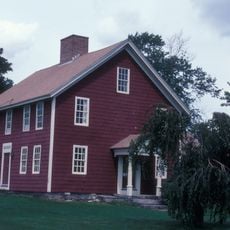
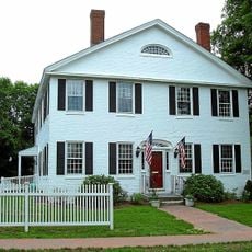
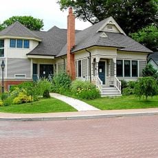
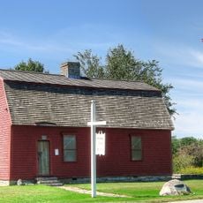
Colchester Village Historic District is a preserved village center in Connecticut with buildings from the colonial period through the 1800s arranged around a town green. The structures include homes, a school building, a church, and former commercial spaces that once served the farming and trading community.

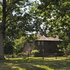
The village began with a meeting house constructed in the late 1600s and expanded as roads connecting major cities were established in the area. Its location at the junction of important routes brought merchants and residents who built the structures visible today.

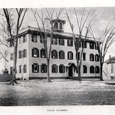
The academy that opened here in the early 1800s brought students and teachers to the village, shaping it as a place focused on learning. This educational role continues to define how locals and visitors understand the village today.

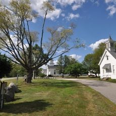
The district is walkable with buildings clustered around the central green and along nearby streets in a compact area. Visitors can park near the green and explore on foot, taking time to view the exteriors and architectural details of each building.

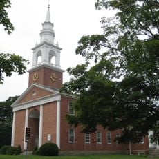
A church with white columns and Greek Revival design stands prominently on the green and serves as a visual anchor for the entire district. The style was common in New England during this period and the building remains one of the most recognizable structures in the village.

Location: Connecticut

GPS coordinates: 41.57444,-72.33167

Latest update: December 14, 2025 17:40

Photos
Around this place
Devil's Hopyard State Park
United States of America

Devil's Hopyard State Park

10.3 km
Lyman Viaduct
United States of America

Lyman Viaduct

10.1 km
Comstock's Bridge
United States of America

Comstock's Bridge

10.1 km
Salmon River State Forest
United States of America

Salmon River State Forest

9.5 km
John Trumbull Birthplace
United States of America

John Trumbull Birthplace

11.9 km
Rapallo Viaduct
United States of America

Rapallo Viaduct

11.7 km
Blackledge River Railroad Bridge
United States of America

Blackledge River Railroad Bridge

7.6 km
Day Pond State Park
United States of America

Day Pond State Park

7.6 km
Old Bacon Academy
United States of America

Old Bacon Academy

169 m
Lebanon Green Historic District
United States of America

Lebanon Green Historic District

11.9 km
Clark Homestead
United States of America

Clark Homestead

11.3 km
Historic Bridges of Devil's Hopyard State Park
United States of America

Historic Bridges of Devil's Hopyard State Park

11 km
Music Vale Seminary
United States of America

Music Vale Seminary

11.1 km
River Road Stone Arch Railroad Bridge
United States of America

River Road Stone Arch Railroad Bridge

7.8 km
Henry Champion House
United States of America

Henry Champion House

7.6 km
Hayward House
United States of America

Hayward House

39 m
Wickham Road Historic District
United States of America

Wickham Road Historic District

8.8 km
Augustus Post House
United States of America

Augustus Post House

9.7 km
Salem Historic District
United States of America

Salem Historic District

10.9 km
Hebron Center Historic District
United States of America

Hebron Center Historic District

9.7 km
Abel H. Fish House
United States of America

Abel H. Fish House

8.5 km
Wheeler Block
United States of America

Wheeler Block

126 m
Zagray Farm Museum
United States of America

Zagray Farm Museum

2.7 km
Bridge No. 1603
United States of America

Bridge No. 1603

11 km
War Office
United States of America

War Office

11.9 km
Bridge No. 1605
United States of America

Bridge No. 1605

11 km
Bridge No. 1604
United States of America

Bridge No. 1604

11 km
Chapman Falls
United States of America

Chapman Falls

10.1 km
Show the full map
Reviews

Visited this place? Tap the stars to rate it and share your experience / photos with the community! Try now! You can cancel it anytime.

« Colchester Village Historic District - Historic district at the junction of Routes 16, 85, and Norwich Avenue in Colchester, Connecticut » is provided by Around Us (aroundus.com). Images and texts are derived from Wikimedia project under a Creative Commons license. You are allowed to copy, distribute, and modify copies of this page, under the conditions set by the license, as long as this note is clearly visible.

Discover hidden gems everywhere you go!

From secret cafés to breathtaking viewpoints, skip the crowded tourist spots and find places that match your style. Our app makes it easy with voice search, smart filtering, route optimization, and insider tips from travelers worldwide. Download now for the complete mobile experience.

Around Us App Screenshot

A unique approach to discovering new places

Le Figaro

All the places worth exploring

France Info

A tailor-made excursion in just a few clicks

20 Minutes