Enable Location

We need your location to show you interesting places around you

Discover nearby places

Find interesting locations and hidden gems around you

Precise directions

Get accurate directions and distances to places

Your location is never shared with other users. It's only used when you tap the location button.

Day Pond State Park

Log in to your account

Start exploring — it's free

Trusted by 63,051 travelers worldwide

Continue with Google
Continue with Apple
or

We will send you a code to connect

By continuing, you accept our Terms and Conditions and our Privacy Policy

Check your inbox

We've sent a pincode in your inbox. Please enter the code below.

Day Pond State Park
Discussion Reviews 1 Photos
1.8k Popularity

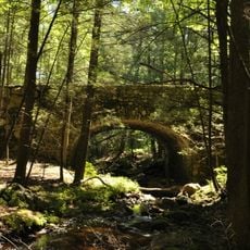
Day Pond State Park, Recreational state park in Colchester, US.

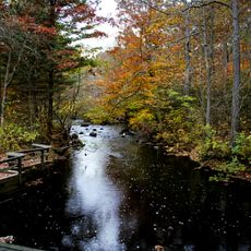
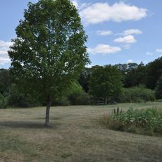
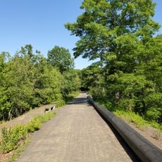
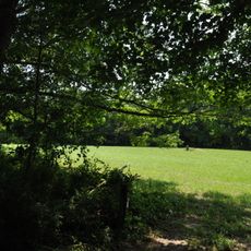
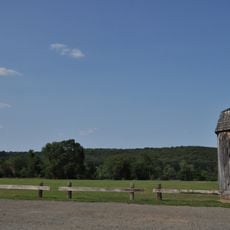
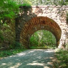
Day Pond State Park is a 180-acre natural area in Connecticut featuring a 7-acre pond ringed by woodland trails and historic stone structures. The property offers miles of paths through different terrain, attracting those seeking outdoor activity and natural surroundings.

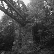
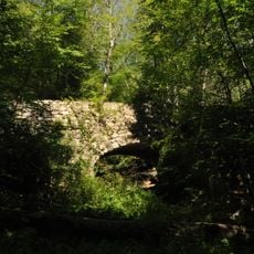
The site was once home to a sawmill operated by the Day family, which used the pond's waterpower to run machinery. The property became a state park in 1949, transforming an industrial site into a public recreation area.

The park serves as a gathering place where locals and visitors come to fish, swim, and enjoy outdoor activities throughout the seasons. The different ways people use the space reflect its importance to the surrounding community.

The park is easy to explore on foot with trails suited to different skill levels, from casual walks to more challenging hikes. Visiting early in the day tends to offer quieter paths and better light for taking in the surroundings.

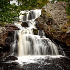
A hidden highlight is Day Pond Brook Falls, a waterfall that drops in several stages down a hillside. This natural feature is easily reached from the main trail and offers an unexpected moment of beauty that many visitors overlook.

The community of curious travelers

AroundUs brings together thousands of curated places, local tips, and hidden gems, enriched daily by 60,000 contributors worldwide.

Start exploring
Location
Inception
1949
Elevation above the sea
140 m
GPS coordinates
41.55333,-72.41833
Latest update
December 14, 2025 12:27
Around this place
Devil's Hopyard State Park
United States of America

Devil's Hopyard State Park

9.9 km
Lyman Viaduct
United States of America

Lyman Viaduct

3 km
Sunrise Resort State Park
United States of America

Sunrise Resort State Park

7.3 km
Comstock's Bridge
United States of America

Comstock's Bridge

2.6 km
Salmon River State Forest
United States of America

Salmon River State Forest

2 km
Machimoodus State Park
United States of America

Machimoodus State Park

8.3 km
Marlborough Tavern
United States of America

Marlborough Tavern

9.3 km
Rapallo Viaduct
United States of America

Rapallo Viaduct

4.9 km
Blackledge River Railroad Bridge
United States of America

Blackledge River Railroad Bridge

3.2 km
Brainard Homestead State Park
United States of America

Brainard Homestead State Park

10.3 km
Old Bacon Academy
United States of America

Old Bacon Academy

7.4 km
Amasa Day House
United States of America

Amasa Day House

6.4 km
Haddam Meadows State Park
United States of America

Haddam Meadows State Park

11 km
Colchester Village Historic District
United States of America

Colchester Village Historic District

7.6 km
Historic Bridges of Devil's Hopyard State Park
United States of America

Historic Bridges of Devil's Hopyard State Park

10.7 km
River Road Stone Arch Railroad Bridge
United States of America

River Road Stone Arch Railroad Bridge

3.1 km
Henry Champion House
United States of America

Henry Champion House

1.1 km
Hayward House
United States of America

Hayward House

7.6 km
Wickham Road Historic District
United States of America

Wickham Road Historic District

6.3 km
Belltown Historic District
United States of America

Belltown Historic District

7.5 km
Middle Haddam School
United States of America

Middle Haddam School

10.8 km
Wheeler Block
United States of America

Wheeler Block

7.6 km
Marlborough Congregational Church
United States of America

Marlborough Congregational Church

9 km
Zagray Farm Museum
United States of America

Zagray Farm Museum

8.1 km
Bridge No. 1603
United States of America

Bridge No. 1603

10.7 km
Bridge No. 1605
United States of America

Bridge No. 1605

10.7 km
Bridge No. 1604
United States of America

Bridge No. 1604

10.7 km
Chapman Falls
United States of America

Chapman Falls

10 km
Show the full map
Reviews
Share your experience

No review yet

Discussions
Start a discussion...

No discussion yet

« Day Pond State Park - Recreational state park in Colchester, US » is provided by Around Us (aroundus.com). Images and texts are derived from Wikimedia project under a Creative Commons license. You are allowed to copy, distribute, and modify copies of this page, under the conditions set by the license, as long as this note is clearly visible.

Discover hidden gems everywhere you go!

From secret cafés to breathtaking viewpoints, skip the crowded tourist spots and find places that match your style. Our app makes it easy with voice search, smart filtering, route optimization, and insider tips from travelers worldwide. Download now for the complete mobile experience.

Around Us App Screenshot

A unique approach to discovering new places

Le Figaro

All the places worth exploring

France Info

A tailor-made excursion in just a few clicks

20 Minutes

Around Us
Travel Guide & Maps
Download

Send to your phone

QR Code
1

Open the camera app on your mobile.

2

Point at the QR code with your camera. A notification will appear.

3

Tap the notification to open the link.