Enable Location

We need your location to show you interesting places around you

Discover nearby places

Find interesting locations and hidden gems around you

Precise directions

Get accurate directions and distances to places

Your location is never shared with other users. It's only used when you tap the location button.

Cope's Bridge

Log in to your account

Start exploring — it's free

Trusted by 62,796 travelers worldwide

Continue with Google
Continue with Apple
or

We will send you a code to connect

By continuing, you accept our Terms and Conditions and our Privacy Policy

Check your inbox

We've sent a pincode in your inbox. Please enter the code below.

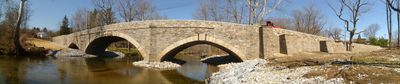
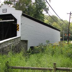
Cope's Bridge, Stone arch bridge in East Bradford, United States.

Cope's Bridge is a stone arch structure that carries Strasburg Road across the East Branch Brandywine Creek in East Bradford, Pennsylvania. The design features sturdy arched stonework that has supported both water flow and vehicle traffic for nearly 200 years.

The bridge was built in 1807 as part of early transportation development in Pennsylvania. It has survived changing traffic patterns and engineering standards while maintaining its original stone construction.

The bridge serves as a daily crossing for local residents and remains woven into the fabric of community life. It reflects the skill of craftspeople who built it using methods passed down through generations.

The bridge is accessible by car along Strasburg Road and can be reached throughout the day. The area is rural, so plan accordingly if you want to visit and spend time exploring the surroundings.

The arching design works the same way as ancient Roman bridges, even though 19th-century builders had no access to Roman knowledge. Both eras discovered that stone arches distribute weight more efficiently than flat spans.

The community of curious travelers

AroundUs brings together thousands of curated places, local tips, and hidden gems, enriched daily by 60,000 contributors worldwide.

Start exploring
Location
Inception
1807
GPS coordinates
39.95890,-75.65540
Latest update
December 14, 2025 17:01
Around this place
Chester County Courthouse
United States of America

Chester County Courthouse

4.3 km
Warner Theatre
United States of America

Warner Theatre

4.2 km
Bank of Chester County
United States of America

Bank of Chester County

4.3 km
Farmers and Mechanics Building
United States of America

Farmers and Mechanics Building

4.3 km
West Chester Downtown Historic District
United States of America

West Chester Downtown Historic District

4.3 km
Barclay House
United States of America

Barclay House

4 km
Trimbleville Historic District
United States of America

Trimbleville Historic District

3.8 km
Humphry Marshall House
United States of America

Humphry Marshall House

2.4 km
Gibson's Covered Bridge
United States of America

Gibson's Covered Bridge

3.1 km
West Chester Boarding School for Boys
United States of America

West Chester Boarding School for Boys

4.3 km
Col. John Hannum House
United States of America

Col. John Hannum House

1.1 km
Sharples Homestead
United States of America

Sharples Homestead

4.4 km
William Everhart Buildings
United States of America

William Everhart Buildings

4.2 km
Temple-Webster-Stoner House
United States of America

Temple-Webster-Stoner House

4.2 km
Strode's Mill
United States of America

Strode's Mill

4.7 km
Hance House and Barn
United States of America

Hance House and Barn

3.5 km
Wilkinson House
United States of America

Wilkinson House

3.8 km
Derbydown Homestead
United States of America

Derbydown Homestead

4.6 km
East Bradford Boarding School for Boys
United States of America

East Bradford Boarding School for Boys

4.5 km
Baily Farm
United States of America

Baily Farm

4.2 km
Strode's Mill Historic District
United States of America

Strode's Mill Historic District

4.7 km
Taylor House
United States of America

Taylor House

511 m
George Hoffman House
United States of America

George Hoffman House

4.5 km
Newlin Miller's House
United States of America

Newlin Miller's House

4.3 km
Paradise Valley Historic District
United States of America

Paradise Valley Historic District

3 km
Taylor-Cope Historic District
United States of America

Taylor-Cope Historic District

700 m
Worth-Jefferis Rural Historic District
United States of America

Worth-Jefferis Rural Historic District

2.4 km
Carter-Worth House and Farm
United States of America

Carter-Worth House and Farm

1.8 km
Show the full map
« Cope's Bridge - Stone arch bridge in East Bradford, United States » is provided by Around Us (aroundus.com). Images and texts are derived from Wikimedia project under a Creative Commons license. You are allowed to copy, distribute, and modify copies of this page, under the conditions set by the license, as long as this note is clearly visible.

Discover hidden gems everywhere you go!

From secret cafés to breathtaking viewpoints, skip the crowded tourist spots and find places that match your style. Our app makes it easy with voice search, smart filtering, route optimization, and insider tips from travelers worldwide. Download now for the complete mobile experience.

Around Us App Screenshot

A unique approach to discovering new places

Le Figaro

All the places worth exploring

France Info

A tailor-made excursion in just a few clicks

20 Minutes

Around Us
Travel Guide & Maps
Download

Send to your phone

QR Code
1

Open the camera app on your mobile.

2

Point at the QR code with your camera. A notification will appear.

3

Tap the notification to open the link.